FAA INFORMATION EFFECTIVE 11 JUNE 2026
Location
| FAA Identifier: | 08K |
| Lat/Long: | 40-39-04.8000N 098-04-47.6000W
40-39.080000N 098-04.793333W
40.6513333,-98.0798889
(estimated) |
| Elevation: | 1814.5 ft. / 553.1 m (surveyed) |
| Variation: | 05E (2010) |
| From city: | 2 miles NE of HARVARD, NE |
| Time zone: | UTC -5 (UTC -6 during Standard Time) |
| Zip code: | 68944 |
Airport Operations
| Airport use: | Open to the public |
| Activation date: | 04/1944 |
| Control tower: | no |
| ARTCC: | MINNEAPOLIS CENTER |
| FSS: | COLUMBUS FLIGHT SERVICE STATION |
| NOTAMs facility: | OLU (NOTAM-D service available) |
| Attendance: | UNATNDD
AMGR LCTD OFFSITE; CALL FOR ASSISTANCE 402-266-1890. |
| Wind indicator: | lighted |
| Segmented circle: | yes |
| Lights: | ACTVT MIRL RWY 17-35 - CTAF. |
| Beacon: | white-green (lighted land airport)
Operates sunset to sunrise. |
Airport Communications
| CTAF: | 122.9 |
| WX AWOS-3 at AUH (15 nm N): | 121.225 (402-694-5472) |
| WX ASOS at HSI (16 nm W): | 120.525 (402-463-4029) |
- APCH/DEP SVC PRVDD BY MINNEAPOLIS ARTCC ON FREQS 119.4/278.8 (HASTINGS RCAG).
Nearby radio navigation aids
| VOR radial/distance | | VOR name | | Freq | | Var |
|---|
| GRIr145/22.6 | | GRAND ISLAND VOR/DME | | 116.55 | | 07E |
| NDB name | | Hdg/Dist | | Freq | | Var | | ID |
|---|
| BEKLOF | | 276/23.6 | | 392 | | 03E | | FMZ | ..-. -- --.. |
| YORK | | 229/25.7 | | 257 | | 06E | | JYR | .--- -.-- .-. |
Airport Services
| Fuel available: | 100LL
100LL:CTC AMGR FOR FUEL; CASH OR CK ONLY 402-266-1890. |
| Parking: | tiedowns |
| Airframe service: | NONE |
| Powerplant service: | NONE |
| Bottled oxygen: | NONE |
| Bulk oxygen: | NONE |
Runway Information
Runway 17/35
| Dimensions: | 3722 x 60 ft. / 1134 x 18 m |
| Surface: | asphalt, in good condition |
| Runway edge lights: | medium intensity |
| RUNWAY 17 | | RUNWAY 35 |
| Latitude: | 40-39.341650N | | 40-38.728752N |
| Longitude: | 098-04.952232W | | 098-04.945277W |
| Elevation: | 1814.1 ft. | | 1806.2 ft. |
| Traffic pattern: | left | | left |
| Runway heading: | 175 magnetic, 180 true | | 355 magnetic, 360 true |
| Markings: | nonprecision, in good condition | | nonprecision, in good condition |
| Touchdown point: | yes, no lights | | yes, no lights |
Runway 14/32
| Dimensions: | 3873 x 150 ft. / 1180 x 46 m |
| Surface: | turf, in fair condition |
| RUNWAY 14 | | RUNWAY 32 |
| Latitude: | 40-39.388315N | | 40-38.857648N |
| Longitude: | 098-04.876508W | | 098-04.412173W |
| Elevation: | 1810.1 ft. | | 1808.4 ft. |
| Traffic pattern: | left | | left |
| Runway heading: | 142 magnetic, 147 true | | 322 magnetic, 327 true |
| Touchdown point: | yes, no lights | | yes, no lights |
Airport Ownership and Management from official FAA records
| Ownership: | Publicly-owned |
| Owner: | NEBR. DOT, DIVISION OF AERONAUTICS
1600 NEBRASKA PARKWAY
LINCOLN, NE 68502-4101
Phone 402-471-2371 |
| Manager: | TIM KRIENERT
13 AIRBASE ROAD, FAIRMONT STATE AIRFIELD
FAIRMONT, NE 68354-4057
Phone 402-266-1890 |
Additional Remarks
| - | FOR CD CTC MINNEAPOLIS ARTCC AT 651-463-5588. |
Instrument Procedures
NOTE: All procedures below are presented as PDF files. If you need a reader for these files, you should download the free Adobe Reader.NOT FOR NAVIGATION. Please procure official charts for flight.
FAA instrument procedures published for use from 11 June 2026 at 0901Z to 09 July 2026 at 0900z.
IAPs - Instrument Approach Procedures |
|---|
| RNAV (GPS) RWY 17 | |
download (187KB) |
| RNAV (GPS) RWY 35 | |
download (181KB) |
| NOTE: Special Take-Off Minimums/Departure Procedures apply | |
download (360KB) |
Other nearby airports with instrument procedures:
KAUH - Aurora Municipal Airport/Al Potter Field (15 nm N)
KHSI - Hastings Municipal Airport (16 nm W)
KGRI - Central Nebraska Regional Airport (22 nm NW)
KFMZ - Fairmont State Airport (23 nm E)
KJYR - York Municipal Airport (25 nm NE)
|
|

Road maps at:
MapQuest
Bing
Google
| Aerial photo |
|---|

|
| Sectional chart |
|---|
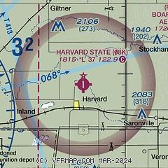
|
| Airport distance calculator |
|---|
|
|
| Sunrise and sunset |
|---|
|
Times for 14-Jun-2026
| | Local
(UTC-5) | | Zulu
(UTC) |
|---|
| Morning civil twilight | | 05:28 | | 10:28 |
| Sunrise | | 06:02 | | 11:02 |
| Sunset | | 21:03 | | 02:03 |
| Evening civil twilight | | 21:37 | | 02:37 |
|
| Current date and time |
|---|
| Zulu (UTC) | 14-Jun-2026 08:45:15 |
|---|
| Local (UTC-5) | 14-Jun-2026 03:45:15 |
|---|
|
| METAR |
|---|
KAUH
14nm N | 140835Z AUTO 34009KT 10SM CLR 12/08 A3015 RMK AO2 T01200084
|
KHSI
16nm W | 140753Z AUTO 33006KT 10SM CLR 12/08 A3017 RMK AO2 SLP209 T01170078
|
KGRI
22nm NW | 140753Z AUTO 29004KT 10SM CLR 12/07 A3018 RMK AO2 SLP217 T01170067
|
KJYR
26nm NE | 140835Z AUTO 31008KT 10SM CLR 12/10 A3014 RMK AO2
|
|
| TAF |
|---|
KGRI
22nm NW | 140525Z 1406/1506 33009KT P6SM FEW100 FM141500 34012G18KT P6SM SCT070 FM142100 33009KT P6SM BKN090 FM150100 29005KT P6SM BKN090
|
|
| NOTAMs |
|---|
NOTAMs are issued by the DoD/FAA and will open in a separate window not controlled by AirNav.
|
|

