FAA INFORMATION EFFECTIVE 22 JANUARY 2026
Location
| FAA Identifier: | 0V3 |
| Lat/Long: | 40-30-53.7000N 098-56-44.3000W
40-30.895000N 098-56.738333W
40.5149167,-98.9456389
(estimated) |
| Elevation: | 2160.4 ft. / 658.5 m (surveyed) |
| Variation: | 07E (2000) |
| From city: | 1 mile NE of MINDEN, NE |
| Time zone: | UTC -6 (UTC -5 during Daylight Saving Time) |
| Zip code: | 68959 |
Airport Operations
| Airport use: | Open to the public |
| Activation date: | 02/1950 |
| Control tower: | no |
| ARTCC: | MINNEAPOLIS CENTER |
| FSS: | COLUMBUS FLIGHT SERVICE STATION |
| NOTAMs facility: | OLU (NOTAM-D service available) |
| Attendance: | UNATNDD |
| Wind indicator: | lighted |
| Segmented circle: | yes |
| Lights: | ACTVT PAPI RWYS 16 & 34; MIRL RWY 16/34 - CTAF. |
| Beacon: | white-green (lighted land airport)
Operates sunset to sunrise. |
Airport Communications
| CTAF/UNICOM: | 122.7 |
| WX AWOS-3PT at EAR (13 nm N): | 123.875 (308-237-5608) |
| WX AWOS-3 at HDE (18 nm W): | 121.325 (308-995-6433) |
- APCH/DEP SVC PRVDD BY MINNEAPOLIS ARTCC ON FREQUENCIES 119.4/278.8 (HASTINGS RCAG).
Nearby radio navigation aids
| VOR radial/distance | | VOR name | | Freq | | Var |
|---|
| EARr163/(12.9) | | KEARNEY VOR | | 111.20 | | 05E |
Airport Services
| Fuel available: | 100LL |
| Parking: | tiedowns |
| Bottled oxygen: | NONE |
| Bulk oxygen: | NONE |
Runway Information
Runway 16/34
| Dimensions: | 3900 x 60 ft. / 1189 x 18 m |
| Surface: | concrete, in good condition |
| Weight bearing capacity: | | Single wheel: | 30.0 | | Double wheel: | 52.0 |
|
| Runway edge lights: | medium intensity |
| RUNWAY 16 | | RUNWAY 34 |
| Latitude: | 40-31.179032N | | 40-30.554652N |
| Longitude: | 098-56.848502W | | 098-56.651103W |
| Elevation: | 2156.3 ft. | | 2152.7 ft. |
| Traffic pattern: | left | | right |
| Runway heading: | 159 magnetic, 166 true | | 339 magnetic, 346 true |
| Markings: | nonprecision, in good condition | | nonprecision, in good condition |
| Visual slope indicator: | 2-light PAPI on left (3.00 degrees glide path) | | 2-light PAPI on left (3.50 degrees glide path) |
| Touchdown point: | yes, no lights | | yes, no lights |
| Obstructions: | 5 ft. fence, 340 ft. from runway, 28:1 slope to clear
UNLIGHTED PIVOT IRRIGATION SYSTEM ROTATES THROUGH APPROACH AREA DURING IRRIGATION SEASON. | | 44 ft. trees, 985 ft. from runway, 256 ft. right of centerline, 17:1 slope to clear |
Runway 5/23
| Dimensions: | 1275 x 300 ft. / 389 x 91 m |
| Surface: | turf, in good condition |
| RUNWAY 5 | | RUNWAY 23 |
| Latitude: | 40-30.926083N | | 40-31.034167N |
| Longitude: | 098-56.824100W | | 098-56.588217W |
| Elevation: | 2154.0 ft. | | 2155.0 ft. |
| Traffic pattern: | left | | left |
| Runway heading: | 052 magnetic, 059 true | | 232 magnetic, 239 true |
| Touchdown point: | yes, no lights | | yes, no lights |
Airport Ownership and Management from official FAA records
| Ownership: | Publicly-owned |
| Owner: | MINDEN AIRPORT AUTHORITY
PO BOX 295
MINDEN, NE 68959-0295
Phone 308-830-0391 |
| Manager: | BRENT STEWART
PO BOX 295
MINDEN, NE 68959-0295
Phone 308-830-0391
FOR SVC CTC BRENT 308-830-0391. |
Additional Remarks
| A52-23 | GAS LINE MARKER POLE. |
| A57-05 | RWY 23 UNLGTD PIVOT IRRIGATION SYS ROTS THROUGH APCH AREA DURING IRRIGATION SEASON. PIVOT IS 16 FT ABV; 205 FT OUT, 0B; 12:1 WHEN IN APCH. |
| - | TWR 1163 FT AGL 3240 FT MSL 9 NM ENE. |
| - | ULTRALIGHT ACTVY ON AND INVOF ARPT. |
| - | FOR CD CTC MINNEAPOLIS ARTCC AT 651-463-5588. |
Instrument Procedures
NOTE: All procedures below are presented as PDF files. If you need a reader for these files, you should download the free Adobe Reader.NOT FOR NAVIGATION. Please procure official charts for flight.
FAA instrument procedures published for use from 22 January 2026 at 0901Z to 19 February 2026 at 0900z.
IAPs - Instrument Approach Procedures |
|---|
| RNAV (GPS) RWY 16 | |
download (197KB) |
| RNAV (GPS) RWY 34 | |
download (182KB) |
| NOTE: Special Take-Off Minimums/Departure Procedures apply | |
download (352KB) |
Other nearby airports with instrument procedures:
KEAR - Kearney Regional Airport (13 nm N)
KHDE - Brewster Field Airport (18 nm W)
KHSI - Hastings Municipal Airport (24 nm E)
4D9 - Alma Municipal Airport (30 nm SW)
7V7 - Red Cloud Municipal Airport (32 nm SE)
|
|

Road maps at:
MapQuest
Bing
Google
| Aerial photo |
|---|
WARNING: Photo may not be current or correct
 Photo by Chuck Jacobsen
Photo taken 15-Jun-2011
looking south.
Photo by Chuck Jacobsen
Photo taken 15-Jun-2011
looking south.
Do you have a better or more recent aerial photo of Pioneer Village Field Airport that you would like to share? If so, please send us your photo.
|
| Sectional chart |
|---|
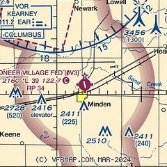
|
| Airport distance calculator |
|---|
|
|
| Sunrise and sunset |
|---|
|
Times for 31-Jan-2026
| | Local
(UTC-6) | | Zulu
(UTC) |
|---|
| Morning civil twilight | | 07:18 | | 13:18 |
| Sunrise | | 07:47 | | 13:47 |
| Sunset | | 17:51 | | 23:51 |
| Evening civil twilight | | 18:20 | | 00:20 |
|
| Current date and time |
|---|
| Zulu (UTC) | 31-Jan-2026 20:04:32 |
|---|
| Local (UTC-6) | 31-Jan-2026 14:04:32 |
|---|
|
| METAR |
|---|
KEAR
12nm N | 311956Z AUTO 17014KT 10SM OVC041 M08/M12 A3033 RMK AO2 SLP318 T10831122 FZRANO
|
KHDE
17nm W | 311955Z AUTO 18014KT 10SM OVC050 M08/M12 A3030 RMK AO2 T10791121
|
KHSI
24nm E | 311953Z AUTO 18009G18KT 10SM OVC065 M09/M17 A3037 RMK AO2 SLP331 T10941167 $
|
|
| TAF |
|---|
KEAR
12nm N | 311720Z 3118/0118 19014G24KT P6SM SCT028 OVC060 PROB30 3118/3121 4SM -SN BKN028 FM312100 18015G26KT 4SM -SN SCT020 OVC030 FM312300 18012KT P6SM SCT020 OVC040 PROB30 3123/0102 5SM -SN BKN025 FM010700 23009KT P6SM SCT220 WS020/32040KT FM011600 29009KT P6SM SCT250
|
|
| NOTAMs |
|---|
NOTAMs are issued by the DoD/FAA and will open in a separate window not controlled by AirNav.
|
|

