FAA INFORMATION EFFECTIVE 14 MAY 2026
Location
| FAA Identifier: | 3DW |
| Lat/Long: | 37-13-21.7400N 093-14-54.0550W
37-13.362333N 093-14.900917W
37.2227056,-93.2483486
(estimated) |
| Elevation: | 1375 ft. / 419 m (estimated) |
| Variation: | 01E (2020) |
| Time zone: | UTC -5 (UTC -6 during Standard Time) |
| Zip code: | 65802 |
Airport Operations
| Airport use: | Open to the public |
| Activation date: | 04/1948 |
| Control tower: | no |
| ARTCC: | KANSAS CITY CENTER |
| FSS: | COLUMBIA FLIGHT SERVICE STATION |
| NOTAMs facility: | COU (NOTAM-D service available) |
| Attendance: | MON-FRI 0730-1800, ALL SAT 0900-1600 |
| Wind indicator: | lighted |
| Segmented circle: | no |
| Lights: | ACTVT NSTD MIRL RWY 11/29 - CTAF-THREE CLICKS. |
Airport Communications
| CTAF/UNICOM: | 122.8 |
| SPRINGFIELD APPROACH: | 124.95 |
| SPRINGFIELD DEPARTURE: | 124.95 |
| WX ASOS at SGF (7 nm W): | PHONE 417-869-4491 |
Nearby radio navigation aids
| VOR radial/distance | | VOR name | | Freq | | Var |
|---|
| SGFr149/9.0 | | SPRINGFIELD VORTAC | | 116.90 | | 04E |
| DGDr303/21.4 | | DOGWOOD VORTAC | | 109.40 | | 01E |
Airport Services
| Fuel available: | 100LL JET-A |
| Parking: | hangars and tiedowns |
| Airframe service: | MAJOR |
| Powerplant service: | MAJOR |
| Bottled oxygen: | HIGH/LOW |
| Bulk oxygen: | NONE |
Runway Information
Runway 11/29
| Dimensions: | 4037 x 50 ft. / 1230 x 15 m |
| Surface: | asphalt, in good condition |
| Weight bearing capacity: | |
| Runway edge lights: | non-standard
NSTD MIRL; 3 THR LGTS EACH RWY, EDGE LGTS SPACED 240 FT APART. |
| RUNWAY 11 | | RUNWAY 29 |
| Latitude: | 37-13.470833N | | 37-13.253833N |
| Longitude: | 093-15.294167W | | 093-14.507667W |
| Elevation: | 1355.0 ft. | | 1375.0 ft. |
| Traffic pattern: | left | | left |
| Runway heading: | 108 magnetic, 109 true | | 288 magnetic, 289 true |
| Markings: | nonprecision, in fair condition | | nonprecision, in fair condition |
| Touchdown point: | yes, no lights | | yes, no lights |
| Obstructions: | 44 ft. trees, 890 ft. from runway, 116 ft. left of centerline, 15:1 slope to clear | | 58 ft. trees, 1080 ft. from runway, 130 ft. left of centerline, 15:1 slope to clear |
Airport Ownership and Management from official FAA records
| Ownership: | Privately-owned |
| Owner: | SHERMAN STREET ACQUISITION CO INC
605 N. SHERMAN ST
SPRINGFIELD, MO 65803 |
| Manager: | LAUREN LEA
2546 E DIVISION ST
SPRINGFIELD, MO 65803
Phone 417-862-2418 |
Additional Remarks
| - | 600 FT LGTD TOWER 950 FT N OF RY 29 THLD. |
| - | NTSD RY SAFETY AREA BYD RY 29 THLD; LARGE SLOPE. |
| - | PEDESTRIAN GATE CODE IS CTAF FREQ. |
| - | FOR CD CTC SPRINGFIELD APCH AT 417-868-5620/5619. |
Instrument Procedures
NOTE: All procedures below are presented as PDF files. If you need a reader for these files, you should download the free Adobe Reader.NOT FOR NAVIGATION. Please procure official charts for flight.
FAA instrument procedures published for use from 14 May 2026 at 0901Z to 11 June 2026 at 0900Z.
IAPs - Instrument Approach Procedures |
|---|
| RNAV (GPS)-A | |
download (183KB) |
| RNAV (GPS)-B | |
download (179KB) |
| NOTE: Special Take-Off Minimums/Departure Procedures apply | |
download (236KB) |
Other nearby airports with instrument procedures:
KSGF - Springfield-Branson National Airport (7 nm W)
M17 - Bolivar Municipal Airport (23 nm N)
2H2 - Jerry Sumners Sr. Aurora Municipal Airport (26 nm SW)
KAOV - Ava Bill Martin Memorial Airport (31 nm SE)
KFWB - Branson West Municipal Airport/Emerson Field (32 nm S)
|
|

Road maps at:
MapQuest
Bing
Google
| Aerial photo |
|---|
WARNING: Photo may not be current or correct
 Photo taken 18-Oct-2014
looking northwest.
Photo taken 18-Oct-2014
looking northwest.
Do you have a better or more recent aerial photo of Downtown Airport that you would like to share? If so, please send us your photo.
|
| Sectional chart |
|---|
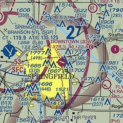
|
| Airport distance calculator |
|---|
|
|
| Sunrise and sunset |
|---|
|
Times for 08-Jun-2026
| | Local
(UTC-5) | | Zulu
(UTC) |
|---|
| Morning civil twilight | | 05:23 | | 10:23 |
| Sunrise | | 05:53 | | 10:53 |
| Sunset | | 20:31 | | 01:31 |
| Evening civil twilight | | 21:01 | | 02:01 |
|
| Current date and time |
|---|
| Zulu (UTC) | 08-Jun-2026 06:57:26 |
|---|
| Local (UTC-5) | 08-Jun-2026 01:57:26 |
|---|
|
| METAR |
|---|
KSGF
6nm W | 080652Z 15011KT 10SM FEW035 22/21 A2982 RMK AO2 LTG DSNT N AND SE AND NW SLP084 T02170211 $
|
|
| TAF |
|---|
KSGF
6nm W | 080528Z 0806/0906 18010KT P6SM BKN040 TEMPO 0806/0809 1SM TSRA OVC025CB FM080900 18009KT 2SM TSRA OVC035CB TEMPO 0809/0813 1SM TSRA OVC020CB FM081300 19011KT 6SM -SHRA OVC040 PROB30 0813/0818 2SM TSRA OVC025CB FM081800 20012KT P6SM BKN250 FM090100 18009KT P6SM SCT030
|
|
| NOTAMs |
|---|
NOTAMs are issued by the DoD/FAA and will open in a separate window not controlled by AirNav.
|
|


