FAA INFORMATION EFFECTIVE 14 MAY 2026
Location
| FAA Identifier: | 43Y |
| Lat/Long: | 47-53-16.7776N 094-15-29.2650W
47-53.279627N 094-15.487750W
47.8879938,-94.2581292
(estimated) |
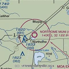
| Elevation: | 1430 ft. / 436 m (estimated) |
| Variation: | 04E (1985) |
| From city: | 2 miles NE of NORTHOME, MN |
| Time zone: | UTC -5 (UTC -6 during Standard Time) |
| Zip code: | 56661 |
Airport Operations
| Airport use: | Open to the public |
| Activation date: | 05/1947 |
| Control tower: | no |
| ARTCC: | MINNEAPOLIS CENTER |
| FSS: | PRINCETON FLIGHT SERVICE STATION |
| NOTAMs facility: | PNM (NOTAM-D service available) |
| Attendance: | UNATNDD |
| Wind indicator: | lighted |
| Segmented circle: | no |
| Lights: | SS-SR |
| Beacon: | white-green (lighted land airport)
Operates sunset to sunrise. |
Airport Communications
| CTAF: | 122.9 |
| WX AWOS-3PT at VWU (19 nm NW): | 124.175 (218-647-8415) |
Nearby radio navigation aids
| VOR radial/distance | | VOR name | | Freq | | Var |
|---|
| IDJr049/35.2 | | LAKE BEMIDJI VOR/DME | | 110.00 | | 01E |
Airport Services
Runway Information
Runway 12/30
| Dimensions: | 3199 x 147 ft. / 975 x 45 m |
| Surface: | turf, in good condition
RUTS IN RWY. |
| Runway edge lights: | non-standard
NSTD LIRL DUE TO VRB SPACING, NMRS RWY EDGE LGTS INOP. |
| Runway edge markings: | YELLOW CONES. |
| RUNWAY 12 | | RUNWAY 30 |
| Latitude: | 47-53.416833N | | 47-53.092833N |
| Longitude: | 094-15.701000W | | 094-15.085333W |
| Elevation: | 1423.0 ft. | | 1430.0 ft. |
| Traffic pattern: | left | | left |
| Runway heading: | 124 magnetic, 128 true | | 304 magnetic, 308 true |
| Obstructions: | 68 ft. tree, 1283 ft. from runway, 292 ft. left of centerline, 18:1 slope to clear | | 74 ft. trees, 1299 ft. from runway, 154 ft. right of centerline, 17:1 slope to clear |
Runway 2/20
| Dimensions: | 2049 x 148 ft. / 625 x 45 m |
| Surface: | turf, in fair condition |
| Runway edge markings: | RWY & DTHR MKD WITH YELLOW CONES. |
| Operational restrictions: | NOT MNTND WINTER MONTHS. |
| RUNWAY 2 | | RUNWAY 20 |
| Latitude: | 47-53.162000N | | 47-53.474667N |
| Longitude: | 094-15.728500W | | 094-15.542333W |
| Elevation: | 1420.0 ft. | | 1421.0 ft. |
| Traffic pattern: | left | | left |
| Runway heading: | 018 magnetic, 022 true | | 198 magnetic, 202 true |
| Displaced threshold: | no | | 209 ft. |
| Touchdown point: | yes, no lights | | yes, no lights |
| Obstructions: | 29 ft. trees, 394 ft. from runway, 201 ft. right of centerline, 13:1 slope to clear | | 54 ft. trees, 745 ft. from runway, 146 ft. left of centerline, 13:1 slope to clear |
Airport Ownership and Management from official FAA records
| Ownership: | Publicly-owned |
| Owner: | CITY OF NORTHOME
PO BOX 65, 12068 MAIN ST
NORTHOME, MN 56661-0065
Phone 218-897-5762 |
| Manager: | PETER BENDER
PO BOX 65, 12068 MAIN ST
NORTHOME, MN 56661-0065
Phone 218-434-1743
NORTHOME@PAULBUNYAN.NET. |
Additional Remarks
| A30A-02 | UNEVEN SFC NEAR RWY END. |
| - | FOR CD CTC MINNEAPOLIS ARTCC AT 651-463-5588. |
Instrument Procedures
There are no published instrument procedures at 43Y.
Some nearby airports with instrument procedures:
KFOZ - Bigfork Municipal Airport (25 nm E)
KBJI - Bemidji Regional Airport (35 nm SW)
Y49 - Walker Municipal Airport (46 nm S)
KGPZ - Grand Rapids/Itasca County Airport-Gordon Newstrom Field (51 nm SE)
KBDE - Baudette International Airport (52 nm N)
|
|

Road maps at:
MapQuest
Bing
Google
| Aerial photo |
|---|
WARNING: Photo may not be current or correct
 Photo taken 26-Jun-2008
Do you have a better or more recent aerial photo of Northome Municipal Airport that you would like to share? If so, please send us your photo.
|
| Sectional chart |
|---|
|
| Airport distance calculator |
|---|
|
|
| Sunrise and sunset |
|---|
|
Times for 20-May-2026
| | Local
(UTC-5) | | Zulu
(UTC) |
|---|
| Morning civil twilight | | 04:56 | | 09:56 |
| Sunrise | | 05:34 | | 10:34 |
| Sunset | | 20:53 | | 01:53 |
| Evening civil twilight | | 21:31 | | 02:31 |
|
| Current date and time |
|---|
| Zulu (UTC) | 20-May-2026 11:41:15 |
|---|
| Local (UTC-5) | 20-May-2026 06:41:15 |
|---|
|
| METAR |
|---|
KVWU
19nm NW | 201120Z AUTO 31006KT 10SM CLR 06/06 A3027 RMK AO2
|
KFOZ
26nm E | 201115Z AUTO 00000KT 9SM CLR M01/M01 A3025 RMK AO2 T10091009
|
KBJI
35nm SW | 201115Z AUTO 00000KT 7SM CLR M01/M01 A3029 RMK AO2 T10101010
|
|
| TAF |
|---|
KBJI
35nm SW | 200520Z 2006/2106 VRB02KT P6SM SKC FM202000 18004KT P6SM SKC
|
|
| NOTAMs |
|---|
NOTAMs are issued by the DoD/FAA and will open in a separate window not controlled by AirNav.
|
|

