FAA INFORMATION EFFECTIVE 19 MARCH 2026
Location
| FAA Identifier: | 6J6 |
| Lat/Long: | 33-44-12.7000N 081-49-07.5000W
33-44.211667N 081-49.125000W
33.7368611,-81.8187500
(estimated) |
| Elevation: | 611 ft. / 186 m (estimated) |
| Variation: | 04W (1985) |
| From city: | 1 mile SE of TRENTON, SC |
| Time zone: | UTC -4 (UTC -5 during Standard Time) |
| Zip code: | 29847 |
Airport Operations
| Airport use: | Open to the public |
| Activation date: | 12/1954 |
| Control tower: | no |
| ARTCC: | ATLANTA CENTER |
| FSS: | ANDERSON FLIGHT SERVICE STATION |
| NOTAMs facility: | AND (NOTAM-D service available) |
| Attendance: | UNATNDD |
| Wind indicator: | yes |
| Segmented circle: | yes |
Airport Communications
| CTAF: | 122.9 |
| WX AWOS-3PT at AIK (8 nm SE): | 118.025 (803-643-8664) |
| WX ASOS at DNL (20 nm SW): | 135.275 (706-481-8629) |
Nearby radio navigation aids
| VOR radial/distance | | VOR name | | Freq | | Var |
|---|
| IRQr088/17.2 | | COLLIERS VORTAC | | 113.90 | | 04W |
| CAEr261/38.8 | | COLUMBIA VORTAC | | 114.70 | | 02W |
| NDB name | | Hdg/Dist | | Freq | | Var | | ID |
|---|
| AIKEN | | 312/8.7 | | 347 | | 06W | | AIK | .- .. -.- |
| EMORY | | 032/18.7 | | 385 | | 04W | | EMR | . -- .-. |
Airport Services
| Parking: | tiedowns |
| Airframe service: | NONE |
| Powerplant service: | NONE |
| Bottled oxygen: | NONE |
| Bulk oxygen: | NONE |
Runway Information
Runway 11/29
| Dimensions: | 2640 x 85 ft. / 805 x 26 m |
| Surface: | turf, in good condition |
| RUNWAY 11 | | RUNWAY 29 |
| Latitude: | 33-44.248042N | | 33-44.132233N |
| Longitude: | 081-49.432327W | | 081-48.929968W |
| Elevation: | 611.0 ft. | | 594.0 ft. |
| Traffic pattern: | left | | left |
| Runway heading: | 109 magnetic, 105 true | | 289 magnetic, 285 true |
| Obstructions: | 45 ft. tree, 220 ft. from runway, 119 ft. right of centerline, 4:1 slope to clear | | 41 ft. tree, 468 ft. from runway, 40 ft. right of centerline, 11:1 slope to clear |
Runway 15/33
| Dimensions: | 1584 x 56 ft. / 483 x 17 m |
| Surface: | turf, in good condition |
| RUNWAY 15 | | RUNWAY 33 |
| Latitude: | 33-44.353880N | | 33-44.144327N |
| Longitude: | 081-49.124395W | | 081-48.937692W |
| Elevation: | 609.0 ft. | | 595.0 ft. |
| Traffic pattern: | left | | left |
| Runway heading: | 147 magnetic, 143 true | | 327 magnetic, 323 true |
| Obstructions: | none | | 47 ft. tree, 400 ft. from runway, 115 ft. left of centerline, 8:1 slope to clear |
Airport Ownership and Management from official FAA records
| Ownership: | Publicly-owned |
| Owner: | EDGEFIELD COUNTY
215 JETER ST
EDGEFIELD, SC 29824
Phone 803-637-4000 |
| Manager: | TYLER FLOM
PO BOX 237, 215 JETER ST
TRENTON, SC 29847
Phone 218-686-7746 |
Additional Remarks
| - | RADIO CTLD ACFT ON & INVOF ARPT. |
| - | DEER ON & INVICINITY OF ARPT. |
| - | FOR CD CTC AUGUSTA APCH AT 706-771-1777. WHEN AUGUSTA APCH CLSD, FOR CD CTC COLUMBIA APCH AT 803-822-4511. |
Instrument Procedures
There are no published instrument procedures at 6J6.
Some nearby airports with instrument procedures:
KAIK - Aiken Regional Airport (8 nm SE)
6J4 - Saluda County Airport (11 nm N)
KDNL - Daniel Field Airport (20 nm SW)
KAGS - Augusta Regional Airport at Bush Field (23 nm S)
6J0 - Lexington County Airport (29 nm E)
|
|

Road maps at:
MapQuest
Bing
Google
| Aerial photo |
|---|
WARNING: Photo may not be current or correct

Do you have a better or more recent aerial photo of Edgefield County Airport that you would like to share? If so, please send us your photo.
|
| Sectional chart |
|---|
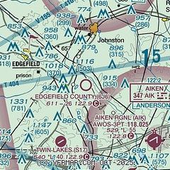
|
| Airport distance calculator |
|---|
|
|
| Sunrise and sunset |
|---|
|
Times for 13-Apr-2026
| | Local
(UTC-4) | | Zulu
(UTC) |
|---|
| Morning civil twilight | | 06:35 | | 10:35 |
| Sunrise | | 07:00 | | 11:00 |
| Sunset | | 19:56 | | 23:56 |
| Evening civil twilight | | 20:21 | | 00:21 |
|
| Current date and time |
|---|
| Zulu (UTC) | 13-Apr-2026 10:43:20 |
|---|
| Local (UTC-4) | 13-Apr-2026 06:43:20 |
|---|
|
| METAR |
|---|
KAIK
8nm SE | 131015Z AUTO 22003KT 3 1/2SM BR CLR 13/13 A3035 RMK AO2 T01330130
|
KDNL
19nm SW | 130953Z AUTO 18003KT 10SM CLR 14/13 A3033 RMK AO2 SLP267 T01440133
|
|
| TAF |
|---|
KAIK
8nm SE | 131024Z 1310/1406 17004KT P6SM SCT025 SCT200 TEMPO 1310/1312 3SM BR SCT006 BKN012 FM131500 21007KT P6SM SCT200 FM140000 18003KT P6SM FEW200
|
KDNL
19nm SW | 130840Z 1309/1406 16004KT P6SM SCT025 BKN200 FM131500 21006KT P6SM SCT200 FM140000 18003KT P6SM FEW200
|
|
| NOTAMs |
|---|
NOTAMs are issued by the DoD/FAA and will open in a separate window not controlled by AirNav.
|
|

