FAA INFORMATION EFFECTIVE 19 FEBRUARY 2026
Location
| FAA Identifier: | 7Y9 |
| Lat/Long: | 48-12-01.7111N 093-45-44.5893W
48-12.028518N 093-45.743155W
48.2004753,-93.7623859
(estimated) |
| Elevation: | 1233 ft. / 376 m (estimated) |
| Variation: | 03E (1985) |
| From city: | 3 miles NE of BIG FALLS, MN |
| Time zone: | UTC -6 (UTC -5 during Daylight Saving Time) |
| Zip code: | 56627 |
Airport Operations
| Airport use: | Open to the public |
| Activation date: | 01/1951 |
| Control tower: | no |
| ARTCC: | MINNEAPOLIS CENTER |
| FSS: | PRINCETON FLIGHT SERVICE STATION |
| NOTAMs facility: | PNM (NOTAM-D service available) |
| Attendance: | UNATNDD |
| Wind indicator: | lighted |
| Segmented circle: | no |
| Lights: | SS-SR |
Airport Communications
Nearby radio navigation aids
| VOR radial/distance | | VOR name | | Freq | | Var |
|---|
| INLr207/26.1 | | INTERNATIONAL FALLS VOR/D | | 114.95 | | 06E |
Airport Services
| Parking: | tiedowns |
| Airframe service: | NONE |
| Powerplant service: | NONE |
| Bottled oxygen: | NONE |
| Bulk oxygen: | NONE |
Runway Information
Runway 3/21
| Dimensions: | 2850 x 100 ft. / 869 x 30 m |
| Surface: | turf, in fair condition |
| Runway edge markings: | YELLOW CONES. |
| RUNWAY 3 | | RUNWAY 21 |
| Latitude: | 48-11.924978N | | 48-12.305835N |
| Longitude: | 093-45.765805W | | 093-45.356993W |
| Elevation: | 1231.6 ft. | | 1229.3 ft. |
| Traffic pattern: | left | | left |
| Runway heading: | 032 magnetic, 035 true | | 212 magnetic, 215 true |
| Displaced threshold: | no | | 816 ft. |
| Markings: | NSTD, in fair condition | | NSTD, in fair condition |
| Touchdown point: | yes, no lights | | yes, no lights |
| Obstructions: | 54 ft. trees, 581 ft. from runway, 72 ft. left of centerline, 10:1 slope to clear | | 47 ft. trees, 581 ft. from runway, 93 ft. right of centerline, 12:1 slope to clear |
Runway 11/29
| Dimensions: | 2602 x 200 ft. / 793 x 61 m |
| Surface: | turf, in fair condition |
| Runway edge lights: | non-standard
NSTD LIRL DUE TO SPACING. |
| Runway edge markings: | YELLOW CONES. |
| RUNWAY 11 | | RUNWAY 29 |
| Latitude: | 48-12.042250N | | 48-11.824447N |
| Longitude: | 093-46.217735W | | 093-45.666737W |
| Elevation: | 1229.3 ft. | | 1232.3 ft. |
| Traffic pattern: | left | | left |
| Runway heading: | 117 magnetic, 120 true | | 297 magnetic, 300 true |
| Markings: | NSTD | | NSTD |
| Touchdown point: | yes, no lights | | yes, no lights |
| Obstructions: | 48 ft. trees, 481 ft. from runway, 172 ft. left of centerline, 10:1 slope to clear | | 93 ft. trees, 1751 ft. from runway, 225 ft. right of centerline, 18:1 slope to clear |
Airport Ownership and Management from official FAA records
| Ownership: | Publicly-owned |
| Owner: | CITY OF BIG FALLS
PO BOX 196
BIG FALLS, MN 56627-0196
Phone 218-276-2282 |
| Manager: | TERRY BAIRD
PO BOX 196
BIG FALLS, MN 56627-0196
Phone 218-556-4827 |
Additional Remarks
| - | ARPT SFCS NOT PLOWED IN WINTER, FOR CONDS CALL AMGR OR CK NOTAMS. |
| - | ULTRALIGHT TFC ON & INVOF ARPT. |
| - | FOR CD CTC MINNEAPOLIS ARTCC AT 651-463-5588. |
Instrument Procedures
There are no published instrument procedures at 7Y9.
Some nearby airports with instrument procedures:
KFOZ - Bigfork Municipal Airport (25 nm S)
KINL - Falls International Airport-Einarson Field (26 nm NE)
KORB - Orr Regional Airport (38 nm E)
KBDE - Baudette International Airport (46 nm NW)
KCQM - Cook Municipal Airport (49 nm SE)
|
|

Road maps at:
MapQuest
Bing
Google
| Aerial photo |
|---|

|
| Sectional chart |
|---|
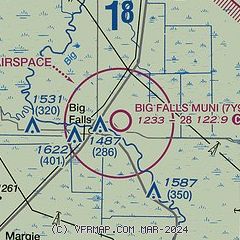
|
| Airport distance calculator |
|---|
|
|
| Sunrise and sunset |
|---|
|
Times for 23-Feb-2026
| | Local
(UTC-6) | | Zulu
(UTC) |
|---|
| Morning civil twilight | | 06:37 | | 12:37 |
| Sunrise | | 07:09 | | 13:09 |
| Sunset | | 17:48 | | 23:48 |
| Evening civil twilight | | 18:20 | | 00:20 |
|
| Current date and time |
|---|
| Zulu (UTC) | 24-Feb-2026 03:22:38 |
|---|
| Local (UTC-6) | 23-Feb-2026 21:22:38 |
|---|
|
| METAR |
|---|
KINL
26nm NE | 240254Z AUTO 16007G16KT 10SM OVC070 M09/M15 A2998 RMK AO2 PRESFR SLP186 T10891150 56050
|
KVWU
30nm W | 240255Z AUTO 16008G16KT 133V193 10SM SCT070 BKN090 OVC110 M07/M14 A2998 RMK AO2
|
KORB
38nm E | 240255Z AUTO 15011KT 10SM FEW012 BKN070 OVC085 M10/M14 A3003 RMK AO2 T11041143 58047
|
KBDE
47nm NW | 240253Z AUTO 17011G20KT 10SM BKN055 OVC065 M08/M15 A2991 RMK AO2 PRESFR SLP156 T10831150 58054 $
|
KCDD
48nm E | 240253Z AUTO 16005KT 10SM OVC070 M10/M13 A3009 RMK AO2 TSNO
|
KCQM
49nm SE | 240255Z AUTO 15009G17KT 10SM OVC070 M11/M14 A3005 RMK AO2
|
|
| TAF |
|---|
KINL
26nm NE | 231739Z 2318/2418 15007KT P6SM BKN090 FM240000 16009G18KT P6SM OVC090 FM241000 17010G20KT 5SM -SN OVC027 FM241200 18010G19KT 1 1/2SM -SN OVC017 FM241600 26010KT 5SM -SN OVC018
|
|
| NOTAMs |
|---|
NOTAMs are issued by the DoD/FAA and will open in a separate window not controlled by AirNav.
|
|

