FAA INFORMATION EFFECTIVE 14 MAY 2026
Location
| FAA Identifier: | CO00 |
| Lat/Long: | 39-16-47.9670N 103-03-59.7680W
39-16.799450N 103-03.996133W
39.2799908,-103.0666022
(estimated) |
| Elevation: | 4945 ft. / 1507.2 m (surveyed) |
| Variation: | 10E (1985) |
| From city: | 1 mile S of FLAGLER, CO |
| Time zone: | UTC -6 (UTC -7 during Standard Time) |
| Zip code: | 80815 |
Airport Operations
| Airport use: | Private use. Permission required prior to landing |
| Activation date: | 12/1944 |
| Control tower: | no |
| ARTCC: | DENVER CENTER |
| FSS: | DENVER FLIGHT SERVICE STATION |
| Attendance: | DAYLIGHT HOURS |
| Wind indicator: | yes |
| Segmented circle: | no |
| Lights: | OWNER USE ONLY. |
Nearby radio navigation aids
| VOR radial/distance | | VOR name | | Freq | | Var |
|---|
| TXCr153/26.0 | | THURMAN VORTAC | | 112.90 | | 12E |
| HGOr036/37.9 | | HUGO VOR/DME | | 112.10 | | 07E |
| NDB name | | Hdg/Dist | | Freq | | Var | | ID |
|---|
| KIT CARSON | | 267/36.4 | | 209 | | 06E | | ITR | .. - .-. |
Airport Services
| Fuel available: | 100LL |
| Parking: | tiedowns |
| Bottled oxygen: | NONE |
| Bulk oxygen: | NONE |
Runway Information
Runway 17/35
| Dimensions: | 2620 x 20 ft. / 799 x 6 m
WIDTH 160' INCLUDING GRADED TURF SHOULDERS W/ CENTER 20' ASPH. |
| Surface: | asphalt, in fair condition |
| Weight bearing capacity: | |
| Runway edge lights: | non-standard
OWNER USE ONLY. |
| RUNWAY 17 | | RUNWAY 35 |
| Traffic pattern: | left | | right |
| Runway end identifier lights: | no | | no |
| Obstructions: | 40 ft. pole, 320 ft. from runway, 150 ft. left of centerline, 3:1 slope to clear | | 15 ft. road, 400 ft. from runway, 13:1 slope to clear |
Runway 14/32
| Dimensions: | 3900 x 90 ft. / 1189 x 27 m |
| Surface: | turf, in fair condition |
| RUNWAY 14 | | RUNWAY 32 |
| Traffic pattern: | right | | left |
| Runway end identifier lights: | no | | no |
| Obstructions: | 79 ft. ant, 2514 ft. from runway, 233 ft. right of centerline, 31:1 slope to clear | | road, 600 ft. from runway, 40:1 slope to clear |
Runway 8/26
| Dimensions: | 2500 x 75 ft. / 762 x 23 m |
| Surface: | turf, in fair condition |
| RUNWAY 8 | | RUNWAY 26 |
| Traffic pattern: | left | | left |
| Runway end identifier lights: | no | | no |
| Obstructions: | 7 ft. post, 45 ft. from runway, 50 ft. left of centerline, 6:1 slope to clear | | 25 ft. bldg, 350 ft. from runway, 100 ft. left of centerline, 14:1 slope to clear |
Airport Ownership and Management from official FAA records
| Ownership: | Privately-owned |
| Owner: | DALLAS SAFFER
P.O. BOX 326
FLAGLER, CO 80815
Phone 719-765-4532 |
| Manager: | DALLAS SAFFER
P.O. BOX 326
FLAGLER, CO 80815
Phone 719-765-4532 |
Additional Remarks
| - | RWY 08/26 400' AT WESTERN END ARE ROUGH, WEST OF INTERSECTION WITH RWY 14/32. |
| - | EXTENSIVE CROP DUSTING ACTIVITY INVOF ARPT APR-SEP. |
| - | CAUTION:SMALL ANIMAL BURROWS IN ALL TURF AREAS. |
| - | PERMISSION TO LAND GRANTED WITH A PHONE CALL - LAND AT OWN RISK. |
| - | FOR CD CTC DENVER ARTCC AT 303-651-4257. |
Instrument Procedures
There are no published instrument procedures at CO00.
Some nearby airports with instrument procedures:
KLIC - Limon Municipal Airport (28 nm W)
KITR - Kit Carson County Airport (36 nm E)
2V6 - Yuma Municipal Airport (52 nm N)
KAKO - Colorado Plains Regional Airport (54 nm N)
2V5 - Wray Municipal Airport (62 nm NE)
|
|

Road maps at:
MapQuest
Bing
Google
| Aerial photo |
|---|
WARNING: Photo may not be current or correct
 Photo taken 15-Feb-2011
looking east.
Photo taken 15-Feb-2011
looking east.
Do you have a better or more recent aerial photo of Flagler Aerial Spraying Inc Airport that you would like to share? If so, please send us your photo.
|
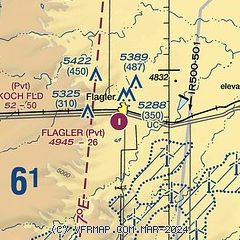
| Sectional chart |
|---|
|
| Airport distance calculator |
|---|
|
|
| Sunrise and sunset |
|---|
|
Times for 17-May-2026
| | Local
(UTC-6) | | Zulu
(UTC) |
|---|
| Morning civil twilight | | 05:08 | | 11:08 |
| Sunrise | | 05:38 | | 11:38 |
| Sunset | | 19:59 | | 01:59 |
| Evening civil twilight | | 20:30 | | 02:30 |
|
| Current date and time |
|---|
| Zulu (UTC) | 17-May-2026 23:01:35 |
|---|
| Local (UTC-6) | 17-May-2026 17:01:35 |
|---|
|
| METAR |
|---|
KLIC
28nm W | 172255Z AUTO 02022G30KT 10SM CLR 13/08 A2970 RMK AO2 PK WND 01030/2158 RAE12 SLP014 P0000 T01330083
|
KITR
36nm E | 172253Z AUTO 04033G45KT 10SM TS BKN040 BKN047 19/09 A2955 RMK AO2 PK WND 04045/2253 LTG DSNT SW-NW TSB50 PRESFR SLP969 T01890089
|
|
| NOTAMs |
|---|
NOTAMs are issued by the DoD/FAA and will open in a separate window not controlled by AirNav.
|
|

