FAA INFORMATION EFFECTIVE 20 MARCH 2025
Location
| FAA Identifier: | 5T9 |
| Lat/Long: | 28-51-25.5340N 100-30-48.4840W
28-51.425567N 100-30.808067W
28.8570928,-100.5134678
(estimated) |
| Elevation: | 887.3 ft. / 270 m (estimated) |
| Variation: | 06E (2010) |
| From city: | 8 miles N of EAGLE PASS, TX |
| Time zone: | UTC -5 (UTC -6 during Standard Time) |
| Zip code: | 78852 |
Airport Operations
| Airport use: | Open to the public |
| Activation date: | 07/1943 |
| Control tower: | no |
| ARTCC: | HOUSTON CENTER |
| FSS: | SAN ANGELO FLIGHT SERVICE STATION |
| NOTAMs facility: | SJT (NOTAM-D service available) |
| Attendance: | MON-FRI 0830-1400, ALL SAT-SUN 1000-1600 |
| Wind indicator: | lighted |
| Segmented circle: | yes |
| Lights: | DUSK-DAWN. MIRL RWY 13/31 PRESET LOW INTST; TO INCR INTST ACTVT - CTAF. |
| Beacon: | white-green (lighted land airport)
Operates sunset to sunrise. |
| International operations: | international airport of entry |
Airport Communications
| CTAF/UNICOM: | 122.8 |
| WX AWOS-3: | 119.175 (830-757-6795) |
| DEL RIO APPROACH: | 127.75 |
| DEL RIO DEPARTURE: | 127.75 |
- APCH/DEP CTL SVC PRVDD BY HOUSTON ARTCC (ZHU) ON FREQS 125.75/346.4 (ROCK SPRINGS RCAG) WHEN DEL RIO APCH CTL (DLF) CLSD.
Nearby radio navigation aids
| VOR radial/distance | | VOR name | | Freq | | Var |
|---|
| DLFr149/33.1 | | LAUGHLIN VORTAC | | 114.40 | | 07E |
Airport Services
| Fuel available: | 100LL JET-A |
| Parking: | tiedowns |
| Airframe service: | NONE |
| Powerplant service: | NONE |
| Bottled oxygen: | NONE |
| Bulk oxygen: | NONE |
Runway Information
Runway 13/31
| Dimensions: | 5506 x 100 ft. / 1678 x 30 m |
| Surface: | asphalt, in poor condition
EXTSV CRACKING, VEGETATION. |
| Runway edge lights: | medium intensity |
| Runway edge markings: | RWY MRKGS FADED. AIMING POINT IN OLD RWY APPRS BFR THR. |
| RUNWAY 13 | | RUNWAY 31 |
| Latitude: | 28-51.746700N | | 28-51.104433N |
| Longitude: | 100-31.173000W | | 100-30.443133W |
| Elevation: | 887.2 ft. | | 882.2 ft. |
| Traffic pattern: | left | | left |
| Runway heading: | 129 magnetic, 135 true | | 309 magnetic, 315 true |
| Markings: | nonprecision, in poor condition | | nonprecision, in poor condition |
| Touchdown point: | yes, no lights | | yes, no lights |
| Obstructions: | 15 ft. brush, 201 ft. from runway, 220 ft. left and right of centerline
18 FT BRUSH 0-199 FT DSTC 185 FT LEFT. | | 15 ft. brush, 201 ft. from runway, 203 ft. right of centerline
18 FT BRUSH 0-199 FT DSTC, 200 FT RIGHT. |
Airport Ownership and Management from official FAA records
| Ownership: | Publicly-owned |
| Owner: | COUNTY OF MAVERICK
500 QUARRY
EAGLE PASS, TX 78852
Phone 830-773-3824 |
| Manager: | RAUL PEREZ
500 QUARRY STREET, SUITE 3
EAGLE PASS, TX 78852
Phone 830-773-9636
ARPT OFC PHONE 830-773-9636. |
Additional Remarks
| - | FLIGHT NOTIFICATION SERVICE (ADCUS) AVBL. |
| - | FOR CD CTC LAUGHLIN APCH AT 830-298-5192, WHEN APCH CLSD CTC HOUSTON ARTCC AT 281-230-5622. |
| - | TWYS - EXTSV CRACKING, LOOSE STONES, VEGETATION, NO MRKGS, NO LGTS. |
| - | RWY 31 - PAVEMENT MRKG INDCS RWY 30. |
| - | OLD RWY MKGS SHOW IN PAVED AREA APRXLY 300 FT BFR EACH RWY END. |
Instrument Procedures
NOTE: All procedures below are presented as PDF files. If you need a reader for these files, you should download the free Adobe Reader.NOT FOR NAVIGATION. Please procure official charts for flight.
FAA instrument procedures published for use from 20 March 2025 at 0901Z to 17 April 2025 at 0900z.
IAPs - Instrument Approach Procedures |
|---|
| RNAV (GPS) RWY 13 | |
download (199KB) |
| RNAV (GPS) RWY 31 | |
download (210KB) |
| NOTE: Special Take-Off Minimums/Departure Procedures apply | |
download (294KB) |
Other nearby airports with instrument procedures:
KDLF - Laughlin AFB Airport (33 nm NW)
KDRT - Del Rio International Airport (38 nm NW)
KCZT - Dimmit County Airport (41 nm SE)
KUVA - Garner Field Airport (46 nm NE)
KECU - Edwards County Airport (68 nm N)
|
|

Road maps at:
MapQuest
Bing
Google
| Aerial photo |
|---|
WARNING: Photo may not be current or correct
 Photo taken 29-Jun-2018
looking southwest.
Photo taken 29-Jun-2018
looking southwest.
Do you have a better or more recent aerial photo of Maverick County Memorial International Airport that you would like to share? If so, please send us your photo.
|
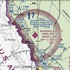
| Sectional chart |
|---|
|
| Airport distance calculator |
|---|
|
|
| Sunrise and sunset |
|---|
|
Times for 10-Apr-2025
| | Local
(UTC-5) | | Zulu
(UTC) |
|---|
| Morning civil twilight | | 06:59 | | 11:59 |
| Sunrise | | 07:23 | | 12:23 |
| Sunset | | 20:04 | | 01:04 |
| Evening civil twilight | | 20:28 | | 01:28 |
|
| Current date and time |
|---|
| Zulu (UTC) | 10-Apr-2025 22:37:36 |
|---|
| Local (UTC-5) | 10-Apr-2025 17:37:36 |
|---|
|
| METAR |
|---|
| K5T9 | 102215Z AUTO 16010KT 10SM CLR 37/03 A3000 RMK A01
|
MMPG
10nm S | 102140Z 13005KT 10SM SKC 35/07 A3003 RMK HZY
|
|
| TAF |
|---|
MMPG
10nm S | 101641Z 1018/1118 12012KT P6SM SKC FM110300 13008KT P6SM SKC TEMPO 1103/1107 13015KT FM111300 09008KT P6SM SKC FM111600 11010KT P6SM SKC
|
|
| NOTAMs |
|---|
NOTAMs are issued by the DoD/FAA and will open in a separate window not controlled by AirNav.
|
|


