FAA INFORMATION EFFECTIVE 20 MARCH 2025
Location
| FAA Identifier: | INL |
| Lat/Long: | 48-33-56.1160N 093-24-07.8450W
48-33.935267N 093-24.130750W
48.5655878,-93.4021792
(estimated) |
| Elevation: | 1184.4 ft. / 361.0 m (surveyed) |
| Variation: | 03E (1985) |
| Time zone: | UTC -5 (UTC -6 during Standard Time) |
| Zip code: | 56649 |
Airport Operations
| Airport use: | Open to the public |
| Activation date: | 03/1942 |
| Control tower: | no |
| ARTCC: | MINNEAPOLIS CENTER |
| FSS: | PRINCETON FLIGHT SERVICE STATION |
| NOTAMs facility: | INL (NOTAM-D service available) |
| Attendance: | DAYLIGHT HOURS
FOR ATTENDANT 0000-0500 CALL 218-283-2712. |
| Wind indicator: | yes |
| Segmented circle: | no |
| Lights: | ACTVT MALSR RWY 13 & 31; HIRL RWY 13/31 - CTAF. PAPI RWY 13 & 31 OPR CONSLY. |
| Beacon: | white-green (lighted land airport)
Operates sunset to sunrise. |
| Fire and rescue: | ARFF index A |
| Airline operations: | ACR OPS NA IN EXCESS OF 15 MINS BFR OR AFT SKEDD ARR/DEP TIMES WO PRIOR CDN WITH AMGR. 24 HR PPR FOR UNSKED ACR OPS GTR THAN 30 PAX SEATS - CALL AMGR. |
| International operations: | international airport of entry |
Airport Communications
| CTAF/UNICOM: | 122.8 |
| WX ASOS: | 120.0 (218-285-6156) |
- APCH/DEP SVC PRVDD BY MINNEAPOLIS ARTCC ON FREQS 120.9/377.1 (INTERNATIONAL FALLS RCAG).
Nearby radio navigation aids
| VOR radial/distance | | VOR name | | Freq | | Var |
|---|
| INL at field | | INTERNATIONAL FALLS VOR/D | | 114.95 | | 06E |
Airport Services
| Fuel available: | 100LL JET-A |
| Parking: | hangars and tiedowns |
| Bottled oxygen: | NONE |
| Bulk oxygen: | NONE |
Runway Information
Runway 13/31
| Dimensions: | 7400 x 150 ft. / 2256 x 46 m |
| Surface: | asphalt/grooved, in good condition
6400 FT OF RWY 13/31 IS GROOVED. SOUTHERN 900 FT OF RWY 13/31 (APCH END RWY 31) IS NOT GROOVED. |
| Weight bearing capacity: | | Single wheel: | 120.0 | | Double wheel: | 214.0 | | Double tandem: | 284.0 | | Dual double tandem: | 759.0 |
|
| Runway edge lights: | high intensity |
| RUNWAY 13 | | RUNWAY 31 |
| Latitude: | 48-34.370750N | | 48-33.496767N |
| Longitude: | 093-24.759300W | | 093-23.483483W |
| Elevation: | 1184.4 ft. | | 1166.4 ft. |
| Traffic pattern: | left | | left |
| Runway heading: | 133 magnetic, 136 true | | 313 magnetic, 316 true |
| Declared distances: | TORA:7400 TODA:7400 ASDA:7400 LDA:7400 | | TORA:7400 TODA:7400 ASDA:7400 LDA:7400 |
| Markings: | precision, in good condition | | precision, in good condition |
| Visual slope indicator: | 4-light PAPI on left (3.00 degrees glide path) | | 4-light PAPI on left (3.00 degrees glide path) |
| Approach lights: | MALSR: 1,400 foot medium intensity approach lighting system with runway alignment indicator lights | | MALSR: 1,400 foot medium intensity approach lighting system with runway alignment indicator lights |
| Runway end identifier lights: | no | | |
| Touchdown point: | yes, no lights | | yes, no lights |
| Instrument approach: | ILS | | ILS |
Runway 4/22
| Dimensions: | 2999 x 75 ft. / 914 x 23 m |
| Surface: | asphalt, in fair condition |
| Weight bearing capacity: | |
| Operational restrictions: | CLSD TO SKEDD ACR OPS GTR THAN 9 PAX SEATS OR UNSKED ACR OPS GTR THAN 30 PAX SEATS. CLSD AT NGT. CLSD DRG WINTER MONTHS. |
| RUNWAY 4 | | RUNWAY 22 |
| Latitude: | 48-33.755383N | | 48-34.122433N |
| Longitude: | 093-24.402217W | | 093-23.905850W |
| Elevation: | 1170.0 ft. | | 1181.1 ft. |
| Traffic pattern: | left | | left |
| Runway heading: | 039 magnetic, 042 true | | 219 magnetic, 222 true |
| Declared distances: | TORA:2999 TODA:2999 ASDA:2999 LDA:2999 | | TORA:2999 TODA:2999 ASDA:2999 LDA:2999 |
| Markings: | basic, in fair condition | | basic, in fair condition |
| Touchdown point: | yes, no lights | | yes, no lights |
Airport Ownership and Management from official FAA records
| Ownership: | Publicly-owned |
| Owner: | CITY OF INTL FALLS
PO BOX 392
INTERNATIONAL FALLS, MN 56649-0392
Phone 218-283-4461 |
| Manager: | THOR EINARSON
3214 2ND AVE E
INTERNATIONAL FALLS, MN 56649-8955
Phone 218-283-4461
THOR@EINARSONFLYING.COM. |
Additional Remarks
| A39-13/31 | PCR VALUE: 670/F/D/X/T |
| A39-04/22 | PCR VALUE: 100/F/D/X/T |
| - | GULLS & DEER ON & INVOF ARPT. |
| - | FOR CD IF UNA TO CTC ON FSS FREQ, CTC MINNEAPOLIS ARTCC AT 651-463-5588. |
| - | FLD CONDS UNMON 0000-0500, CALL 218-283-2712. |
Instrument Procedures
NOTE: All procedures below are presented as PDF files. If you need a reader for these files, you should download the free Adobe Reader.NOT FOR NAVIGATION. Please procure official charts for flight.
FAA instrument procedures published for use from 20 March 2025 at 0901Z to 17 April 2025 at 0900z.
IAPs - Instrument Approach Procedures |
|---|
| ILS OR LOC RWY 13 **CHANGED** | |
download (251KB) |
| ILS OR LOC RWY 31 **CHANGED** | |
download (241KB) |
| RNAV (GPS) RWY 13 **CHANGED** | |
download (289KB) |
| RNAV (GPS) RWY 31 **CHANGED** | |
download (283KB) |
| VOR RWY 13 **CHANGED** | |
download (213KB) |
| VOR RWY 31 **CHANGED** | |
download (180KB) |
| COPTER ILS OR LOC RWY 31 **CHANGED** | |
download (225KB) |
| NOTE: Special Alternate Minimums apply | |
download (153KB) |
| NOTE: Special Take-Off Minimums/Departure Procedures apply | |
download (404KB) |
Other nearby airports with instrument procedures:
KORB - Orr Regional Airport (40 nm SE)
KFOZ - Bigfork Municipal Airport (48 nm S)
KBDE - Baudette International Airport (49 nm W)
KCQM - Cook Municipal Airport (53 nm SE)
12D - Tower Municipal Airport (63 nm SE)
|
|

Road maps at:
MapQuest
Bing
Google
| Aerial photo |
|---|
WARNING: Photo may not be current or correct
 Photo by Vicki Eifert
Photo taken 28-May-2018
looking southeast.
Photo by Vicki Eifert
Photo taken 28-May-2018
looking southeast.
Do you have a better or more recent aerial photo of Falls International Airport-Einarson Field that you would like to share? If so, please send us your photo.
|
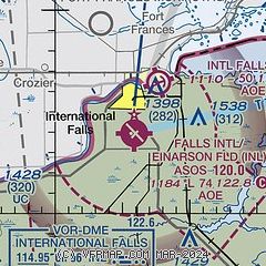
| Sectional chart |
|---|
|
| Airport distance calculator |
|---|
|
|
| Sunrise and sunset |
|---|
|
Times for 15-Apr-2025
| | Local
(UTC-5) | | Zulu
(UTC) |
|---|
| Morning civil twilight | | 05:51 | | 10:51 |
| Sunrise | | 06:24 | | 11:24 |
| Sunset | | 20:03 | | 01:03 |
| Evening civil twilight | | 20:36 | | 01:36 |
|
| Current date and time |
|---|
| Zulu (UTC) | 15-Apr-2025 09:55:15 |
|---|
| Local (UTC-5) | 15-Apr-2025 04:55:15 |
|---|
|
| METAR |
|---|
| KINL | 150854Z AUTO 32009KT 10SM FEW070 M01/M03 A2998 RMK AO2 SLP166 T10061033 53005 $
|
|
| TAF |
|---|
| KINL | 150801Z 1508/1606 32008KT P6SM BKN035 FM151700 32011G18KT P6SM BKN040 FM152100 33010KT P6SM FEW100 FM160100 VRB03KT P6SM SKC
|
|
| NOTAMs |
|---|
NOTAMs are issued by the DoD/FAA and will open in a separate window not controlled by AirNav.
|
|


