FAA INFORMATION EFFECTIVE 17 APRIL 2025
Location
| FAA Identifier: | CKC |
| Lat/Long: | 47-50-18.3540N 090-23-04.4810W
47-50.305900N 090-23.074683W
47.8384317,-90.3845781
(estimated) |
| Elevation: | 1803 ft. / 549.6 m (surveyed) |
| Variation: | 01W (1995) |
| From city: | 7 miles NW of GRAND MARAIS, MN |
| Time zone: | UTC -5 (UTC -6 during Standard Time) |
| Zip code: | 55604 |
Airport Operations
| Airport use: | Open to the public |
| Activation date: | 05/1947 |
| Control tower: | no |
| ARTCC: | MINNEAPOLIS CENTER |
| FSS: | PRINCETON FLIGHT SERVICE STATION |
| NOTAMs facility: | CKC (NOTAM-D service available) |
| Attendance: | MON-SAT 0800-1700, ALL SUN 0900-1700 |
| Wind indicator: | lighted |
| Segmented circle: | yes |
| Lights: | ACTVT OR INCR INTST REIL RWY 10 & 28; PAPI RWY 10 & 28; MIRL RWY 10/28 - CTAF. MIRL RWY 10/28 PRESET LOW INTST. |
| Beacon: | white-green (lighted land airport)
Operates sunset to sunrise. |
| International operations: | customs landing rights airport |
Airport Communications
| CTAF/UNICOM: | 122.8 |
| WX AWOS-3: | 119.925 (218-387-1971) |
- COMMUNICATIONS PRVDD BY PRINCETON RADIO ON FREQ 122.3 (GRAND MARAIS RCO).
- APCH/DEP SVC PRVDD BY MINNEAPOLIS ARTCC (ZMP) ON FREQS 127.9/281.45 (DULUTH RCAG).
Nearby radio navigation aids
| NDB name | | Hdg/Dist | | Freq | | Var | | ID |
|---|
| COOK COUNTY | | at field | | 358 | | 01W | | CKC | -.-. -.- -.-. |
Airport Services
| Fuel available: | 100LL JET-A
100LL:FOR SVC AFT HRS CALL 218-387-2012. |
| Parking: | hangars and tiedowns |
| Airframe service: | MAJOR |
| Powerplant service: | MAJOR |
Runway Information
Runway 10/28
| Dimensions: | 5002 x 100 ft. / 1525 x 30 m |
| Surface: | asphalt, in good condition |
| Runway edge lights: | medium intensity |
| RUNWAY 10 | | RUNWAY 28 |
| Latitude: | 47-50.339503N | | 47-50.272230N |
| Longitude: | 090-23.683567W | | 090-22.465820W |
| Elevation: | 1803.0 ft. | | 1793.9 ft. |
| Traffic pattern: | left | | left |
| Runway heading: | 096 magnetic, 095 true | | 276 magnetic, 275 true |
| Markings: | nonprecision, in good condition | | nonprecision, in good condition |
| Visual slope indicator: | 4-light PAPI on left (3.00 degrees glide path) | | 4-light PAPI on left (3.00 degrees glide path) |
| Runway end identifier lights: | yes | | yes |
| Touchdown point: | yes, no lights | | yes, no lights |
| Obstructions: | none
4 FT BRUSH, 95 FT DIST, 218 FT R. | | 16 ft. brush, 445 ft. from runway, 20 ft. left of centerline, 15:1 slope to clear |
Airport Ownership and Management from official FAA records
| Ownership: | Publicly-owned |
| Owner: | COOK COUNTY
411 W 2ND ST
GRAND MARAIS, MN 55604-2307
Phone 218-837-3000 |
| Manager: | RODNEY ROY
123 AIRPORT RD
GRAND MARAIS, MN 55604-2304
Phone 218-387-3024 |
Additional Remarks
| A30A-28 | CALM WIND RWY. |
| - | CUST AVBL MAY 15-OCT 15. |
| - | FOR CD IF UNA TO CTC ON FSS FREQ, CTC MINNEAPOLIS ARTCC AT 651-463-5588. |
Instrument Procedures
NOTE: All procedures below are presented as PDF files. If you need a reader for these files, you should download the free Adobe Reader.NOT FOR NAVIGATION. Please procure official charts for flight.
FAA instrument procedures published for use from 17 April 2025 at 0901Z to 15 May 2025 at 0900z.
IAPs - Instrument Approach Procedures |
|---|
| RNAV (GPS) RWY 10 | |
download (224KB) |
| RNAV (GPS) RWY 28 | |
download (227KB) |
| NOTE: Special Alternate Minimums apply | |
download (81KB) |
| NOTE: Special Take-Off Minimums/Departure Procedures apply | |
download (156KB) |
Other nearby airports with instrument procedures:
KELO - Ely Municipal Airport (58 nm W)
4R5 - Major Gilbert Field Airport (65 nm S)
KOGM - Ontonagon County Airport/Schuster Field (73 nm SE)
KTWM - Richard B Helgeson Airport (73 nm SW)
12D - Tower Municipal Airport (77 nm W)
|
|

Road maps at:
MapQuest
Bing
Google
| Aerial photo |
|---|
WARNING: Photo may not be current or correct
 Photo by Steve Sweney
Do you have a better or more recent aerial photo of Grand Marais/Cook County Airport that you would like to share? If so, please send us your photo.
|
| Sectional chart |
|---|
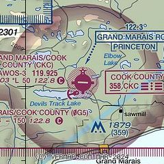
|
| Airport distance calculator |
|---|
|
|
| Sunrise and sunset |
|---|
|
Times for 06-May-2025
| | Local
(UTC-5) | | Zulu
(UTC) |
|---|
| Morning civil twilight | | 05:01 | | 10:01 |
| Sunrise | | 05:37 | | 10:37 |
| Sunset | | 20:20 | | 01:20 |
| Evening civil twilight | | 20:55 | | 01:55 |
|
| Current date and time |
|---|
| Zulu (UTC) | 06-May-2025 07:31:54 |
|---|
| Local (UTC-5) | 06-May-2025 02:31:54 |
|---|
|
| METAR |
|---|
| KCKC | 060725Z AUTO 34004KT 10SM CLR 02/M01 A3001 RMK AO2
|
KGNA
5nm S | 060656Z AUTO 08003KT 03/01 A3000 RMK AO1 SLP166 T00280006 $
|
|
| NOTAMs |
|---|
NOTAMs are issued by the DoD/FAA and will open in a separate window not controlled by AirNav.
|
|


