FAA INFORMATION EFFECTIVE 14 MAY 2026
Location
| FAA Identifier: | EZZ |
| Lat/Long: | 39-43-39.2000N 094-16-35.0000W
39-43.653333N 094-16.583333W
39.7275556,-94.2763889
(estimated) |
| Elevation: | 1040.1 ft. / 317.0 m (surveyed) |
| Variation: | 03E (2000) |
| From city: | 2 miles SW of CAMERON, MO |
| Time zone: | UTC -5 (UTC -6 during Standard Time) |
| Zip code: | 64429 |
Airport Operations
| Airport use: | Open to the public |
| Activation date: | 12/1970 |
| Control tower: | no |
| ARTCC: | KANSAS CITY CENTER |
| FSS: | COLUMBIA FLIGHT SERVICE STATION |
| NOTAMs facility: | COU (NOTAM-D service available) |
| Attendance: | MON-FRI 0900-1700, ALL SAT IREG |
| Wind indicator: | lighted |
| Segmented circle: | yes |
| Lights: | MIRL RY 17/35, PAPI RYS 17 & 35, REIL RYS 17 & 35 OPER DUSK-2400; AFT 2400 ACTVT & INCR INTS - CTAF. |
| Beacon: | white-green (lighted land airport)
Operates sunset to sunrise. |
Airport Communications
| CTAF/UNICOM: | 122.8 |
| WX AWOS-3PT: | 121.05 (816-933-2124) |
| KANSAS CITY APPROACH: | 118.4 |
| KANSAS CITY DEPARTURE: | 118.4 |
| CLEARANCE DELIVERY: | 121.6 |
Nearby radio navigation aids
| VOR radial/distance | | VOR name | | Freq | | Var |
|---|
| BQSr284/19.4 | | BRAYMER VOR/DME | | 115.35 | | 03E |
| STJr107/33.0 | | ST JOSEPH VORTAC | | 115.50 | | 08E |
| MCIr034/34.0 | | KANSAS CITY VORTAC | | 113.25 | | 05E |
| ANXr343/38.5 | | NAPOLEON VORTAC | | 115.15 | | 07E |
| NDB name | | Hdg/Dist | | Freq | | Var | | ID |
|---|
| AMAZON | | 104/30.6 | | 233 | | 04E | | AZN | .- --.. -. |
Airport Services
| Fuel available: | 100LL
100LL:AUTOMATED SELF FUEL AVBL 24 HRS. |
| Parking: | hangars and tiedowns |
Runway Information
Runway 17/35
| Dimensions: | 4000 x 75 ft. / 1219 x 23 m |
| Surface: | concrete, in good condition |
| Weight bearing capacity: | |
| Runway edge lights: | medium intensity |
| RUNWAY 17 | | RUNWAY 35 |
| Latitude: | 39-43.981517N | | 39-43.325632N |
| Longitude: | 094-16.623387W | | 094-16.542028W |
| Elevation: | 1040.1 ft. | | 1023.1 ft. |
| Traffic pattern: | left | | left |
| Runway heading: | 172 magnetic, 175 true | | 352 magnetic, 355 true |
| Markings: | nonprecision, in good condition | | nonprecision, in good condition |
| Visual slope indicator: | 4-light PAPI on left (3.00 degrees glide path) | | 4-light PAPI on left (3.00 degrees glide path) |
| Runway end identifier lights: | yes | | yes |
| Touchdown point: | yes, no lights | | yes, no lights |
| Obstructions: | 39 ft. trees, 1234 ft. from runway, 310 ft. left of centerline, 26:1 slope to clear | | none |
Airport Ownership and Management from official FAA records
| Ownership: | Publicly-owned |
| Owner: | CITY OF CAMERON
205 NORTH MAIN
CAMERON, MO 64429
Phone 816-632-2177 |
| Manager: | ERIC EVANS
11766 NORTHEAST A HWY
CAMERON, MO 64429
Phone 816-632-2423 |
Additional Remarks
| A96 | ULTRALIGHT ACTVTY ON & INVOF ARPT. |
| - | FOR CD CTC KANSAS CITY APCH AT 816-329-2710. |
Instrument Procedures
NOTE: All procedures below are presented as PDF files. If you need a reader for these files, you should download the free Adobe Reader.NOT FOR NAVIGATION. Please procure official charts for flight.
FAA instrument procedures published for use from 14 May 2026 at 0901Z to 11 June 2026 at 0900Z.
IAPs - Instrument Approach Procedures |
|---|
| RNAV (GPS) RWY 17 | |
download (199KB) |
| RNAV (GPS) RWY 35 | |
download (208KB) |
| NOTE: Special Take-Off Minimums/Departure Procedures apply | |
download (421KB) |
Other nearby airports with instrument procedures:
3EX - Excelsior Springs Memorial Airport (24 nm S)
KGPH - Midwest National Air Center Airport (24 nm S)
KSTJ - Rosecrans Memorial Airport (29 nm W)
KMCI - Kansas City International Airport (33 nm SW)
KCHT - Chillicothe Municipal Airport (36 nm E)
|
|

Road maps at:
MapQuest
Bing
Google
| Aerial photo |
|---|
WARNING: Photo may not be current or correct
 Photo taken 10-Jan-2012
looking northeast.
Photo taken 10-Jan-2012
looking northeast.
Do you have a better or more recent aerial photo of Cameron Memorial Airport that you would like to share? If so, please send us your photo.
|
| Sectional chart |
|---|
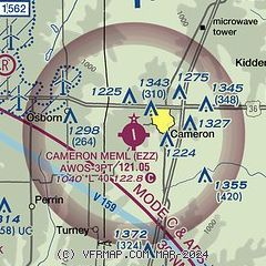
|
| Airport distance calculator |
|---|
|
|
| Sunrise and sunset |
|---|
|
Times for 01-Jun-2026
| | Local
(UTC-5) | | Zulu
(UTC) |
|---|
| Morning civil twilight | | 05:20 | | 10:20 |
| Sunrise | | 05:52 | | 10:52 |
| Sunset | | 20:38 | | 01:38 |
| Evening civil twilight | | 21:10 | | 02:10 |
|
| Current date and time |
|---|
| Zulu (UTC) | 01-Jun-2026 21:39:59 |
|---|
| Local (UTC-5) | 01-Jun-2026 16:39:59 |
|---|
|
| METAR |
|---|
| KEZZ | 012115Z AUTO 02007KT 10SM SCT047 BKN065 BKN070 31/20 A3007 RMK AO2
|
|
| TAF |
|---|
KSTJ
30nm W | 011731Z 0118/0218 06007KT P6SM SCT050
|
KMCI
33nm SW | 011731Z 0118/0218 03008KT P6SM BKN030 FM020200 07006KT P6SM FEW250
|
|
| NOTAMs |
|---|
NOTAMs are issued by the DoD/FAA and will open in a separate window not controlled by AirNav.
|
|

