FAA INFORMATION EFFECTIVE 09 JULY 2026
Location
| FAA Identifier: | GCK |
| Lat/Long: | 37-55-39.1000N 100-43-27.9000W
37-55.651667N 100-43.465000W
37.9275278,-100.7244167
(estimated) |
| Elevation: | 2890.8 ft. / 881.1 m (surveyed) |
| Variation: | 05E (2025) |
| From city: | 8 miles SE of GARDEN CITY, KS |
| Time zone: | UTC -5 (UTC -6 during Standard Time) |
| Zip code: | 67846 |
Airport Operations
| Airport use: | Open to the public |
| Activation date: | 02/1944 |
| Control tower: | yes |
| ARTCC: | KANSAS CITY CENTER |
| FSS: | WICHITA FLIGHT SERVICE STATION |
| NOTAMs facility: | GCK (NOTAM-D service available) |
| Attendance: | 0700-2100
FOR SVC AFTER HRS CALL 620-275-5055. |
| Wind indicator: | lighted |
| Segmented circle: | no |
| Lights: | ACTVT MIRL RY 12/30 & HIRL RY 17/35; REIL RYS 17; 12; 30 & MALSR RY 35 - CTAF. PAPI RYS 12 & 30 AND VASI RYS 17 & 35 ON 24 HRS. |
| Beacon: | white-green (lighted land airport)
Operates sunset to sunrise. |
| Fire and rescue: | ARFF index A |
| Airline operations: | CLSD TO UNSKED ACR OPNS WITH MORE THAN 30 PSGR SEATS EXCP PPR 48 HRS CALL AMGR (620) 276-1190/(620) 290-3810. ARFF INDEX B PROVIDED. |
Airport Communications
| CTAF: | 118.15 |
| UNICOM: | 122.95 |
| WX ASOS: | 121.325 (620-275-0803) |
| GARDEN CITY GROUND: | 119.0 254.4 [0700-2100] |
| GARDEN CITY TOWER: | 118.15 254.4 [0700-2100] |
- APCH/DEP CTL SVC PRVDD BY KANSAS CITY ARTCC (ZKC) ON FREQS 125.2/285.425 (GARDEN CITY RCAG).
Nearby radio navigation aids
| VOR radial/distance | | VOR name | | Freq | | Var |
|---|
| GCK at field | | GARDEN CITY VORTAC | | 113.30 | | 11E |
| DDCr270/34.3 | | DODGE CITY VORTAC | | 108.20 | | 08E |
Airport Services
| Fuel available: | 100LL JET-A
100LL:FOR MILITARY FUEL CALL 620-275-5055. |
| Parking: | hangars and tiedowns |
| Airframe service: | MAJOR |
| Powerplant service: | MAJOR |
| Bottled oxygen: | NONE |
| Bulk oxygen: | LOW |
Runway Information
Runway 17/35
| Dimensions: | 7299 x 100 ft. / 2225 x 30 m |
| Surface: | concrete/grooved, in good condition |
| Weight bearing capacity: | | Single wheel: | 76.0 | | Double wheel: | 91.0 | | Double tandem: | 125.0 |
|
| Runway edge lights: | high intensity |
| RUNWAY 17 | | RUNWAY 35 |
| Latitude: | 37-56.354908N | | 37-55.152413N |
| Longitude: | 100-43.369207W | | 100-43.380253W |
| Elevation: | 2888.6 ft. | | 2876.6 ft. |
| Traffic pattern: | left | | left |
| Runway heading: | 175 magnetic, 180 true | | 355 magnetic, 000 true |
| Declared distances: | TORA:7299 TODA:7299 ASDA:7299 LDA:7299 | | TORA:7299 TODA:7299 ASDA:7299 LDA:7299 |
| Markings: | nonprecision, in good condition | | precision, in good condition |
| Visual slope indicator: | 4-box VASI on left (3.00 degrees glide path) | | 4-box VASI on left (3.00 degrees glide path) |
| Approach lights: | | | MALSR: 1,400 foot medium intensity approach lighting system with runway alignment indicator lights |
| Runway end identifier lights: | yes | | |
| Touchdown point: | yes, no lights | | yes, no lights |
| Instrument approach: | | | ILS |
Runway 12/30
| Dimensions: | 5700 x 100 ft. / 1737 x 30 m |
| Surface: | concrete, in good condition |
| Weight bearing capacity: | | Single wheel: | 48.0 | | Double wheel: | 60.0 |
|
| Runway edge lights: | medium intensity |
| RUNWAY 12 | | RUNWAY 30 |
| Latitude: | 37-55.853578N | | 37-55.184692N |
| Longitude: | 100-43.996570W | | 100-43.164508W |
| Elevation: | 2890.7 ft. | | 2877.4 ft. |
| Traffic pattern: | left | | left |
| Runway heading: | 130 magnetic, 135 true | | 310 magnetic, 315 true |
| Declared distances: | TORA:5700 TODA:5700 ASDA:5700 LDA:5700 | | TORA:5700 TODA:5700 ASDA:5700 LDA:5700 |
| Markings: | nonprecision, in good condition | | nonprecision, in good condition |
| Visual slope indicator: | 2-light PAPI on left (3.00 degrees glide path) | | 2-light PAPI on left (3.00 degrees glide path) |
| Runway end identifier lights: | yes | | yes |
| Touchdown point: | yes, no lights | | yes, no lights |
Airport Ownership and Management from official FAA records
| Ownership: | Publicly-owned |
| Owner: | CITY OF GARDEN CITY
CITY HALL, BOX 499
GARDEN CITY, KS 67846
Phone 620-276-1190 |
| Manager: | MS. RACHELLE POWELL
2225 S. AIR SERVICE RD. 112
GARDEN CITY, KS 67846
Phone 620-276-1190
FAX 620-276-1192 |
Additional Remarks
| A39-12/30 | PCR VALUE: 290/R/D/W/T |
| A39-17/35 | PCR VALUE: 270/R/D/W/T |
| - | RY 35 DESIGNATED THE CALM WIND RY. |
| - | AIR CARRIER OPS ARE NOT AUTHORIZED IN EXCESS OF 15 MINUTES BEFORE OR AFTER SCHEDULED ARRIVAL/DEPARTURE TIMES WITHOUT PRIOR COORDINATION WITH AMGR AND CONFIRMATION THAT ARFF IS AVBL PRIOR TO LDNG OR TKOF. |
| - | IN THE EVENT OF AN AIR CARRIER DIVERSION OR OTHER IRREGULAR OPERATIONS EVENTS, AIRCRAFT OPERATORS SHOULD CONTACT AMGR 620-290-3810. FACILITY CONSTRAINTS INCLUDE: LACK OF INTERNATIONAL PASSENGER PROCESSING FACILITIES, LIMITED NUMBER OF PARKING POSITIONS AND LIMITED TERMINAL SPACE FOR PASSENGERS. |
| - | ATCT BLIND SPOT ON THE NORTH TWY A HOLD BAY. |
| - | FOR CD IF UNA TO CTC ON FSS FREQ, CTC KANSAS CITY ARTCC AT 913-254-8508. |
Instrument Procedures
NOTE: All procedures below are presented as PDF files. If you need a reader for these files, you should download the free Adobe Reader.NOT FOR NAVIGATION. Please procure official charts for flight.
FAA instrument procedures published for use from 09 July 2026 at 0901Z to 06 August 2026 at 0900Z.
IAPs - Instrument Approach Procedures |
|---|
| ILS OR LOC RWY 35 | |
download (266KB) |
| RNAV (GPS) RWY 12 | |
download (210KB) |
| RNAV (GPS) RWY 17 | |
download (209KB) |
| RNAV (GPS) RWY 30 | |
download (217KB) |
| RNAV (GPS) RWY 35 | |
download (239KB) |
| VOR/DME RWY 12 | |
download (203KB) |
| VOR/DME RWY 17 | |
download (226KB) |
| VOR/DME RWY 30 | |
download (236KB) |
| VOR RWY 17 | |
download (202KB) |
| VOR RWY 35 | |
download (219KB) |
| NOTE: Special Alternate Minimums apply | |
download (146KB) |
| NOTE: Special Take-Off Minimums/Departure Procedures apply | |
download (147KB) |
Other nearby airports with instrument procedures:
KTQK - Scott City Municipal Airport (34 nm N)
KULS - Ulysses Airport (36 nm SW)
KDDC - Dodge City Regional Airport (37 nm E)
K79 - Jetmore Municipal Airport (39 nm E)
KMEJ - Meade Municipal Airport (43 nm SE)
|
|

Road maps at:
MapQuest
Bing
Google
| Aerial photo |
|---|
WARNING: Photo may not be current or correct
 Photo taken 07-Sep-2007
Do you have a better or more recent aerial photo of Garden City Regional Airport that you would like to share? If so, please send us your photo.
|
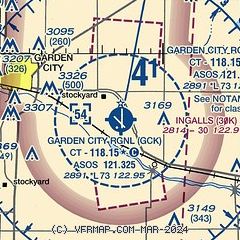
| Sectional chart |
|---|
|
CAUTION: Diagram may not be current
 Download PDF
of official airport diagram from the FAA
| Airport distance calculator |
|---|
|
|
| Sunrise and sunset |
|---|
|
Times for 14-Jul-2026
| | Local
(UTC-5) | | Zulu
(UTC) |
|---|
| Morning civil twilight | | 06:02 | | 11:02 |
| Sunrise | | 06:33 | | 11:33 |
| Sunset | | 21:05 | | 02:05 |
| Evening civil twilight | | 21:35 | | 02:35 |
|
| Current date and time |
|---|
| Zulu (UTC) | 14-Jul-2026 15:36:11 |
|---|
| Local (UTC-5) | 14-Jul-2026 10:36:11 |
|---|
|
| METAR |
|---|
| KGCK | 141454Z 20009KT 10SM CLR 26/19 A3022 RMK AO2 SLP196 T02610194 50001
|
|
| TAF |
|---|
| KGCK | 141120Z 1412/1512 14007KT P6SM SKC FM141700 13011G18KT P6SM SCT100 FM142300 13009KT P6SM SKC
|
|
| NOTAMs |
|---|
NOTAMs are issued by the DoD/FAA and will open in a separate window not controlled by AirNav.
|
|


