FAA INFORMATION EFFECTIVE 09 JULY 2026
Location
| FAA Identifier: | THA |
| Lat/Long: | 35-22-48.4510N 086-14-48.4020W
35-22.807517N 086-14.806700W
35.3801253,-86.2467783
(estimated) |
| Elevation: | 1084 ft. / 330.4 m (surveyed) |
| Variation: | 03W (2005) |
| From city: | 2 miles NW of TULLAHOMA, TN |
| Time zone: | UTC -5 (UTC -6 during Standard Time) |
| Zip code: | 37360 |
Airport Operations
| Airport use: | Open to the public |
| Activation date: | 10/1942 |
| Control tower: | no |
| ARTCC: | MEMPHIS CENTER |
| FSS: | NASHVILLE FLIGHT SERVICE STATION |
| NOTAMs facility: | BNA (NOTAM-D service available) |
| Attendance: | 0800-1800 |
| Wind indicator: | yes |
| Segmented circle: | yes |
| Lights: | ACTVT ODALS RWY 06; PAPI RWY 18 & 36; MIRL RWY 18/36 - CTAF. MIRL RWY 06/24 PRESET TO LOW INTST; INCR INTST - CTAF. |
| Beacon: | white-green (lighted land airport)
Operates sunset to sunrise. |
Airport Communications
| CTAF/UNICOM: | 123.0 |
| WX AWOS-3: | 128.325 (931-454-2052) |
| WX AWOS-3 at SYI (14 nm NW): | 119.275 (931-685-4723) |
| WX AWOS-3 at BGF (15 nm SE): | 121.675 (931-967-8445) |
- APCH/DEP SVC PRVDD BY MEMPHIS ARTCC ON FREQS 128.15/323.125 (SHELBYVILLE RCAG).
Nearby radio navigation aids
| VOR radial/distance | | VOR name | | Freq | | Var |
|---|
| SYIr140/14.4 | | SHELBYVILLE VOR/DME | | 113.55 | | 01W |
| RQZr027/39.8 | | ROCKET VORTAC | | 112.20 | | 02E |
Airport Services
| Fuel available: | 100 JET-A |
| Parking: | hangars and tiedowns |
| Airframe service: | MAJOR |
| Powerplant service: | MAJOR |
Runway Information
Runway 6/24
| Dimensions: | 5501 x 100 ft. / 1677 x 30 m |
| Surface: | asphalt/concrete, in good condition |
| Weight bearing capacity: | | PCN 29 /F/C/X/T | | Single wheel: | 76.0 | | Double wheel: | 100.0 |
|
| Runway edge lights: | medium intensity |
| RUNWAY 6 | | RUNWAY 24 |
| Latitude: | 35-22.663933N | | 35-23.147252N |
| Longitude: | 086-15.344365W | | 086-14.407622W |
| Elevation: | 1083.9 ft. | | 1077.7 ft. |
| Traffic pattern: | left | | left |
| Runway heading: | 061 magnetic, 058 true | | 241 magnetic, 238 true |
| Displaced threshold: | no | | 500 ft. |
| Markings: | nonprecision, in good condition | | nonprecision, in good condition |
| Visual slope indicator: | 2-light PAPI on left (3.00 degrees glide path) | | 2-light PAPI on left (3.00 degrees glide path) |
| Approach lights: | ODALS: omnidirectional approach lighting system | | |
| Runway end identifier lights: | yes | | yes |
| Touchdown point: | yes, no lights | | yes, no lights |
| Obstructions: | 44 ft. tree, 1064 ft. from runway, 181 ft. right of centerline, 19:1 slope to clear | | 45 ft. tree, 837 ft. from runway, 152 ft. left of centerline, 14:1 slope to clear |
Runway 18/36
| Dimensions: | 4205 x 100 ft. / 1282 x 30 m |
| Surface: | asphalt/concrete, in fair condition |
| Weight bearing capacity: | |
| Runway edge lights: | medium intensity |
| Runway edge markings: | FADED & PEELING. |
| RUNWAY 18 | | RUNWAY 36 |
| Latitude: | 35-23.285363N | | 35-22.592293N |
| Longitude: | 086-14.614020W | | 086-14.611775W |
| Elevation: | 1078.8 ft. | | 1081.7 ft. |
| Traffic pattern: | left | | left |
| Runway heading: | 183 magnetic, 180 true | | 003 magnetic, 000 true |
| Markings: | nonprecision, in poor condition | | nonprecision, in poor condition |
| Visual slope indicator: | 2-light PAPI on left (2.95 degrees glide path) | | 2-light PAPI on left (3.00 degrees glide path)
UNUSBL BYD 7 DEGS LEFT AND RIGHT OF CNTRLN. |
| Runway end identifier lights: | yes | | yes |
| Touchdown point: | yes, no lights | | yes, no lights |
| Instrument approach: | SDF | | |
| Obstructions: | 80 ft. tree, 1555 ft. from runway, 385 ft. right of centerline, 16:1 slope to clear | | 85 ft. tree, 1359 ft. from runway, 351 ft. right of centerline, 13:1 slope to clear |
Runway 9/27
| Dimensions: | 3130 x 100 ft. / 954 x 30 m |
| Surface: | turf, in good condition |
| Operational restrictions: | FICON SOFT SFC WHEN WET. |
| RUNWAY 9 | | RUNWAY 27 |
| Latitude: | 35-22.452603N | | 35-22.457772N |
| Longitude: | 086-15.345907W | | 086-14.716012W |
| Elevation: | 1077.0 ft. | | 1075.1 ft. |
| Traffic pattern: | right | | left |
| Runway heading: | 092 magnetic, 089 true | | 272 magnetic, 269 true |
| Markings: | basic, in good condition | | basic, in good condition |
| Touchdown point: | yes, no lights | | yes, no lights |
| Obstructions: | 74 ft. tree, 1322 ft. from runway, 209 ft. left of centerline, 17:1 slope to clear | | 55 ft. tree, 1040 ft. from runway, 46 ft. left of centerline, 18:1 slope to clear |
Runway N/S
| Dimensions: | 2083 x 100 ft. / 635 x 30 m |
| Surface: | turf |
| RUNWAY N | | RUNWAY S |
| Latitude: | 35-22.641157N | | 35-22.984433N |
| Longitude: | 086-14.677137W | | 086-14.678453W |
| Elevation: | 1079.6 ft. | | 1079.8 ft. |
| Traffic pattern: | left | | left |
| Runway heading: | 003 magnetic, 360 true | | 183 magnetic, 180 true |
| Touchdown point: | yes, no lights | | yes, no lights |
| Obstructions: | 92 ft. tree, 2713 ft. from runway, 399 ft. right of centerline, 29:1 slope to clear | | 77 ft. tree, 2174 ft. from runway, 373 ft. right of centerline, 28:1 slope to clear |
Airport Ownership and Management from official FAA records
| Ownership: | Publicly-owned |
| Owner: | CITY OF TULLAHOMA
BOX 1584
TULLAHOMA, TN 37388 |
| Manager: | JON GLASS
P.O. BOX 1584
TULLAHOMA, TN 37388
Phone 931-455-3884 |
Additional Remarks
| A30A-36 | 26:1 TO DTHR. |
| A30A-24 | 26:1 TO DTHR. |
| - | PAJA, GLIDER OPS, GEESE & DEER ON & INVOF ARPT; PAJA LNDG ZONE E OF PAVED RWY 18/36 MIDFIELD. |
| - | FOR CD CTC MEMPHIS ARTCC AT 901-368-8453/8449. |
Instrument Procedures
NOTE: All procedures below are presented as PDF files. If you need a reader for these files, you should download the free Adobe Reader.NOT FOR NAVIGATION. Please procure official charts for flight.
FAA instrument procedures published for use from 09 July 2026 at 0901Z to 06 August 2026 at 0900Z.
IAPs - Instrument Approach Procedures |
|---|
| RNAV (GPS) RWY 06 | |
download (252KB) |
| RNAV (GPS) RWY 18 | |
download (233KB) |
| RNAV (GPS) RWY 24 | |
download (242KB) |
| RNAV (GPS) RWY 36 | |
download (252KB) |
| NOTE: Special Alternate Minimums apply | |
download (162KB) |
| NOTE: Special Take-Off Minimums/Departure Procedures apply | |
download (363KB) |
Other nearby airports with instrument procedures:
KAYX - Arnold Air Force Base (8 nm E)
KSYI - Bomar Field/Shelbyville Municipal Airport (14 nm NW)
KBGF - Winchester Municipal Airport (15 nm SE)
KFYM - Fayetteville Municipal Airport (25 nm SW)
KRNC - Warren County Memorial Airport (27 nm NE)
|
|

Road maps at:
MapQuest
Bing
Google
| Aerial photo |
|---|
WARNING: Photo may not be current or correct
 Photo taken 10-Nov-2008
looking north.
Photo taken 10-Nov-2008
looking north.
Do you have a better or more recent aerial photo of Tullahoma Regional Airport/William Northern Field that you would like to share? If so, please send us your photo.
|
| Sectional chart |
|---|
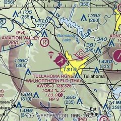
|
| Airport distance calculator |
|---|
|
|
| Sunrise and sunset |
|---|
|
Times for 31-Jul-2026
| | Local
(UTC-5) | | Zulu
(UTC) |
|---|
| Morning civil twilight | | 05:26 | | 10:26 |
| Sunrise | | 05:54 | | 10:54 |
| Sunset | | 19:49 | | 00:49 |
| Evening civil twilight | | 20:17 | | 01:17 |
|
| Current date and time |
|---|
| Zulu (UTC) | 31-Jul-2026 16:22:24 |
|---|
| Local (UTC-5) | 31-Jul-2026 11:22:24 |
|---|
|
| METAR |
|---|
| KTHA | 311555Z AUTO VRB03KT 10SM CLR 27/17 A3003 RMK A01
|
KSYI
14nm NW | 311555Z AUTO 00000KT 10SM CLR 28/17 A3002 RMK A01
|
KBGF
15nm SE | 311555Z AUTO VRB04KT 10SM CLR 28/18 A3004 RMK A01
|
|
| NOTAMs |
|---|
NOTAMs are issued by the DoD/FAA and will open in a separate window not controlled by AirNav.
|
|


