FAA INFORMATION EFFECTIVE 25 DECEMBER 2025
Location
| FAA Identifier: | UTS |
| Lat/Long: | 30-44-48.8000N 095-35-13.8000W
30-44.813333N 095-35.230000W
30.7468889,-95.5871667
(estimated) |
| Elevation: | 362.9 ft. / 110.6 m (surveyed) |
| Variation: | 06E (1990) |
| From city: | 2 miles NW of HUNTSVILLE, TX |
| Time zone: | UTC -6 (UTC -5 during Daylight Saving Time) |
| Zip code: | 77320 |
Airport Operations
| Airport use: | Open to the public |
| Control tower: | no |
| ARTCC: | HOUSTON CENTER |
| FSS: | MONTGOMERY COUNTY FLIGHT SERVICE STATION |
| NOTAMs facility: | UTS (NOTAM-D service available) |
| Attendance: | DAWN-DUSK |
| Wind indicator: | lighted |
| Segmented circle: | yes |
| Lights: | DUSK-DAWN. MIRL RWY 18/36 PRESET LOW INTST; TO INCR INTST & ACTVT REIL RWYS 18 & 36 - CTAF. |
| Beacon: | white-green (lighted land airport)
Operates sunset to sunrise. |
Airport Communications
| CTAF/UNICOM: | 122.8 |
| WX ASOS: | 119.425 (936-291-7997) |
- COMMUNICATIONS PRVDD BY MONTGOMERY COUNTY FSS ON FREQ 122.2.
- APCH/DEP CTL SVC PRVDD BY HOUSTON ARTCC (ZHU) ON FREQS 134.8/269.6 (LUFKIN/A RCAG).
Nearby radio navigation aids
| VOR radial/distance | | VOR name | | Freq | | Var |
|---|
| LOAr131/29.9 | | LEONA VORTAC | | 110.80 | | 08E |
| TNVr034/36.7 | | NAVASOTA VOR/DME | | 115.90 | | 08E |
Airport Services
| Fuel available: | 100LL JET-A JET-A+ |
| Parking: | hangars and tiedowns |
| Airframe service: | MAJOR |
| Powerplant service: | MAJOR |
| Bottled oxygen: | NONE |
| Bulk oxygen: | HIGH |
Runway Information
Runway 18/36
| Dimensions: | 5005 x 100 ft. / 1526 x 30 m |
| Surface: | asphalt, in poor condition
PVMT EXTSV CRACKING, SFC SPALLING, VEGETATION GROWING THROUGH. |
| Weight bearing capacity: | |
| Runway edge lights: | medium intensity |
| RUNWAY 18 | | RUNWAY 36 |
| Latitude: | 30-45.223670N | | 30-44.402345N |
| Longitude: | 095-35.181205W | | 095-35.277487W |
| Elevation: | 299.4 ft. | | 362.3 ft. |
| Traffic pattern: | left | | left |
| Runway heading: | 180 magnetic, 186 true | | 000 magnetic, 006 true |
| Markings: | nonprecision, in good condition | | nonprecision, in good condition |
| Visual slope indicator: | 4-light PAPI on left (3.00 degrees glide path) | | 4-light PAPI on left (3.00 degrees glide path) |
| Runway end identifier lights: | yes | | yes |
| Touchdown point: | yes, no lights | | yes, no lights |
| Obstructions: | 30 ft. trees, 201 ft. from runway, 175 ft. right of centerline
10-30 FT BRUSH & TREES 0-199 FT DSTC, 175 FT RIGHT. | | 45 ft. pole, 1135 ft. from runway, 195 ft. right of centerline, 20:1 slope to clear |
Airport Ownership and Management from official FAA records
| Ownership: | Publicly-owned |
| Owner: | CITY OF HUNTSVILLE
1212 AVENUE M
HUNTSVILLE, TX 77340
Phone 936-291-5401 |
| Manager: | KEVIN BYAL
448 SH 75 NORTH
HUNTSVILLE, TX 77340
Phone 936-295-8136
ON SITE ATTENDANT. |
Additional Remarks
| - | FOR CD IF UNA TO CTC ON FSS FREQ, CTC HOUSTON ARTCC AT 281-230-5622. |
Instrument Procedures
NOTE: All procedures below are presented as PDF files. If you need a reader for these files, you should download the free Adobe Reader.NOT FOR NAVIGATION. Please procure official charts for flight.
FAA instrument procedures published for use from 25 December 2025 at 0901z to 22 January 2026 at 0900z.
IAPs - Instrument Approach Procedures |
|---|
| RNAV (GPS) RWY 18 | |
download (259KB) |
| VOR/DME-A | |
download (174KB) |
| NOTE: Special Alternate Minimums apply | |
download (125KB) |
| NOTE: Special Take-Off Minimums/Departure Procedures apply | |
download (211KB) |
Other nearby airports with instrument procedures:
51R - Madisonville Municipal Airport (21 nm NW)
KCXO - Conroe/North Houston Regional Airport (25 nm S)
00R - Livingston Municipal Airport (30 nm E)
KDKR - Houston County Airport (35 nm N)
60R - Navasota Municipal Airport (35 nm SW)
|
|

Road maps at:
MapQuest
Bing
Google
| Aerial photo |
|---|
WARNING: Photo may not be current or correct
 Photo by Yasmina Platt
Photo taken 14-Aug-2014
looking north.
Photo by Yasmina Platt
Photo taken 14-Aug-2014
looking north.
Do you have a better or more recent aerial photo of Huntsville Municipal Airport that you would like to share? If so, please send us your photo.
|
| Sectional chart |
|---|
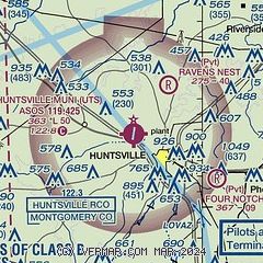
|
| Airport distance calculator |
|---|
|
|
| Sunrise and sunset |
|---|
|
Times for 14-Jan-2026
| | Local
(UTC-6) | | Zulu
(UTC) |
|---|
| Morning civil twilight | | 06:56 | | 12:56 |
| Sunrise | | 07:22 | | 13:22 |
| Sunset | | 17:41 | | 23:41 |
| Evening civil twilight | | 18:07 | | 00:07 |
|
| Current date and time |
|---|
| Zulu (UTC) | 14-Jan-2026 22:59:37 |
|---|
| Local (UTC-6) | 14-Jan-2026 16:59:37 |
|---|
|
| METAR |
|---|
| KUTS | 142253Z AUTO 34016G25KT 10SM CLR 17/02 A3007 RMK AO1 PK WND 32032/2155 SLP181 T01670022 $
|
|
| TAF |
|---|
| KUTS | 141730Z 1418/1518 35015G24KT P6SM SKC FM141900 34015G26KT P6SM SKC FM150000 34010G22KT P6SM SKC
|
|
| NOTAMs |
|---|
NOTAMs are issued by the DoD/FAA and will open in a separate window not controlled by AirNav.
|
|

