FAA INFORMATION EFFECTIVE 09 JULY 2026
The information below comes from the U.S. Federal Aviation Administration (FAA). The FAA is not the official source of data for facilities located outside the United States, and THESE RECORDS ARE LIKELY NOT COMPLETE OR CORRECT.
Location
| FAA Identifier: | MYAT |
| Lat/Long: | 26-44-43.2300N 077-23-28.5800W
26-44.720500N 077-23.476333W
26.7453417,-77.3912722
(estimated) |
| Elevation: | 10 ft. / 3 m (estimated) |
| Variation: | 08W (2010) |
| From city: | 7 miles NW of TREASURE CAY, |
| Time zone: | UTC -4 (UTC -5 during Standard Time) |
Airport Operations
| Airport use: | Open to the public, FOREIGN CIV GOVT. LNDG FEES AND DIPLOMATIC CLNC MAY BE RQR. |
| Control tower: | no |
| ARTCC: | MIAMI CENTER |
| FSS: | MIAMI FLIGHT SERVICE STATION
NASSAU FLT SVC FOR LCL INFO 1-242-377-7116/2006; EMERG 1-242-377-2040. |
| Attendance: | MON-FRI 1400-2200Z++ UTC-5(-4DT) |
| Segmented circle: | no |
| Lights: | SS-SR |
Airport Communications
- APCH/DEP SVC PRVDD BY NASSAU APCH FREQ 121.0.
- NASSAU RADIO FREQ 128.0/PRIM & 124.2/SECONDARY AVBL.
Nearby radio navigation aids
| VOR radial/distance | | VOR name | | Freq | | Var |
|---|
| ZTC at field | | TREASURE CAY VOR/DME | | 112.90 | | 05W |
Airport Services
Runway Information
Runway 14/32
| Dimensions: | 7001 x 150 ft. / 2134 x 46 m |
| Surface: | asphalt |
| Weight bearing capacity: | |
| Runway edge lights: | medium intensity |
| RUNWAY 14 | | RUNWAY 32 |
| Latitude: | 26-45.115833N | | 26-44.325167N |
| Longitude: | 077-23.945667W | | 077-23.007000W |
| Elevation: | 10.0 ft. | | 10.0 ft. |
| Traffic pattern: | left | | left |
| Runway heading: | 141 magnetic, 133 true | | 321 magnetic, 313 true |
| Declared distances: | TORA:7001 TODA:7001 LDA:7001 | | TORA:7001 TODA:7001 LDA:7001 |
| Visual slope indicator: | 2-light PAPI on left (3.25 degrees glide path)
PAPI ON LEFT. | | 2-light PAPI on left (3.25 degrees glide path)
PAPI ON LEFT. |
| Approach lights: | MALSF: 1,400 foot medium intensity approach lighting system with sequenced flashers | | |
| Runway end identifier lights: | yes | | yes |
| Touchdown point: | yes, lighted | | yes, lighted |
Airport Ownership and Management from official FAA records
| Ownership: | Publicly-owned
FOREIGN CIV GOVT. LNDG FEES AND DIPLOMATIC CLNC MAY BE RQR. |
| Manager: | DEPARTMENT OF CIVIL AVIATION
Phone 800-242-367-5500 |
Additional Remarks
| - | FIREFIGHT EQUIP AVBL: OSHKOSH, 1,500 GALS WATER, 205 GALS FOAM (6% AFFF), 500 LB DRY CHM. |
| - | CUSTOMS AND IMMIGRATION ALL MONTHS, ALL DAYS, 1400-2200Z++ UTC-5(-4DT), OTH HR ON REQ. |
Instrument Procedures
There are no published instrument procedures at MYAT.
|
|
| Aerial photo |
|---|
WARNING: Photo may not be current or correct
 Photo by Bob & Denise Hensel
Photo taken 17-Mar-2015
looking south.
Photo by Bob & Denise Hensel
Photo taken 17-Mar-2015
looking south.
Do you have a better or more recent aerial photo of Treasure Cay Airport that you would like to share? If so, please send us your photo.
|
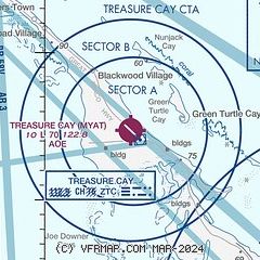
| Sectional chart |
|---|
|
| Airport distance calculator |
|---|
|
|
| Sunrise and sunset |
|---|
|
Times for 24-Jul-2026
| | Local
(UTC-4) | | Zulu
(UTC) |
|---|
| Morning civil twilight | | 06:06 | | 10:06 |
| Sunrise | | 06:31 | | 10:31 |
| Sunset | | 20:01 | | 00:01 |
| Evening civil twilight | | 20:26 | | 00:26 |
|
| Current date and time |
|---|
| Zulu (UTC) | 24-Jul-2026 21:07:22 |
|---|
| Local (UTC-4) | 24-Jul-2026 17:07:22 |
|---|
|
| NOTAMs |
|---|
NOTAMs are issued by the DoD/FAA and will open in a separate window not controlled by AirNav.
|
|

