FAA INFORMATION EFFECTIVE 16 APRIL 2026
The information below comes from the U.S. Federal Aviation Administration (FAA). The FAA is not the official source of data for facilities located outside the United States, and THESE RECORDS ARE LIKELY NOT COMPLETE OR CORRECT.
Location
| FAA Identifier: | MYNN |
| Lat/Long: | 25-02-20.8120N 077-27-58.9237W
25-02.346867N 077-27.982062W
25.0391144,-77.4663677
(estimated) |
| Elevation: | 16 ft. / 5 m (estimated) |
| Variation: | 08W (2010) |
| From city: | 7 miles W of NASSAU, |
| Time zone: | UTC -4 (UTC -5 during Standard Time) |
Airport Operations
| Airport use: | Open to the public, FOREIGN CIV GOVT. LNDG FEES AND DIPLOMATIC CLNC MAY BE RQR. |
| Control tower: | yes |
| ARTCC: | MIAMI CENTER |
| FSS: | MIAMI FLIGHT SERVICE STATION
NASSAU FLT SVC FOR LCL INFO 1-242-377-7116/2006; EMERG 1-242-377-2040. |
| Attendance: | CONTINUOUS |
| Segmented circle: | no |
| Beacon: | white-green (lighted land airport) |
Airport Communications
| UNICOM: | 122.8 |
| ATIS: | 118.7 |
| NASSAU GROUND: | 121.7 |
| NASSAU TOWER: | 119.5 134.55 |
| APPROACH: | 125.3 |
| DEPARTURE: | 125.3 |
| CLEARANCE DELIVERY: | 118.3 |
- APCH/DEP SVC PRVDD BY NASSAU APCH 121.0/PRIM & 125.3/SECONDARY (RADAR).
Nearby radio navigation aids
| VOR radial/distance | | VOR name | | Freq | | Var |
|---|
| ZQAr313/1.4 | | NASSAU VOR/DME | | 112.70 | | 06W |
Airport Services
| Fuel available: | 100LL JET-A1 |
Runway Information
Runway 14/32
| Dimensions: | 11107 x 150 ft. / 3385 x 46 m |
| Surface: | asphalt |
| Weight bearing capacity: | |
| Runway edge lights: | medium intensity |
| RUNWAY 14 | | RUNWAY 32 |
| Latitude: | 25-03.129667N | | 25-01.840000N |
| Longitude: | 077-28.559500W | | 077-27.128667W |
| Elevation: | 12.0 ft. | | 14.0 ft. |
| Traffic pattern: | left | | left |
| Runway heading: | 143 magnetic, 135 true | | 323 magnetic, 315 true |
| Displaced threshold: | 186 ft. | | no |
| Declared distances: | TORA:11353 TODA:11353 ASDA:11353 LDA:11143 | | TORA:11353 TODA:11353 ASDA:11353 LDA:11353 |
| Visual slope indicator: | 4-light PAPI on left (3.00 degrees glide path) | | 4-light PAPI on left (3.00 degrees glide path) |
| Approach lights: | SSALS: simplified short approach lighting system | | |
| Touchdown point: | yes, no lights | | yes, no lights |
Runway 9/27
| Dimensions: | 8273 x 150 ft. / 2522 x 46 m |
| Surface: | asphalt |
| Weight bearing capacity: | |
| Runway edge lights: | medium intensity |
| RUNWAY 9 | | RUNWAY 27 |
| Latitude: | 25-02.157333N | | 25-02.166167N |
| Longitude: | 077-28.916667W | | 077-27.417500W |
| Elevation: | 14.0 ft. | | 13.0 ft. |
| Traffic pattern: | left | | left |
| Runway heading: | 098 magnetic, 090 true | | 278 magnetic, 270 true |
| Declared distances: | TORA:8273 TODA:8273 ASDA:8273 LDA:8273 | | TORA:8273 TODA:8273 ASDA:8273 LDA:8273 |
| Visual slope indicator: | 4-light PAPI on left (3.00 degrees glide path) | | 4-light PAPI on left (3.00 degrees glide path) |
| Approach lights: | SSALS: simplified short approach lighting system
NSTD. | | |
| Touchdown point: | yes, no lights | | yes, no lights |
Airport Ownership and Management from official FAA records
| Ownership: | Publicly-owned |
| Manager: | NASSAU AIRPORT DEVELOPMENT COMPANY
Phone 800-242-702-1000 |
Additional Remarks
| - | FIREFIGHT EQUIP: OSHKOSH, 3,000 GALS WATER, 420 GALS FOAM, 500 LBS DRY CHM; OSHKOSH, 1,500 GALS WATER, 210 GALS FOAM, 500 LBS DRY CHM; OSHKOSH, 1,500 GALS WATER, 210 GALS FOAM, 500 LBS DRY CHM; OSHKOSH, 1,500 GALS WATER, 210 GALS FOAM; FORD, 300 GALS WATER, 20 GALS FOAM, 500 LBS DRY CHM AVBL. |
| - | TWR HAS LTD VIS OF ACFT ON APRON 1 & STANDS 56-59. |
Instrument Procedures
There are no published instrument procedures at MYNN.
|
|
| Aerial photo |
|---|
WARNING: Photo may not be current or correct
 Photo by Vicki Eifert
Photo taken 09-Nov-2018
looking northeast.
Photo by Vicki Eifert
Photo taken 09-Nov-2018
looking northeast.
Do you have a better or more recent aerial photo of Lynden Pindling International Airport that you would like to share? If so, please send us your photo.
|
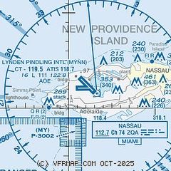
| Sectional chart |
|---|
|
CAUTION: Diagram may not be current

| Airport distance calculator |
|---|
|
|
| Sunrise and sunset |
|---|
|
Times for 23-Apr-2026
| | Local
(UTC-4) | | Zulu
(UTC) |
|---|
| Morning civil twilight | | 06:18 | | 10:18 |
| Sunrise | | 06:41 | | 10:41 |
| Sunset | | 19:35 | | 23:35 |
| Evening civil twilight | | 19:59 | | 23:59 |
|
| Current date and time |
|---|
| Zulu (UTC) | 23-Apr-2026 22:36:10 |
|---|
| Local (UTC-4) | 23-Apr-2026 18:36:10 |
|---|
|
| METAR |
|---|
| MYNN | 232200Z 13010KT 100V160 9999 FEW030 SCT040 24/15 A3001
|
|
| TAF |
|---|
| MYNN | 231700Z 2318/2418 09009KT 9999 FEW020 BKN250 BECMG 2409/2411 FEW030 SCT045 BKN130
|
|
| NOTAMs |
|---|
NOTAMs are issued by the DoD/FAA and will open in a separate window not controlled by AirNav.
|
|


