FAA INFORMATION EFFECTIVE 27 NOVEMBER 2025
Location
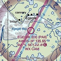
| FAA Identifier: | EII |
| Lat/Long: | 58-11-07.7650N 157-22-31.5400W
58-11.129417N 157-22.525667W
58.1854903,-157.3754278
(estimated) |
| Elevation: | 92.3 ft. / 28.1 m (surveyed) |
| Variation: | 13E (2020) |
| From city: | 2 miles S of EGEGIK, AK |
| Time zone: | UTC -9 (UTC -8 during Daylight Saving Time) |
Airport Operations
| Airport use: | Open to the public |
| Activation date: | 09/1994 |
| Control tower: | no |
| ARTCC: | ANCHORAGE CENTER |
| FSS: | KENAI FLIGHT SERVICE STATION [907-283-7211] |
| NOTAMs facility: | EII (NOTAM-D service available) |
| Attendance: | UNATNDD |
| Wind indicator: | lighted |
| Segmented circle: | yes |
| Lights: | ACTVT REIL RWY 12; PAPI RWY 12; MIRL RWY 03/21 & 12/30 - CTAF. |
| Beacon: | white-green (lighted land airport)
ACTVT ROTG BCN - CTAF. |
Airport Communications
| CTAF: | 122.8 |
| WX AWOS-3P: | 135.65 (907-233-2288) |
- APCH/DEP SVC PRVDD BY ANCHORAGE ARTCC (ZAN) ON FREQS 124.8/354.0 ( KING SALMON RCAG.)
Nearby radio navigation aids
| VOR radial/distance | | VOR name | | Freq | | Var |
|---|
| AKNr195/37.8 | | KING SALMON VORTAC | | 112.80 | | 16E |
Airport Services
Runway Information
Runway 12/30
| Dimensions: | 5600 x 100 ft. / 1707 x 30 m |
| Surface: | gravel, in good condition
RWY SURFACE SOFT WHEN WET. WATER PONDING AFTER RAIN. SAFETY AREAS BEYOND THLDS AND RWY EDGES VERY SOFT. |
| Runway edge lights: | medium intensity |
| RUNWAY 12 | | RUNWAY 30 |
| Latitude: | 58-11.478167N | | 58-10.776667N |
| Longitude: | 157-23.141167W | | 157-22.015667W |
| Elevation: | 80.7 ft. | | 92.3 ft. |
| Traffic pattern: | left | | left |
| Runway heading: | 127 magnetic, 140 true | | 307 magnetic, 320 true |
| Markings: | , in fair condition | | , in fair condition |
| Visual slope indicator: | 4-light PAPI on left (3.00 degrees glide path) | | |
| Runway end identifier lights: | yes | | |
| Touchdown point: | yes, no lights | | yes, no lights |
| Obstructions: | 8 ft. brush, 245 ft. left and right of centerline | | 6 ft. brush, 245 ft. left and right of centerline |
Runway 3/21
| Dimensions: | 1500 x 75 ft. / 457 x 23 m |
| Surface: | gravel/dirt, in good condition
RWY SURFACE SOFT AFTER RAINS. SAFETY AREAS BEYOND THLDS AND RWY EDGES VERY SOFT. |
| Runway edge lights: | medium intensity |
| RUNWAY 3 | | RUNWAY 21 |
| Latitude: | 58-11.057333N | | 58-11.216500N |
| Longitude: | 157-22.506500W | | 157-22.150833W |
| Elevation: | 80.2 ft. | | 78.7 ft. |
| Traffic pattern: | left | | left |
| Runway heading: | 037 magnetic, 050 true | | 217 magnetic, 230 true |
| Touchdown point: | yes, no lights | | yes, no lights |
| Obstructions: | 7 ft. brush, 10 ft. from runway, 125 ft. left of centerline | | 2 ft. brush, 7 ft. from runway, 100 ft. left of centerline |
Airport Ownership and Management from official FAA records
| Ownership: | Publicly-owned |
| Owner: | CITY OF EGEGIK
PO BOX 189
EGEGIK, AK 99579
Phone 907-233-2400 |
| Manager: | BILL YOST
PO BOX 189
EGEGIK, AK 99579
Phone 907-233-2400 |
Additional Remarks
| - | WX CAMERA AVBL ON INTERNET AT HTTPS://WEATHERCAMS.FAA.GOV |
| - | RAMP AND TWYS SOFT WHEN WET. |
Instrument Procedures
NOTE: All procedures below are presented as PDF files. If you need a reader for these files, you should download the free Adobe Reader.NOT FOR NAVIGATION. Please procure official charts for flight.
FAA instrument procedures published for use from 27 November 2025 at 0901Z to 25 December 2025 at 0900Z.
IAPs - Instrument Approach Procedures |
|---|
| RNAV (GPS) RWY 12 | |
download (201KB) |
| RNAV (GPS) RWY 30 | |
download (213KB) |
| NOTE: Special Take-Off Minimums/Departure Procedures apply | |
download (148KB) |
Other nearby airports with instrument procedures:
PFWS - South Naknek Nr 2 Airport (33 nm N)
PAPN - Pilot Point Airport (37 nm S)
PAKN - King Salmon Airport (37 nm NE)
PFCL - Clarks Point Airport (53 nm NW)
PADL - Dillingham Airport (62 nm NW)
|
|

Road maps at:
MapQuest
Bing
Google
| Aerial photo |
|---|

|
| Sectional chart |
|---|
|
| Airport distance calculator |
|---|
|
|
| Sunrise and sunset |
|---|
|
Times for 07-Dec-2025
| | Local
(UTC-9) | | Zulu
(UTC) |
|---|
| Morning civil twilight | | 09:11 | | 18:11 |
| Sunrise | | 10:02 | | 19:02 |
| Sunset | | 16:40 | | 01:40 |
| Evening civil twilight | | 17:31 | | 02:31 |
|
| Current date and time |
|---|
| Zulu (UTC) | 07-Dec-2025 15:54:41 |
|---|
| Local (UTC-9) | 07-Dec-2025 06:54:41 |
|---|
|
| METAR |
|---|
| PAII | 071456Z AUTO 01020G30KT 10SM CLR M19/M22 A2936 RMK AO2 PK WND 01032/1440 SLP941 T11891222 58004 FZRANO
|
|
| TAF |
|---|
PAKN
38nm NE | 071123Z 0712/0812 36017G27KT P6SM SKC FM080200 01016KT P6SM SKC
|
|
| NOTAMs |
|---|
NOTAMs are issued by the DoD/FAA and will open in a separate window not controlled by AirNav.
|
|

