FAA INFORMATION EFFECTIVE 09 JULY 2026
Location
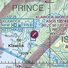
| FAA Identifier: | AKW |
| Lat/Long: | 55-34-45.2000N 133-04-33.6000W
55-34.753333N 133-04.560000W
55.5792222,-133.0760000
(estimated) |
| Elevation: | 79.7 ft. / 24.3 m (surveyed) |
| Variation: | 20E (2015) |
| From city: | 2 miles NE of KLAWOCK, AK |
| Time zone: | UTC -8 (UTC -9 during Standard Time) |
| Zip code: | 99925 |
Airport Operations
| Airport use: | Open to the public |
| Activation date: | 05/1975 |
| Control tower: | no |
| ARTCC: | ANCHORAGE CENTER |
| FSS: | KETCHIKAN FLIGHT SERVICE STATION [907-225-9481] |
| Alternate FSS: | JNU JUNEAU FLIGHT SERVICE STATION [1-866-297-2236] |
| NOTAMs facility: | AKW (NOTAM-D service available) |
| Attendance: | UNATNDD |
| Wind indicator: | lighted |
| Segmented circle: | yes |
| Lights: | ACTVT PAPI RWY 02 & 20; MIRL RWY 02/20; WINDSOCK; APRON LGTS - 122.25. |
| Beacon: | white-green (lighted land airport)
ACTVT ROTG BCN - CTAF. |
Airport Communications
| CTAF: | 120.9 |
| WX ASOS: | 135.45 (907-755-2641) |
- APCH/DEP SVC PRVDD BY ANCHORAGE ARTCC ON FREQS 118.5/284.6 (ANNETTE ISLAND RCAG).
- COMMUNICATIONS PRVDD BY KETCHIKAN FSS ON FREQS 122.25 (KLAWOCK RCO).
Airport Services
Runway Information
Runway 2/20
| Dimensions: | 5000 x 100 ft. / 1524 x 30 m |
| Surface: | asphalt/grooved, in good condition |
| Weight bearing capacity: | |
| Runway edge lights: | medium intensity |
| Operational restrictions: | SLOPES DOWN 55-65 FT FM THRS TO CNTR. EXP DOWNDRAFT & TURB INVOF RWY 02 TDZ. |
| RUNWAY 2 | | RUNWAY 20 |
| Latitude: | 55-34.435537N | | 55-35.072610N |
| Longitude: | 133-05.017330W | | 133-04.102370W |
| Elevation: | 38.7 ft. | | 79.7 ft. |
| Traffic pattern: | left | | right |
| Runway heading: | 019 magnetic, 039 true | | 199 magnetic, 219 true |
| Markings: | nonprecision, in fair condition | | nonprecision, in fair condition |
| Visual slope indicator: | 4-light PAPI on left (3.00 degrees glide path) | | 4-light PAPI on left (4.00 degrees glide path)
RWY 20 PAPI UNUSBL BYD 3 DEGS LEFT OF CNTRLN. |
| Runway end identifier lights: | yes | | yes |
| Touchdown point: | yes, no lights | | yes, no lights |
| Obstructions: | 15 ft. road, 201 ft. from runway, 60 ft. left and right of centerline
APCH SLOPE 0:1. ROAD BOTH SIDES OF RWY 0-200 FT FM THR. | | 15 ft. road, 201 ft. from runway, 60 ft. left of centerline
APCH SLOPE 0:1. ROAD ON L SIDE OF RWY 0-200 FT FM THR. |
Airport Ownership and Management from official FAA records
| Ownership: | Publicly-owned |
| Owner: | ALASKA DOT&PF SOUTHCOAST REGION
P.O. BOX 112506
JUNEAU, AK 99811-2506
Phone (907) 755-2229 |
| Manager: | JOSEPH JOHNSON
PO BOX 91, ALASKA DOT&PF
CRAIG, AK 99921-0091
Phone 907-755-2622 |
Additional Remarks
| A30A-20 | 700 FT HILL 2 MI NE OF THR. |
| - | BIRDS & WILDLIFE ON & INVOF ARPT. RPT BIRD ACT TO AMGR OR FSS. |
| - | RCMD DALGT OPS ONLY. |
| - | IREG WIND CONDS. |
| - | CLSD TO ACFT OVR 12500 LBS GTW EXC PPR - AMGR. |
| - | WX CAMERAS AVBL ON INTERNET AT HTTPS://WEATHERCAMS.FAA.GOV |
| - | COLD TEMPERATURE AIRPORT. ALTITUDE CORRECTION REQUIRED AT OR BELOW -10C. |
| - | HIGH TRRN ALL QUADS. |
| - | COND UNMNT; MAINT IREG; RCMD VISUAL INSP BFR USE. |
| - | PAJA ON RWY, TWY & PRKG APRON NA. |
| - | CLSD TO ACR OPS MORE THAN 30 PAX SEATS. |
Instrument Procedures
NOTE: All procedures below are presented as PDF files. If you need a reader for these files, you should download the free Adobe Reader.NOT FOR NAVIGATION. Please procure official charts for flight.
FAA instrument procedures published for use from 09 July 2026 at 0901Z to 06 August 2026 at 0900Z.
IAPs - Instrument Approach Procedures |
|---|
| RNAV (GPS) RWY 20 | |
download (369KB) |
| RNAV (GPS) Y RWY 02 | |
download (345KB) |
| NOTE: Special Alternate Minimums apply | |
download (172KB) |
Departure Procedures |
|---|
| TURTY FOUR (RNAV) | |
download (130KB) |
|
|---|
| KLAWOCK ONE (OBSTACLE) (RNAV) | |
download (215KB) |
| NOTE: Special Take-Off Minimums/Departure Procedures apply | |
download (453KB) |
Other nearby airports with instrument procedures:
PAKT - Ketchikan International Airport (48 nm E)
PAWG - Wrangell Airport (59 nm NE)
PAPG - Petersburg James A Johnson Airport (73 nm N)
PAFE - Kake Airport (87 nm N)
|
|

Road maps at:
MapQuest
Bing
Google
| Aerial photo |
|---|
WARNING: Photo may not be current or correct
 Photo by "Blade Runner"
Do you have a better or more recent aerial photo of Klawock Airport that you would like to share? If so, please send us your photo.
|
| Sectional chart |
|---|
|
| Airport distance calculator |
|---|
|
|
| Sunrise and sunset |
|---|
|
Times for 29-Jul-2026
| | Local
(UTC-8) | | Zulu
(UTC) |
|---|
| Morning civil twilight | | 04:06 | | 12:06 |
| Sunrise | | 04:54 | | 12:54 |
| Sunset | | 21:03 | | 05:03 |
| Evening civil twilight | | 21:52 | | 05:52 |
|
| Current date and time |
|---|
| Zulu (UTC) | 30-Jul-2026 05:23:24 |
|---|
| Local (UTC-8) | 29-Jul-2026 21:23:24 |
|---|
|
| METAR |
|---|
| PAKW | 300453Z AUTO 04003KT 10SM FEW048 SCT055 OVC110 15/11 A2993 RMK AO2 SLP134 T01500106 TSNO $
|
|
| TAF |
|---|
| PAKW | 291727Z 2918/3018 VRB02KT P6SM SCT015 OVC035 FM300700 05004KT P6SM BKN035 OVC050
|
|
| NOTAMs |
|---|
NOTAMs are issued by the DoD/FAA and will open in a separate window not controlled by AirNav.
|
|

