FAA INFORMATION EFFECTIVE 14 MAY 2026
Location
| FAA Identifier: | ANI |
| Lat/Long: | 61-34-53.0590N 159-32-43.0730W
61-34.884317N 159-32.717883W
61.5814053,-159.5452981
(estimated) |
| Elevation: | 96.8 ft. / 29.5 m (surveyed) |
| Variation: | 12E (2020) |
| Time zone: | UTC -8 (UTC -9 during Standard Time) |
| Zip code: | 99557 |
Airport Operations
| Airport use: | Open to the public |
| Activation date: | 08/1947 |
| Control tower: | no |
| ARTCC: | ANCHORAGE CENTER |
| FSS: | KENAI FLIGHT SERVICE STATION [907-283-7211] |
| NOTAMs facility: | ANI (NOTAM-D service available) |
| Attendance: | 1 MAY- 14 OCT MON- FRI 0730L-1630L, 15 OCT- 30 APR SUN-SAT 0730L-1630L |
| Wind indicator: | lighted |
| Segmented circle: | yes |
| Lights: | ACTVT MALSF RWY 11; PAPI RWY 11 & 29; HIRL RWY 11/29 - CTAF. |
| Beacon: | white-green (lighted land airport)
Operates sunset to sunrise. |
Airport Communications
| CTAF: | 122.1 |
| WX AWOS-3P: | 124.3 (907-621-7611) |
- APCH/DEP SVC PRVDD BY ANCHORAGE ARTCC ON FREQS 118.15/251.05 (ANIAK RCAG).
- CLEARANCE DELIVERY PRVDD BY ANCHORAGE ARTCC ON FREQ 118.15(ANIAK RCAG).
Nearby radio navigation aids
| NDB name | | Hdg/Dist | | Freq | | Var | | ID |
|---|
| ANIAK | | 095/1.6 | | 359 | | 14E | | ANI | .- -. .. |
Airport Services
| Fuel available: | 100LL JET-A
100LL:FUEL AVBL - CTAF OR 907-675-4295. |
| Parking: | tiedowns |
| Airframe service: | MINOR |
| Powerplant service: | MINOR |
Runway Information
Runway 11/29
| Dimensions: | 6200 x 100 ft. / 1890 x 30 m |
| Surface: | asphalt/grooved, in good condition |
| Weight bearing capacity: | | Single wheel: | 30.0 | | Double wheel: | 120.0 | | Double tandem: | 126.0 |
|
| Runway edge lights: | high intensity |
| RUNWAY 11 | | RUNWAY 29 |
| Latitude: | 61-35.147712N | | 61-34.620827N |
| Longitude: | 159-33.631108W | | 159-31.804927W |
| Elevation: | 96.8 ft. | | 96.7 ft. |
| Traffic pattern: | left | | left |
| Runway heading: | 109 magnetic, 121 true | | 289 magnetic, 301 true |
| Displaced threshold: | 400 ft. | | 400 ft. |
| Declared distances: | TORA:5800 TODA:6200 ASDA:5800 LDA:5400 | | TORA:5800 TODA:6200 ASDA:5800 LDA:5400 |
| Markings: | precision, in good condition | | nonprecision, in good condition |
| Visual slope indicator: | 4-light PAPI on right (3.00 degrees glide path) | | 4-light PAPI on right (3.00 degrees glide path) |
| Approach lights: | MALSF: 1,400 foot medium intensity approach lighting system with sequenced flashers | | |
| Touchdown point: | yes, no lights | | yes, no lights |
| Instrument approach: | ILS/DME | | |
| Obstructions: | 7 ft. road, 364 ft. from runway, 525 ft. left of centerline, 23:1 slope to clear | | 30 ft. pole, 310 ft. from runway, 513 ft. right of centerline, 3:1 slope to clear |
Airport Ownership and Management from official FAA records
| Ownership: | Publicly-owned |
| Owner: | ALASKA DOT&PF CENTRAL REGION
PO BOX 196900
ANCHORAGE, AK 99519-6900
Phone 907-269-0749 |
| Manager: | KEN SMITH
PO BOX 196900, ANIAK AIRPORT
ANCHORAGE, AK 99519
Phone 907-676-0505 |
Additional Remarks
| A39-11/29 | PCR VALUE: 405/F/A/X/T |
| - | LOCK WHEEL TURNS NA ALL SFCS. |
| - | FUEL TRUCK ACES AVBL SLOUGH BEACH E OF RAMP. |
| - | ARPT SAND LRGR GRADATION THAN FAA RCMDD/SEE AC150/5200-30. |
| - | PAEW ON THE RWY. |
| - | TSNT PRKG AVBL, MRKD WITH GREEN CONES. |
| - | WX CAMERA AVBL ON INTERNET AT HTTPS://WEATHERCAMS.FAA.GOV/. |
| - | COLD TEMPERATURE AIRPORT. ALTITUDE CORRECTION REQUIRED AT OR BELOW -37C. |
Instrument Procedures
NOTE: All procedures below are presented as PDF files. If you need a reader for these files, you should download the free Adobe Reader.NOT FOR NAVIGATION. Please procure official charts for flight.
FAA instrument procedures published for use from 14 May 2026 at 0901Z to 11 June 2026 at 0900Z.
IAPs - Instrument Approach Procedures |
|---|
| ILS OR LOC RWY 11 | |
download (234KB) |
| RNAV (GPS) RWY 11 | |
download (234KB) |
| RNAV (GPS) RWY 29 | |
download (229KB) |
| NOTE: Special Alternate Minimums apply | |
download (153KB) |
| NOTE: Special Take-Off Minimums/Departure Procedures apply | |
download (344KB) |
Other nearby airports with instrument procedures:
PACH - Chuathbaluk Airport (9 nm E)
PALG - Kalskag Airport (23 nm W)
PAHC - Holy Cross Airport (37 nm N)
PACJ - Crooked Creek Airport (44 nm NE)
PARS - Russian Mission Airport (52 nm W)
|
|

Road maps at:
MapQuest
Bing
Google
| Aerial photo |
|---|
WARNING: Photo may not be current or correct
 Photo by P. J. Reinders
Photo taken 11-May-2007
on final for runway 28
Photo by P. J. Reinders
Photo taken 11-May-2007
on final for runway 28
Do you have a better or more recent aerial photo of Aniak Airport that you would like to share? If so, please send us your photo.
|
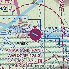
| Sectional chart |
|---|
|
| Airport distance calculator |
|---|
|
|
| Sunrise and sunset |
|---|
|
Times for 09-Jun-2026
| | Local
(UTC-8) | | Zulu
(UTC) |
|---|
| Morning civil twilight | | + | | + |
| Sunrise | | 05:00 | | 13:00 |
| Sunset | | 00:15 | | 08:15 |
| Evening civil twilight | | + | | + |
|
| Current date and time |
|---|
| Zulu (UTC) | 09-Jun-2026 16:36:55 |
|---|
| Local (UTC-8) | 09-Jun-2026 08:36:55 |
|---|
|
| METAR |
|---|
| PANI | 091556Z AUTO 00000KT 10SM CLR 06/M01 A2990 RMK AO2 SLP127 T00561006 $
|
|
| NOTAMs |
|---|
NOTAMs are issued by the DoD/FAA and will open in a separate window not controlled by AirNav.
|
|

