FAA INFORMATION EFFECTIVE 27 NOVEMBER 2025
Location
| FAA Identifier: | KSM |
| Lat/Long: | 62-03-38.9910N 163-18-06.6110W
62-03.649850N 163-18.110183W
62.0608308,-163.3018364
(estimated) |
| Elevation: | 314.1 ft. / 95.7 m (surveyed) |
| Variation: | 12E (2015) |
| From city: | 4 miles W of ST MARY'S, AK |
| Time zone: | UTC -9 (UTC -8 during Daylight Saving Time) |
Airport Operations
| Airport use: | Open to the public |
| Control tower: | no |
| ARTCC: | ANCHORAGE CENTER |
| FSS: | KENAI FLIGHT SERVICE STATION [907-283-7211] |
| NOTAMs facility: | KSM (NOTAM-D service available) |
| Attendance: | WINTER 0700-1530, SUMMER MON-FRI 0700-1530 |
| Wind indicator: | yes |
| Segmented circle: | yes |
| Lights: | ACTVT REIL RWY 17 & 35; PAPI RWY 17 & 35; HIRL RWY 17/35; MIRL RWY 06/24 - CTAF. |
| Beacon: | white-green (lighted land airport)
Operates sunset to sunrise. |
Airport Communications
| CTAF: | 122.3 |
| WX AWOS-3P: | 128.7 (907-438-2135) |
| WX AWOS-3P at MOU (11 nm W): | 118.35 (907-560-7618) |
- APCH/DEP SVC PRVDD BY ANCHORAGE ARTCC ON FREQ 124.0 (SAINT MARYS RCAG).
Nearby radio navigation aids
| NDB name | | Hdg/Dist | | Freq | | Var | | ID |
|---|
| ST MARYS | | at field | | 230 | | 12E | | SMA | ... -- .- |
Airport Services
Runway Information
Runway 17/35
| Dimensions: | 6008 x 150 ft. / 1831 x 46 m |
| Surface: | gravel, in good condition |
| Runway edge lights: | high intensity |
| RUNWAY 17 | | RUNWAY 35 |
| Latitude: | 62-04.251097N | | 62-03.266050N |
| Longitude: | 163-17.993583W | | 163-18.083022W |
| Elevation: | 290.3 ft. | | 311.3 ft. |
| Traffic pattern: | left | | left |
| Runway heading: | 170 magnetic, 182 true | | 350 magnetic, 002 true |
| Markings: | none, in fair condition | | none, in fair condition |
| Visual slope indicator: | 4-light PAPI on left (3.00 degrees glide path) | | 4-light PAPI on left (3.00 degrees glide path) |
| Runway end identifier lights: | yes | | yes |
| Touchdown point: | yes, no lights | | yes, no lights |
| Instrument approach: | LOC/DME | | |
Runway 6/24
| Dimensions: | 1520 x 60 ft. / 463 x 18 m |
| Surface: | gravel, in good condition |
| Runway edge lights: | medium intensity |
| RUNWAY 6 | | RUNWAY 24 |
| Latitude: | 62-03.192802N | | 62-03.247325N |
| Longitude: | 163-18.653513W | | 163-18.134967W |
| Elevation: | 314.1 ft. | | 308.7 ft. |
| Traffic pattern: | left | | left |
| Runway heading: | 065 magnetic, 077 true | | 245 magnetic, 257 true |
| Markings: | none, in good condition | | none, in good condition |
| Touchdown point: | yes, no lights | | yes, no lights |
| Obstructions: | 145 ft. hill, 3480 ft. from runway, 24:1 slope to clear | | 100 ft. hill, 5000 ft. from runway |
Airport Ownership and Management from official FAA records
| Ownership: | Publicly-owned |
| Owner: | ALASKA DOT&PF NORTHERN REGION
2301 PEGER ROAD
FAIRBANKS, AK 99709
Phone 907-443-3411 |
| Manager: | ERIK WEINGARTH
PO BOX 135
ST MARY'S, AK 99658
Phone 907-438-2416 |
Additional Remarks
| - | SNOW & ICE REMOVAL & HAZ RPRTG DURG DURING DUTY HR; AFT HR PPR IN WRITING - AMGR. |
| - | WX CAMERA AVBL ON INTERNET AT HTTPS://WEATHERCAMS.FAA.GOV |
| - | PSBL RWY DRIFTING SNOW & POOR BRAKING; COND RPRT DALGT OPS ONLY. |
| - | CLSD TO OPS RQRG PAX SCREENING. |
Instrument Procedures
NOTE: All procedures below are presented as PDF files. If you need a reader for these files, you should download the free Adobe Reader.NOT FOR NAVIGATION. Please procure official charts for flight.
FAA instrument procedures published for use from 27 November 2025 at 0901Z to 25 December 2025 at 0900Z.
IAPs - Instrument Approach Procedures |
|---|
| RNAV (GPS) RWY 17 | |
download (242KB) |
| RNAV (GPS) RWY 35 | |
download (289KB) |
| LOC RWY 17 | |
download (281KB) |
| NOTE: Special Alternate Minimums apply | |
download (156KB) |
| NOTE: Special Take-Off Minimums/Departure Procedures apply | |
download (398KB) |
Other nearby airports with instrument procedures:
PAMO - Mountain Village Airport (11 nm W)
PADM - Marshall Don Hunter Sr Airport (38 nm E)
PAEM - Emmonak Airport (55 nm NW)
PFKO - Kotlik Airport (59 nm N)
PARS - Russian Mission Airport (59 nm E)
|
|

Road maps at:
MapQuest
Bing
Google
| Aerial photo |
|---|
WARNING: Photo may not be current or correct
 Photo by Bob McCormick
Photo taken 15-Apr-2010
Photo by Bob McCormick
Photo taken 15-Apr-2010
Do you have a better or more recent aerial photo of St Mary's Airport that you would like to share? If so, please send us your photo.
|
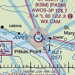
| Sectional chart |
|---|
|
| Airport distance calculator |
|---|
|
|
| Sunrise and sunset |
|---|
|
Times for 01-Dec-2025
| | Local
(UTC-9) | | Zulu
(UTC) |
|---|
| Morning civil twilight | | 09:48 | | 18:48 |
| Sunrise | | 10:49 | | 19:49 |
| Sunset | | 16:36 | | 01:36 |
| Evening civil twilight | | 17:37 | | 02:37 |
|
| Current date and time |
|---|
| Zulu (UTC) | 01-Dec-2025 18:21:19 |
|---|
| Local (UTC-9) | 01-Dec-2025 09:21:19 |
|---|
|
| METAR |
|---|
| PASM | 011756Z AUTO 02016KT 2 1/2SM -SN BR BKN018 OVC024 M05/M06 A2969 RMK AO2 SLP063 P0000 60000 T10501056 11044 21050 51018 FZRANO
|
PAMO
11nm W | 011756Z AUTO 01018G22KT 3SM -SN BR BKN008 BKN022 OVC033 M05/M06 A2969 RMK AO2 PK WND 02026/1715 SLP060 P0000 60000 T10501061 11050 21050 53025 FZRANO
|
|
| NOTAMs |
|---|
NOTAMs are issued by the DoD/FAA and will open in a separate window not controlled by AirNav.
|
|

