FAA INFORMATION EFFECTIVE 16 APRIL 2026
Location
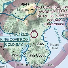
| FAA Identifier: | KVC |
| Lat/Long: | 55-06-58.9830N 162-15-59.5280W
55-06.983050N 162-15.992133W
55.1163842,-162.2665356
(estimated) |
| Elevation: | 148.9 ft. / 45.4 m (surveyed) |
| Variation: | 10E (2020) |
| From city: | 4 miles NE of KING COVE, AK |
| Time zone: | UTC -8 (UTC -9 during Standard Time) |
| Zip code: | 99612 |
Airport Operations
| Airport use: | Open to the public |
| Control tower: | no |
| ARTCC: | ANCHORAGE CENTER |
| FSS: | COLD BAY FLIGHT SERVICE STATION [907-532-2466] |
| Alternate FSS: | ENA KENAI FLIGHT SERVICE STATION [1-866-864-1737] |
| NOTAMs facility: | KVC (NOTAM-D service available) |
| Attendance: | UNATNDD |
| Wind indicator: | lighted |
| Segmented circle: | yes |
| Lights: | ACVT REIL RWY 08, 26; PAPI RWY 08, 26; MIRL RWY 08/26 - CTAF. |
| Beacon: | white-green (lighted land airport)
Operates sunset to sunrise. |
Airport Communications
| CTAF: | 122.9 |
| WX AWOS-3P: | 118.325 (907-497-4279) |
| WX ASOS at CDB (17 nm W): | 135.75 (907-532-2639) |
- APCH/DEP SVC PRVDD BY ANCHORAGE ARTCC ON FREQS 118.5/278.3 (COLD BAY RCAG).
Nearby radio navigation aids
| VOR radial/distance | | VOR name | | Freq | | Var |
|---|
| CDBr108/19.6 | | COLD BAY VORTAC | | 112.60 | | 10E |
| NDB name | | Hdg/Dist | | Freq | | Var | | ID |
|---|
| ELFEE | | 111/20.9 | | 341 | | 10E | | ELF | . .-.. ..-. |
Airport Services
| Airframe service: | NONE |
| Powerplant service: | NONE |
| Bottled oxygen: | NONE |
| Bulk oxygen: | NONE |
Runway Information
Runway 8/26
| Dimensions: | 3500 x 115 ft. / 1067 x 35 m |
| Surface: | gravel, in good condition
RWY SOFT DURING SPRING BREAKUP & AFTER HVY RAIN.
GRVL-DIRT |
| Runway edge lights: | medium intensity |
| RUNWAY 8 | | RUNWAY 26 |
| Latitude: | 55-06.973797N | | 55-06.992260N |
| Longitude: | 162-16.493463W | | 162-15.490812W |
| Elevation: | 146.0 ft. | | 144.1 ft. |
| Traffic pattern: | left | | left |
| Runway heading: | 078 magnetic, 088 true | | 258 magnetic, 268 true |
| Markings: | , in fair condition | | , in fair condition |
| Visual slope indicator: | 4-light PAPI on left (4.00 degrees glide path)
PAPI UNUSBL BYD 5 DEGS LEFT AND RIGHT CNTRLN. | | 4-light PAPI on left (3.00 degrees glide path) |
| Runway end identifier lights: | yes | | yes |
| Touchdown point: | yes, no lights | | yes, no lights |
| Obstructions: | 15 ft. road, 611 ft. from runway, 40:1 slope to clear | | 15 ft. hill, 600 ft. from runway, 336 ft. right of centerline, 40:1 slope to clear |
Airport Ownership and Management from official FAA records
| Ownership: | Publicly-owned |
| Owner: | ALASKA DOT&PF SOUTHCOAST REGION
1500 ANTON LARSON ROAD
KODIAK, AK 99615-6900
Phone (907) 487-4952 |
| Manager: | HAROLD "HAP" KREMER
BOX 97
COLD BAY, AK 99571
Phone 907-532-5000 |
Additional Remarks
| - | 16+ KTS WINDS IN NE E NW QUADTS. WIND FUNNELS DOWN CANYON WEST OF RWY 08. |
| - | COLD TEMPERATURE AIRPORT. ALTITUDE CORRECTION REQUIRED AT OR BELOW -8C. |
| - | RWY COND NOT MONITORED; RCMD VISUAL INSPECTION PRIOR TO USING. |
| - | WX CAMERA AVBL ON INTERNET AT HTTPS://WEATHERCAMS.FAA.GOV. |
| - | FBO SERVICE PHONE: 907-497-2683 |
Instrument Procedures
NOTE: All procedures below are presented as PDF files. If you need a reader for these files, you should download the free Adobe Reader.NOT FOR NAVIGATION. Please procure official charts for flight.
FAA instrument procedures published for use from 16 April 2026 at 0901Z to 14 May 2026 at 0900Z.
IAPs - Instrument Approach Procedures |
|---|
| RNAV (GPS)-A | |
download (277KB) |
| NOTE: Special Alternate Minimums apply | |
download (147KB) |
|
|---|
| COLD BAY TWO (OBSTACLE) (RNAV) | |
download (204KB) |
| NOTE: Special Take-Off Minimums/Departure Procedures apply | |
download (405KB) |
Other nearby airports with instrument procedures:
PACD - Cold Bay Airport (17 nm W)
PASD - Sand Point Airport (61 nm E)
PAOU - Nelson Lagoon Airport (65 nm NE)
|
|

Road maps at:
MapQuest
Bing
Google
| Aerial photo |
|---|
WARNING: Photo may not be current or correct

Do you have a better or more recent aerial photo of King Cove Airport that you would like to share? If so, please send us your photo.
|
| Sectional chart |
|---|
|
| Airport distance calculator |
|---|
|
|
| Sunrise and sunset |
|---|
|
Times for 10-May-2026
| | Local
(UTC-8) | | Zulu
(UTC) |
|---|
| Morning civil twilight | | 06:04 | | 14:04 |
| Sunrise | | 06:50 | | 14:50 |
| Sunset | | 22:41 | | 06:41 |
| Evening civil twilight | | 23:27 | | 07:27 |
|
| Current date and time |
|---|
| Zulu (UTC) | 10-May-2026 19:04:41 |
|---|
| Local (UTC-8) | 10-May-2026 11:04:41 |
|---|
|
| METAR |
|---|
| PAVC | 101856Z AUTO 30008KT 9SM -SN OVC021 M01/M05 A2966 RMK AO2 SNB11 SLP047 P0000 T10061050 FZRANO $
|
PACD
16nm W | 101853Z 31010KT 10SM SCT025 OVC033 01/M06 A2964 RMK AO2 SLP039 T00061056
|
|
| TAF |
|---|
PACD
16nm W | 101802Z 1018/1118 29011KT P6SM OVC025 FM110100 15015KT P6SM OVC025 FM110900 15015G30KT P6SM -SHRA OVC025
|
|
| NOTAMs |
|---|
NOTAMs are issued by the DoD/FAA and will open in a separate window not controlled by AirNav.
|
|

