FAA INFORMATION EFFECTIVE 14 MAY 2026
Location
| FAA Identifier: | LNY |
| Lat/Long: | 20-47-08.2000N 156-57-05.1050W
20-47.136667N 156-57.085083W
20.7856111,-156.9514181
(estimated) |
| Elevation: | 1308.1 ft. / 398.7 m (surveyed) |
| Variation: | 11E (1990) |
| From city: | 3 miles SW of LANAI CITY, HI |
| Time zone: | UTC -10 (year round; does not observe DST) |
| Zip code: | 96763 |
Airport Operations
| Airport use: | Open to the public |
| Activation date: | 09/1946 |
| Control tower: | no |
| ARTCC: | HONOLULU CONTROL FACILITY CENTER |
| FSS: | HONOLULU FLIGHT SERVICE STATION |
| NOTAMs facility: | LNY (NOTAM-D service available) |
| Attendance: | 0600-1800 |
| Pattern altitude: | TPA SMALL ACFT 2100' MSL. LARGE ACFT 2800' MSL. |
| Wind indicator: | lighted |
| Segmented circle: | no |
| Lights: | ACTVT PAPI RWY 3 & 21; MIRL RWY 03/21 - CTAF. |
| Beacon: | white-green (lighted land airport)
DUSK-DAWN. |
| Fire and rescue: | ARFF index A |
| Airline operations: | ARPT CLOSED TO AIR CARRIER OPS WITH 10 OR MORE PASSENGER SEATS 1930-0600 EXCEPT PPR, CALL 808-565-7942. |
Airport Communications
| CTAF: | 122.9 |
| WX AWOS-3P: | 118.375 (808-565-6586) |
| WX AWOS-3PT at JHM (19 nm NE): | 118.525 (808-665-6101) |
- APCH/DEP SVC PRVDD BY HONOLULU CONTROL FACILITY (ZHN) ON FREQ 119.3 & 307.1 (MOUNT HALEAKALA RCAG).
Nearby radio navigation aids
| VOR radial/distance | | VOR name | | Freq | | Var |
|---|
| LNYr027/1.6 | | LANAI VORTAC | | 117.70 | | 11E |
| MKKr139/24.4 | | MOLOKAI VORTAC | | 116.10 | | 11E |
| OGGr245/30.6 | | MAUI VORTAC | | 115.10 | | 11E |
Airport Services
| Fuel available: | A
A:JET A FUEL 5000 GAL. POC: MIKE HANOC 808-286-7075 |
| Parking: | tiedowns |
| Airframe service: | NONE |
| Powerplant service: | NONE |
| Bottled oxygen: | NONE |
| Bulk oxygen: | NONE |
Runway Information
Runway 3/21
| Dimensions: | 5001 x 150 ft. / 1524 x 46 m |
| Surface: | asphalt/grooved, in good condition |
| Weight bearing capacity: | | Single wheel: | 75.0 | | Double wheel: | 110.0 | | Double tandem: | 170.0 |
|
| Runway edge lights: | medium intensity |
| RUNWAY 3 | | RUNWAY 21 |
| Latitude: | 20-46.839800N | | 20-47.433517N |
| Longitude: | 156-57.390350W | | 156-56.779783W |
| Elevation: | 1306.6 ft. | | 1308.1 ft. |
| Traffic pattern: | left | | left |
| Runway heading: | 033 magnetic, 044 true | | 213 magnetic, 224 true |
| Declared distances: | TORA:5000 TODA:5000 ASDA:5000 LDA:5000 | | TORA:5000 TODA:5000 ASDA:5000 LDA:5000 |
| Markings: | precision, in good condition | | nonprecision, in good condition |
| Visual slope indicator: | 4-light PAPI on right (3.00 degrees glide path) | | 4-light PAPI on left (3.76 degrees glide path)
PAPI UNUSBL BYD 2 NM DUE TO TRRN. |
| Runway end identifier lights: | | | no |
| Touchdown point: | yes, no lights | | yes, no lights |
| Instrument approach: | ILS/DME | | |
| Obstructions: | none | | 20 ft. ant, 1000 ft. from runway, 250 ft. right of centerline, 40:1 slope to clear |
Airport Ownership and Management from official FAA records
| Ownership: | Publicly-owned |
| Owner: | HAWAII ST ARPTS DIV
HONOLULU INTL ARPT
HONOLULU, HI 96819
Phone 808-838-8600 |
| Manager: | MARVIN MONIZ
KAHULUI ARPT
KAHULUI, HI 96732
Phone 808-281-8801
ARPT OPNS/MAINT MAN/AOM/MR. ALAN FERNANDEZ PHONE 565-7942, CELL PHONE 281-9899. |
Additional Remarks
| A39-03/21 | PCR VALUE: 317/F/B/X/T |
| - | SEE AREA NOTICES, TFC ADVYS AT NON-TWR ARPTS. |
| - | FIXED WING TSNT PRKG NE SIDE OF RAMP IS ASPH. |
| - | FOR CD IF UNA TO CTC ON FSS FREQ, CTC HONOLULU CONTROL FACILITY AT 808-840-6262. |
| - | 24 HRS PPR FOR DIVISION 1.1,1.2,1.3 EXPLOSIVES AND 4 HRS PPR FOR HAZARDOUS MATERIAL IN/OUT OF ARPT CTC 808-565-7941/7943. |
| - | DUE TO RAMP LIMITATIONS ALL ACFT PARKING LIMITED TO ONE HR EXCP VIA PPR CALL 808-565-7942; FAX 808-565-7940 OR 808-872-3880. |
| - | JET PRKG SW SIDE OF RAMP IS CONC. |
| - | POSSIBLE SEVERE UPDRAFTS/DOWNDRAFTS FROM 2 MILE FINAL APPROACH TO RUNWAY 3 THRESHHOLD. |
Instrument Procedures
NOTE: All procedures below are presented as PDF files. If you need a reader for these files, you should download the free Adobe Reader.NOT FOR NAVIGATION. Please procure official charts for flight.
FAA instrument procedures published for use from 14 May 2026 at 0901Z to 11 June 2026 at 0900Z.
IAPs - Instrument Approach Procedures |
|---|
| ILS OR LOC RWY 03 | |
download (271KB) |
| RNAV (GPS) RWY 03 | |
download (200KB) |
| VOR OR TACAN OR GPS-A | |
download (183KB) |
| VOR OR TACAN RWY 03 | |
download (219KB) |
| NOTE: Special Alternate Minimums apply | |
download (118KB) |
| NOTE: Special Take-Off Minimums/Departure Procedures apply | |
download (50KB) |
Other nearby airports with instrument procedures:
PHMK - Molokai Airport (23 nm N)
PHLU - Kalaupapa Airport (26 nm N)
PHOG - Kahului Airport (30 nm E)
PHHN - Hana Airport (53 nm E)
PHNG - Kaneohe Bay Marine Corps Air Station (Marion E Carl Field) (61 nm NW)
|
|

Road maps at:
MapQuest
Bing
Google
| Aerial photo |
|---|
WARNING: Photo may not be current or correct
 Photo by Charles K. Morris, South Ramp Solutions LLC
Photo taken 30-Apr-2007
from a Cirrus SR20
Photo by Charles K. Morris, South Ramp Solutions LLC
Photo taken 30-Apr-2007
from a Cirrus SR20
Do you have a better or more recent aerial photo of Lanai Airport that you would like to share? If so, please send us your photo.
|
| Sectional chart |
|---|
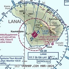
|
CAUTION: Diagram may not be current

| Airport distance calculator |
|---|
|
|
| Sunrise and sunset |
|---|
|
Times for 30-May-2026
| | Local
(UTC-10) | | Zulu
(UTC) |
|---|
| Morning civil twilight | | 05:23 | | 15:23 |
| Sunrise | | 05:47 | | 15:47 |
| Sunset | | 19:03 | | 05:03 |
| Evening civil twilight | | 19:28 | | 05:28 |
|
| Current date and time |
|---|
| Zulu (UTC) | 30-May-2026 22:33:53 |
|---|
| Local (UTC-10) | 30-May-2026 12:33:53 |
|---|
|
| METAR |
|---|
PHNY
2nm SE | 302203Z AUTO 23008KT 10SM BKN026 BKN033 26/18 A3007 RMK AO2 $
|
|
| TAF |
|---|
PHNY
2nm SE | 301737Z 3018/3118 06004KT P6SM FEW025 FM302100 23010KT P6SM BKN025 FM310500 04007KT P6SM FEW025
|
|
| NOTAMs |
|---|
NOTAMs are issued by the DoD/FAA and will open in a separate window not controlled by AirNav.
|
|


