FAA INFORMATION EFFECTIVE 19 FEBRUARY 2026
Location
| FAA Identifier: | PSK |
| Lat/Long: | 37-08-14.4110N 080-40-42.5260W
37-08.240183N 080-40.708767W
37.1373364,-80.6784794
(estimated) |
| Elevation: | 2104.5 ft. / 641.5 m (surveyed) |
| Variation: | 06W (1985) |
| From city: | 2 miles N of DUBLIN, VA |
| Time zone: | UTC -5 (UTC -4 during Daylight Saving Time) |
| Zip code: | 24084 |
Airport Operations
| Airport use: | Open to the public |
| Activation date: | 07/1961 |
| Control tower: | no |
| ARTCC: | WASHINGTON CENTER |
| FSS: | LEESBURG FLIGHT SERVICE STATION |
| NOTAMs facility: | PSK (NOTAM-D service available) |
| Attendance: | MON-FRI 0800-1900, ALL SAT-SUN 0900-1700
UNATTENDED THANKSGIVING AND CHRISTMAS DAY. |
| Wind indicator: | lighted |
| Segmented circle: | yes |
| Lights: | ACTVT MALSR RWY 06; REIL RWY 24; PAPI RWY 06 & 24; HIRL RWY 06/24 - CTAF. |
| Beacon: | white-green (lighted land airport)
Operates sunset to sunrise. |
Airport Communications
| CTAF/UNICOM: | 122.7 |
| WX AWOS-3: | 127.375 (540-674-2731) |
| ROANOKE APPROACH: | 126.0 |
| ROANOKE DEPARTURE: | 126.0 |
| CLEARANCE DELIVERY: | 121.7 |
| IC: | 126.0 |
| WX AWOS-3 at BCB (13 nm E): | 133.325 (540-231-4837) |
Nearby radio navigation aids
| VOR radial/distance | | VOR name | | Freq | | Var |
|---|
| PSKr035/3.4 | | PULASKI VORTAC | | 116.80 | | 06W |
| BLFr115/26.7 | | BLUEFIELD VOR/DME | | 115.05 | | 03W |
| NDB name | | Hdg/Dist | | Freq | | Var | | ID |
|---|
| TECH | | 260/13.8 | | 368 | | 08W | | TEC | - . -.-. |
| VINTON | | 272/38.3 | | 277 | | 08W | | VIT | ...- .. - |
Airport Services
| Fuel available: | 100LL JET-A+ |
| Parking: | hangars and tiedowns |
| Airframe service: | MAJOR |
| Powerplant service: | MAJOR |
| Bulk oxygen: | NONE |
Runway Information
Runway 6/24
| Dimensions: | 6201 x 150 ft. / 1890 x 46 m |
| Surface: | asphalt/grooved, in good condition |
| Weight bearing capacity: | |
| Runway edge lights: | high intensity |
| RUNWAY 6 | | RUNWAY 24 |
| Latitude: | 37-07.926307N | | 37-08.554022N |
| Longitude: | 080-41.212238W | | 080-40.205230W |
| Elevation: | 2104.5 ft. | | 2073.0 ft. |
| Traffic pattern: | left | | left |
| Runway heading: | 058 magnetic, 052 true | | 238 magnetic, 232 true |
| Markings: | precision, in fair condition | | nonprecision, in fair condition |
| Visual slope indicator: | 4-light PAPI on left (3.00 degrees glide path) | | 4-light PAPI on left (3.00 degrees glide path) |
| Approach lights: | MALSR: 1,400 foot medium intensity approach lighting system with runway alignment indicator lights | | |
| Runway end identifier lights: | | | yes |
| Touchdown point: | yes, no lights | | yes, no lights |
| Instrument approach: | ILS | | |
| Obstructions: | 97 ft. trees, 2139 ft. from runway, 617 ft. right of centerline, 19:1 slope to clear
10 FT ROAD 100 FT FM THR ON CNTRLN (SVC ROAD). | | 8 ft. tree, 308 ft. from runway, 23 ft. right of centerline, 13:1 slope to clear |
Airport Ownership and Management from official FAA records
| Ownership: | Publicly-owned |
| Owner: | NEW RIVER VALLEY ARPT CMSN
5391 C. V. JACKSON ROAD
DUBLIN, VA 24084
Phone 540-674-4141 |
| Manager: | AARON BRUMMITT
5391 C. V. JACKSON ROAD
DUBLIN, VA 24084
Phone 540-674-4141 |
Additional Remarks
| - | DEER ON & INVOF ARPT. |
| - | MIL CONTRACT FUEL UNAVBL. |
| - | ROA TWR SVCS AVBL AT 540-563-1307. |
Instrument Procedures
NOTE: All procedures below are presented as PDF files. If you need a reader for these files, you should download the free Adobe Reader.NOT FOR NAVIGATION. Please procure official charts for flight.
FAA instrument procedures published for use from 19 February 2026 at 0901Z to 19 March 2026 at 0900Z.
IAPs - Instrument Approach Procedures |
|---|
| ILS OR LOC Y RWY 06 | |
download (275KB) |
| ILS OR LOC Z RWY 06 | |
download (292KB) |
| RNAV (GPS) RWY 06 | |
download (298KB) |
| RNAV (GPS) RWY 24 | |
download (248KB) |
| NOTE: Special Alternate Minimums apply | |
download (169KB) |
| NOTE: Special Take-Off Minimums/Departure Procedures apply | |
download (140KB) |
Other nearby airports with instrument procedures:
KBCB - Virginia Tech/Montgomery Executive Airport (13 nm E)
KHLX - Twin County Airport (23 nm S)
KBLF - Mercer County Airport (27 nm W)
KMKJ - Mountain Empire Airport (35 nm SW)
KROA - Roanoke-Blacksburg Regional Airport/Woodrum Field (35 nm E)
|
|

Road maps at:
MapQuest
Bing
Google
| Aerial photo |
|---|
WARNING: Photo may not be current or correct
 Photo taken 22-Feb-2012
looking east.
Photo taken 22-Feb-2012
looking east.
Do you have a better or more recent aerial photo of New River Valley Airport that you would like to share? If so, please send us your photo.
|
| Sectional chart |
|---|
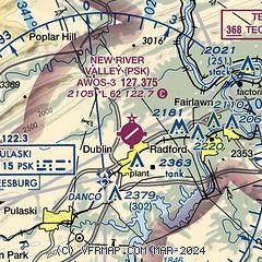
|
| Airport distance calculator |
|---|
|
|
| Sunrise and sunset |
|---|
|
Times for 18-Mar-2026
| | Local
(UTC-4) | | Zulu
(UTC) |
|---|
| Morning civil twilight | | 07:04 | | 11:04 |
| Sunrise | | 07:30 | | 11:30 |
| Sunset | | 19:31 | | 23:31 |
| Evening civil twilight | | 19:57 | | 23:57 |
|
| Current date and time |
|---|
| Zulu (UTC) | 18-Mar-2026 19:44:43 |
|---|
| Local (UTC-4) | 18-Mar-2026 15:44:43 |
|---|
|
| METAR |
|---|
| KPSK | 181935Z AUTO 00000KT 10SM BKN060 BKN075 05/M11 A3020 RMK AO2 T00531112
|
KBCB
13nm E | 181935Z AUTO 18005KT 10SM BKN070 OVC080 06/M08 A3024 RMK AO2 T00591080
|
|
| TAF |
|---|
KBCB
13nm E | 181720Z 1818/1918 00000KT P6SM BKN090 FM182300 00000KT P6SM BKN045 FM191500 27003KT P6SM BKN100
|
|
| NOTAMs |
|---|
NOTAMs are issued by the DoD/FAA and will open in a separate window not controlled by AirNav.
|
|

