FAA INFORMATION EFFECTIVE 17 APRIL 2025
Location
| FAA Identifier: | PTN |
| Lat/Long: | 29-42-34.3670N 091-20-20.3230W
29-42.572783N 091-20.338717W
29.7095464,-91.3389786
(estimated) |
| Elevation: | 8.5 ft. / 2.6 m (surveyed) |
| Variation: | 01E (2005) |
| From city: | 2 miles NW of PATTERSON, LA |
| Time zone: | UTC -5 (UTC -6 during Standard Time) |
| Zip code: | 70392 |
Airport Operations
| Airport use: | Open to the public |
| Activation date: | 04/1940 |
| Control tower: | no |
| ARTCC: | HOUSTON CENTER |
| FSS: | DE RIDDER FLIGHT SERVICE STATION |
| NOTAMs facility: | PTN (NOTAM-D service available) |
| Attendance: | CONTINUOUS |
| Wind indicator: | lighted |
| Segmented circle: | no |
| Lights: | ACTVT MALSR RWY 24; MIRL RWY 06/24 PRESET MED INTST, TO INCR INTST - CTAF. |
| Beacon: | white-green (lighted land airport)
Operates sunset to sunrise. |
| International operations: | customs landing rights airport |
Airport Communications
| CTAF/UNICOM: | 122.8 |
| WX AWOS-3PT: | 134.575 (985-395-6735) |
| NEW ORLEANS APPROACH: | 124.3 |
| NEW ORLEANS DEPARTURE: | 124.3 |
| CLEARANCE DELIVERY: | 124.3 |
Nearby radio navigation aids
| VOR radial/distance | | VOR name | | Freq | | Var |
|---|
| TBDr274/26.7 | | TIBBY VOR/DME | | 117.15 | | 02E |
Airport Services
| Fuel available: | 100LL JET-A |
| Parking: | hangars and tiedowns |
| Airframe service: | MAJOR |
| Powerplant service: | MAJOR |
| Bottled oxygen: | NONE |
| Bulk oxygen: | NONE |
Runway Information
Runway 6/24
| Dimensions: | 5399 x 150 ft. / 1646 x 46 m |
| Surface: | asphalt, in fair condition |
| Weight bearing capacity: | |
| Runway edge lights: | medium intensity |
| RUNWAY 6 | | RUNWAY 24 |
| Latitude: | 29-42.420437N | | 29-42.877778N |
| Longitude: | 091-20.820530W | | 091-19.944982W |
| Elevation: | 6.7 ft. | | 8.4 ft. |
| Traffic pattern: | left | | right |
| Runway heading: | 058 magnetic, 059 true | | 238 magnetic, 239 true |
| Displaced threshold: | 394 ft. | | no |
| Markings: | nonprecision, in fair condition | | precision, in fair condition |
| Visual slope indicator: | 2-light PAPI on left (3.00 degrees glide path) | | 2-light PAPI on left (3.00 degrees glide path) |
| Approach lights: | | | MALSR: 1,400 foot medium intensity approach lighting system with runway alignment indicator lights |
| Runway end identifier lights: | yes | | no |
| Touchdown point: | yes, no lights | | yes, no lights |
| Instrument approach: | | | ILS/DME |
| Obstructions: | 58 ft. trees, 1491 ft. from runway, 262 ft. left of centerline, 22:1 slope to clear
APCH RATIO 23:1 TO DTHR. | | none |
Runway 4W/22W
| Dimensions: | 4500 x 100 ft. / 1372 x 30 m |
| Surface: | water, in good condition |
| RUNWAY 4W | | RUNWAY 22W |
| Latitude: | 29-42.265167N | | 29-42.695667N |
| Longitude: | 091-20.631833W | | 091-19.939717W |
| Elevation: | 1.0 ft. | | 1.0 ft. |
| Traffic pattern: | right | | left |
| Runway heading: | 054 magnetic, 055 true | | 234 magnetic, 235 true |
| Touchdown point: | yes, no lights | | yes, no lights |
| Obstructions: | 20 ft. road, 600 ft. from runway, 30:1 slope to clear | | none |
Airport Ownership and Management from official FAA records
| Ownership: | Publicly-owned |
| Owner: | STATE OF LOUISIANA
DOTD AVIATION SECTION, PO BOX 94245
BATON ROUGE, LA 70804
Phone 225-379-3950 |
| Manager: | PAUL J. GOVERNAK
500 MAIN ST, 5TH FLOOR COURTHOUSE
FRANKLIN, LA 70538
Phone 337-828-4100 |
Additional Remarks
| - | 4500 FT BY 100 FT WATERWAY HDG 04/22 LCTD 1100 FT SOUTH OF CONC RWY. DUAL LAND/SEA OPERATION. |
| - | FOR CD CTC NEW ORLEANS APCH AT 504-471-4350 OR 124.3. |
| - | PILOTS CONDUCTING EFVS OPS; BE AWARE LED ALS IN USE RWY 24. |
| - | CTC ARPT MGR FOR DSNGD RAMP SPACE FOR PUB USE AT ARPT |
Instrument Procedures
NOTE: All procedures below are presented as PDF files. If you need a reader for these files, you should download the free Adobe Reader.NOT FOR NAVIGATION. Please procure official charts for flight.
FAA instrument procedures published for use from 17 April 2025 at 0901Z to 15 May 2025 at 0900z.
IAPs - Instrument Approach Procedures |
|---|
| ILS OR LOC RWY 24 | |
download (315KB) |
| RNAV (GPS) RWY 06 | |
download (268KB) |
| RNAV (GPS) RWY 24 | |
download (299KB) |
| NOTE: Special Alternate Minimums apply | |
download (160KB) |
| NOTE: Special Take-Off Minimums/Departure Procedures apply | |
download (303KB) |
Other nearby airports with instrument procedures:
L83 - Thibodaux Municipal Airport (26 nm E)
KARA - Acadiana Regional Airport (35 nm NW)
KREG - Louisiana Regional Airport (35 nm NE)
KHUM - Houma-Terrebonne Airport (36 nm E)
KIYA - Abbeville Chris Crusta Memorial Airport (42 nm NW)
|
|

Road maps at:
MapQuest
Bing
Google
| Aerial photo |
|---|
WARNING: Photo may not be current or correct
 Photo taken 26-Jul-2011
looking north.
Photo taken 26-Jul-2011
looking north.
Do you have a better or more recent aerial photo of Harry P Williams Memorial Airport that you would like to share? If so, please send us your photo.
|
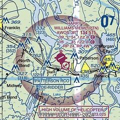
| Sectional chart |
|---|
|
| Airport distance calculator |
|---|
|
|
| Sunrise and sunset |
|---|
|
Times for 25-Apr-2025
| | Local
(UTC-5) | | Zulu
(UTC) |
|---|
| Morning civil twilight | | 06:05 | | 11:05 |
| Sunrise | | 06:29 | | 11:29 |
| Sunset | | 19:37 | | 00:37 |
| Evening civil twilight | | 20:02 | | 01:02 |
|
| Current date and time |
|---|
| Zulu (UTC) | 26-Apr-2025 03:22:43 |
|---|
| Local (UTC-5) | 25-Apr-2025 22:22:43 |
|---|
|
| METAR |
|---|
| KPTN | 260256Z AUTO 00000KT 10SM CLR 23/22 A3011 RMK AO2 SLP196 T02330217 53017 $
|
|
| TAF |
|---|
KARA
34nm NW | 260101Z 2601/2624 17006KT P6SM VCTS SCT040CB TEMPO 2601/2604 2SM TSRA BKN020CB FM260800 VRB03KT 3SM BR SCT040 TEMPO 2608/2611 1SM BR SCT035 FM261100 18004KT P6SM BKN250 FM261400 15005KT P6SM SCT250
|
KHUM
36nm E | 251728Z 2518/2618 17010KT P6SM SCT020 SCT120 FM260100 00000KT P6SM FEW025 SCT200 TEMPO 2611/2613 5SM BR BKN003 FM261400 12006KT P6SM FEW035 SCT250
|
|
| NOTAMs |
|---|
NOTAMs are issued by the DoD/FAA and will open in a separate window not controlled by AirNav.
|
|


