FAA INFORMATION EFFECTIVE 11 JUNE 2026
Location
| FAA Identifier: | RFD |
| Lat/Long: | 42-11-43.3000N 089-05-50.0000W
42-11.721667N 089-05.833333W
42.1953611,-89.0972222
(estimated) |
| Elevation: | 742 ft. / 226.2 m (surveyed) |
| Variation: | 03W (2020) |
| From city: | 68 miles NW of central business district of the associated city |
| Time zone: | UTC -5 (UTC -6 during Standard Time) |
| Zip code: | 61109 |
Airport Operations
| Airport use: | Open to the public |
| Activation date: | 03/1950 |
| Control tower: | yes |
| ARTCC: | CHICAGO CENTER |
| FSS: | KANKAKEE FLIGHT SERVICE STATION |
| NOTAMs facility: | RFD (NOTAM-D service available) |
| Attendance: | CONTINUOUS |
| Wind indicator: | lighted |
| Segmented circle: | no |
| Beacon: | white-green (lighted land airport)
Operates sunset to sunrise. |
| Fire and rescue: | ARFF index C |
| International operations: | customs landing rights airport |
Airport Communications
| UNICOM: | 122.95 |
| ATIS: | 127.6 |
| WX ASOS: | PHONE 224-634-4737 |
| ROCKFORD GROUND: | 121.9 290.375 |
| ROCKFORD TOWER: | 118.1 290.375 |
| ROCKFORD APPROACH: | 121.0 ;EAST 126.0 ;WEST 327.0 |
| ROCKFORD DEPARTURE: | 121.0 ;EAST 126.0 ;WEST 327.0 |
| CLEARANCE DELIVERY: | 119.25 |
| EMERG: | 121.5 243.0 |
| IC: | 121.0 ;EAST |
| TRSA: | 121.0 ;EAST 126.0 ;WEST 327.0 |
| WX AWOS-3 at RPJ (18 nm S): | 125.2 (815-562-2955) |
- SAID IN USE. OPERATE TRANSPONDERS WITH ALTITUDE REPORTING MODE AND ADS-B (IF EQUIPPED) ENABLED ON ALL AIRPORT SURFACES.
Nearby radio navigation aids
| VOR radial/distance | | VOR name | | Freq | | Var |
|---|
| JVLr176/21.8 | | JANESVILLE VOR/DME | | 114.30 | | 03E |
| DPAr297/38.0 | | DUPAGE VOR/DME | | 114.55 | | 02E |
Airport Services
| Fuel available: | 100LL JET-A JET-A1+ |
| Parking: | hangars and tiedowns |
| Airframe service: | MAJOR |
| Powerplant service: | MAJOR |
| Bottled oxygen: | HIGH |
| Bulk oxygen: | HIGH |
Runway Information
Runway 7/25
| Dimensions: | 10002 x 150 ft. / 3049 x 46 m |
| Surface: | asphalt/concrete/grooved, in good condition
CONC PORTION GOOD CONDITION. |
| Weight bearing capacity: | | Single wheel: | 120.0 | | Double wheel: | 250.0 | | Double tandem: | 550.0 | | Dual double tandem: | 1096.0 |
|
| Runway edge lights: | high intensity |
| RUNWAY 7 | | RUNWAY 25 |
| Latitude: | 42-11.413747N | | 42-12.098807N |
| Longitude: | 089-07.195365W | | 089-05.181473W |
| Elevation: | 742.0 ft. | | 735.9 ft. |
| Traffic pattern: | left | | left |
| Runway heading: | 068 magnetic, 065 true | | 248 magnetic, 245 true |
| Declared distances: | TORA:10002 TODA:10002 ASDA:10002 LDA:10002 | | TORA:10002 TODA:10002 ASDA:10002 LDA:10002 |
| Markings: | precision, in good condition | | precision, in good condition |
| Visual slope indicator: | 4-light PAPI on right (3.00 degrees glide path) | | 4-light PAPI on left (3.00 degrees glide path) |
| RVR equipment: | touchdown, midfield, rollout | | touchdown, midfield, rollout |
| Approach lights: | ALSF2: standard 2,400 foot high intensity approach lighting system with centerline sequenced flashers (category II or III) | | |
| Runway end identifier lights: | | | yes |
| Centerline lights: | yes | | yes |
| Touchdown point: | yes, lighted | | yes, no lights |
| Instrument approach: | ILS/DME | | |
| Obstructions: | 128 ft. trees, 4660 ft. from runway, 1236 ft. right of centerline, 34:1 slope to clear | | 51 ft. tree, 1222 ft. from runway, 420 ft. left of centerline, 20:1 slope to clear |
Runway 1/19
| Dimensions: | 8200 x 150 ft. / 2499 x 46 m |
| Surface: | asphalt/concrete/grooved, in good condition |
| Weight bearing capacity: | | Single wheel: | 120.0 | | Double wheel: | 250.0 | | Double tandem: | 550.0 | | Dual double tandem: | 1120.0 |
|
| Runway edge lights: | high intensity |
| RUNWAY 1 | | RUNWAY 19 |
| Latitude: | 42-11.008110N | | 42-12.352045N |
| Longitude: | 089-05.484937W | | 089-05.313185W |
| Elevation: | 708.8 ft. | | 735.8 ft. |
| Traffic pattern: | left | | left |
| Runway heading: | 008 magnetic, 005 true | | 188 magnetic, 185 true |
| Declared distances: | TORA:8199 TODA:8199 ASDA:8199 LDA:8199 | | TORA:8199 TODA:8199 ASDA:8099 LDA:8099 |
| Markings: | precision, in good condition | | precision, in good condition |
| Visual slope indicator: | | | 4-light PAPI on left (3.00 degrees glide path) |
| RVR equipment: | touchdown | | rollout |
| Approach lights: | MALSR: 1,400 foot medium intensity approach lighting system with runway alignment indicator lights | | |
| Runway end identifier lights: | | | yes |
| Centerline lights: | yes | | yes |
| Touchdown point: | yes, lighted | | yes, no lights |
| Instrument approach: | ILS/DME | | |
| Obstructions: | 7 ft. road, 541 ft. from runway, 542 ft. right of centerline, 48:1 slope to clear | | 65 ft. tree, 2613 ft. from runway, 561 ft. right of centerline, 37:1 slope to clear |
Airport Ownership and Management from official FAA records
| Ownership: | Publicly-owned |
| Owner: | GREATER ROCKFORD ARPT. AUTH.
60 ARPT DRIVE
ROCKFORD, IL 61109-2902
Phone 815-969-4011 |
| Manager: | ZACHARY OAKLEY
60 AIRPORT DR
ROCKFORD, IL 61109-2902
Phone 815-965-4011 |
Additional Remarks
| A39-01/19 | PCR VALUE: 1810/R/B/W/T |
| A39-07/25 | PCR VALUE: 980/R/B/W/T |
| - | ARFF INDEX E EQUIP AVBL WITH 1 HR PPR CALL 815-969-4011 |
| - | BIRDS & DEER ON & INVOF ARPT. |
| - | TRIPLE-TANDEM TRT550 RY 07/25 & TRT590 RY 01/19. |
| - | US CUSTOMS OFFICE RQR 2 HR ADVANCE NOTICE DURING BUSINESS HRS MON-FRI 0830-1700. |
Instrument Procedures
NOTE: All procedures below are presented as PDF files. If you need a reader for these files, you should download the free Adobe Reader.NOT FOR NAVIGATION. Please procure official charts for flight.
FAA instrument procedures published for use from 11 June 2026 at 0901Z to 09 July 2026 at 0900z.
STARs - Standard Terminal Arrivals |
|---|
| ALEXS ONE (RNAV) **NEW** | |
download (129KB) |
| EMMAS ONE (RNAV) **NEW** | |
download (155KB) |
| FNLEE ONE (RNAV) **NEW** | |
download (110KB) |
| QUOTE ONE (RNAV) **NEW** | |
download (168KB) |
IAPs - Instrument Approach Procedures |
|---|
| ILS OR LOC RWY 01 | |
download (253KB) |
| ILS OR LOC RWY 07 | |
download (266KB) |
| ILS RWY 07 (SA CAT I) | |
download (241KB) |
| ILS RWY 07 (CAT II - III) | |
download (248KB) |
| RNAV (GPS) RWY 01 | |
download (244KB) |
| RNAV (GPS) RWY 07 | |
download (237KB) |
| RNAV (GPS) RWY 19 | |
download (241KB) |
| RNAV (GPS) RWY 25 | |
download (263KB) |
| LOC BC RWY 19 | |
download (278KB) |
| Radar Approach Procedures available | |
download (152KB) |
| NOTE: Special Alternate Minimums apply | |
download (163KB) |
Departure Procedures |
|---|
| BIXBY ONE (RNAV) | |
download (208KB) |
| NOTE: Special Take-Off Minimums/Departure Procedures apply | |
download (485KB) |
Other nearby airports with instrument procedures:
C77 - Poplar Grove Airport (14 nm NE)
KRPJ - Rochelle Municipal Airport/Koritz Field (18 nm S)
44C - Beloit Airport (19 nm N)
KFEP - Albertus Airport (22 nm W)
KDKB - De Kalb Taylor Municipal Airport (23 nm SE)
|
|

Road maps at:
MapQuest
Bing
Google
| Aerial photo |
|---|
WARNING: Photo may not be current or correct
 Photo by Gary Chambers
Photo taken 07-May-2006
looking south
Photo by Gary Chambers
Photo taken 07-May-2006
looking south
Do you have a better or more recent aerial photo of Chicago/Rockford International Airport that you would like to share? If so, please send us your photo.
|
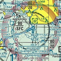
| Sectional chart |
|---|
|
CAUTION: Diagram may not be current
 Download PDF
of official airport diagram from the FAA
| Airport distance calculator |
|---|
|
|
| Sunrise and sunset |
|---|
|
Times for 30-Jun-2026
| | Local
(UTC-5) | | Zulu
(UTC) |
|---|
| Morning civil twilight | | 04:50 | | 09:50 |
| Sunrise | | 05:24 | | 10:24 |
| Sunset | | 20:36 | | 01:36 |
| Evening civil twilight | | 21:10 | | 02:10 |
|
| Current date and time |
|---|
| Zulu (UTC) | 01-Jul-2026 04:03:28 |
|---|
| Local (UTC-5) | 30-Jun-2026 23:03:28 |
|---|
|
| METAR |
|---|
| KRFD | 010354Z 20012KT 10SM CLR 28/24 A2992 RMK AO2 SLP126 T02780239
|
KRPJ
19nm S | 010355Z AUTO 18005KT 7SM CLR 25/23 A2994 RMK AO2 T02480233
|
|
| TAF |
|---|
| KRFD | 302100Z 3021/0118 22017G27KT P6SM SCT030 BKN250 FM010130 20010KT P6SM SKC FM011200 22011G17KT P6SM SCT020
|
|
| NOTAMs |
|---|
NOTAMs are issued by the DoD/FAA and will open in a separate window not controlled by AirNav.
|
|


