FAA INFORMATION EFFECTIVE 16 APRIL 2026
Location
| FAA Identifier: | TSG |
| Lat/Long: | 63-22-26.6297N 143-19-44.3631W
63-22.443828N 143-19.739385W
63.3740638,-143.3289898
(estimated) |
| Elevation: | 1559 ft. / 475 m (estimated) |
| Variation: | 29E (1985) |
| From city: | 1 mile S of TANACROSS, AK |
| Time zone: | UTC -8 (UTC -9 during Standard Time) |
| Zip code: | 99776 |
Airport Operations
| Airport use: | Open to the public |
| Activation date: | 07/1947 |
| Control tower: | no |
| ARTCC: | ANCHORAGE CENTER |
| FSS: | NORTHWAY FLIGHT SERVICE STATION [907-778-2219] |
| Alternate FSS: | FAI FAIRBANKS FLIGHT SERVICE STATION [1-866-248-6516] |
| NOTAMs facility: | ORT (NOTAM-D service available) |
| Attendance: | UNATNDD |
| Wind indicator: | yes |
| Segmented circle: | no |
Airport Communications
| CTAF: | 122.8 |
| WX AWOS-3P at 6K8 (10 nm E): | 118.1 (907-269-2706) |
Airport Services
Runway Information
Runway 6/24
| Dimensions: | 4963 x 150 ft. / 1513 x 46 m |
| Surface: | asphalt, in poor condition
CRACKED WITH VEGETATION. |
| Runway edge markings: | FADED.
YELLOW NRS & CNTRLN. |
| RUNWAY 6 | | RUNWAY 24 |
| Latitude: | 63-22.472667N | | 63-22.511167N |
| Longitude: | 143-20.227500W | | 143-18.415167W |
| Elevation: | 1547.0 ft. | | 1554.0 ft. |
| Traffic pattern: | left | | left |
| Markings: | NSTD, in poor condition | | NSTD, in poor condition |
| Runway end identifier lights: | no | | no |
| Touchdown point: | yes, no lights | | yes, no lights |
| Obstructions: | 50 ft. trees, 990 ft. from runway, 225 ft. right of centerline, 15:1 slope to clear | | 43 ft. trees, 200 ft. from runway, 200 ft. left of centerline |
Runway 12/30
| Dimensions: | 4871 x 150 ft. / 1485 x 46 m |
| Surface: | asphalt, in poor condition
CRACKED WITH VEGETATION. |
| Runway edge markings: | FADED.
YELLOW NRS & CNTRLN. |
| RUNWAY 12 | | RUNWAY 30 |
| Latitude: | 63-22.730500N | | 63-22.059167N |
| Longitude: | 143-20.648333W | | 143-19.682333W |
| Elevation: | 1544.0 ft. | | 1559.0 ft. |
| Traffic pattern: | left | | left |
| Markings: | NSTD, in poor condition | | NSTD, in poor condition |
| Runway end identifier lights: | no | | no |
| Obstructions: | 56 ft. trees, 630 ft. from runway, 7:1 slope to clear
ROAD XS APCH 60 FT FM THR; RIVER XS APCH 100 FT FM RWY END. | | 31 ft. trees, 200 ft. from runway, 135 ft. left and right of centerline |
Helipad H1
| Dimensions: | 90 x 95 ft. / 27 x 29 m |
| Surface: | asphalt |
| Latitude: | 63-22.341000N | | |
| Longitude: | 143-20.469000W | | |
| Elevation: | 1556.0 ft. | | |
| Traffic pattern: | left | | left |
Helipad H2
| Dimensions: | 90 x 95 ft. / 27 x 29 m |
| Surface: | asphalt |
| Latitude: | 63-22.353000N | | |
| Longitude: | 143-20.486833W | | |
| Elevation: | 1556.0 ft. | | |
| Traffic pattern: | left | | left |
Airport Ownership and Management from official FAA records
| Ownership: | Publicly-owned |
| Owner: | BUREAU OF LAND MANAGEMENT
1150 UNIVERSITY AVE
FAIRBANKS, AK 99709-3844
Phone 907-474-2200
STEESE/WHITE MOUNTAIN DISTRICT. |
| Manager: | LANORE HEPPLER
1150 UNIVERSITY AVE
FAIBANKS, AK 99709
Phone 907-474-2320 |
Additional Remarks
| A30A-30 | APCH: 280 FT SWATH CUT THRU TREES. |
| A30A-24 | APCH: 300 FT SWATH CUT THRU TREES. |
| - | AIR OPS & FIRE SUPPORT SUMMER MONTHS. RWY MAINT NA IN WINTER. |
| - | SUAIS - 125.3/126.3/1-800-758-8723. |
Instrument Procedures
There are no published instrument procedures at TSG.
Some nearby airports with instrument procedures:
PFTO - Tok Junction Airport (10 nm E)
PAOR - Northway Airport (45 nm SE)
PABI - Allen Army Airfield (74 nm NW)
PAGK - Gulkana Airport (94 nm SW)
|
|

Road maps at:
MapQuest
Bing
Google
| Aerial photo |
|---|
WARNING: Photo may not be current or correct
 Photo taken 14-Jun-2008
from the southwest
Photo taken 14-Jun-2008
from the southwest
Do you have a better or more recent aerial photo of Tanacross Airport that you would like to share? If so, please send us your photo.
|
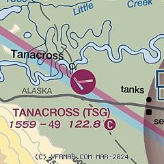
| Sectional chart |
|---|
|
| Airport distance calculator |
|---|
|
|
| Sunrise and sunset |
|---|
|
Times for 08-May-2026
| | Local
(UTC-8) | | Zulu
(UTC) |
|---|
| Morning civil twilight | | 03:33 | | 11:33 |
| Sunrise | | 04:48 | | 12:48 |
| Sunset | | 22:11 | | 06:11 |
| Evening civil twilight | | 23:27 | | 07:27 |
|
| Current date and time |
|---|
| Zulu (UTC) | 09-May-2026 04:59:32 |
|---|
| Local (UTC-8) | 08-May-2026 20:59:32 |
|---|
|
| METAR |
|---|
PFTO
10nm E | 090356Z AUTO 19005KT 10SM OVC090 11/M04 A2949 RMK AO2 SLP502 T01061044 $
|
|
| TAF |
|---|
PAOR
45nm SE | 081720Z 0818/0918 VRB03KT P6SM BKN100 FM090500 VRB04KT P6SM OVC050 PROB30 0909/0914 P6SM -RA OVC025
|
|
| NOTAMs |
|---|
NOTAMs are issued by the DoD/FAA and will open in a separate window not controlled by AirNav.
|
|

