FAA INFORMATION EFFECTIVE 14 MAY 2026
Location
| FAA Identifier: | X43 |
| Lat/Long: | 36-01-45.1280N 101-49-43.6160W
36-01.752133N 101-49.726933W
36.0292022,-101.8287822
(estimated) |
| Elevation: | 3507 ft. / 1069 m (estimated) |
| Variation: | 09E (1985) |
| From city: | 1 mile NW of SUNRAY, TX |
| Time zone: | UTC -5 (UTC -6 during Standard Time) |
| Zip code: | 79086 |
Airport Operations
| Airport use: | Open to the public |
| Activation date: | 11/1960 |
| Control tower: | no |
| ARTCC: | ALBUQUERQUE CENTER |
| FSS: | FORT WORTH FLIGHT SERVICE STATION |
| NOTAMs facility: | FTW (NOTAM-D service available) |
| Attendance: | IREG |
| Wind indicator: | lighted |
| Segmented circle: | no |
| Lights: | SS-SR |
Airport Communications
| CTAF: | 122.9 |
| WX AWOS-3PT at DUX (14 nm SW): | 118.075 (806-934-3390) |
Nearby radio navigation aids
| VOR radial/distance | | VOR name | | Freq | | Var |
|---|
| DHTr084/34.9 | | DALHART VORTAC | | 112.00 | | 12E |
Airport Services
| Airframe service: | NONE |
| Powerplant service: | NONE |
| Bottled oxygen: | NONE |
| Bulk oxygen: | NONE |
Runway Information
Runway 17/35
| Dimensions: | 3250 x 50 ft. / 991 x 15 m |
| Surface: | asphalt, in fair condition |
| Weight bearing capacity: | |
| Runway edge lights: | non-standard
LOW INTST SOLAR LGTS. |
| RUNWAY 17 | | RUNWAY 35 |
| Traffic pattern: | left | | left |
| Markings: | basic, in fair condition | | basic, in fair condition |
| Obstructions: | 17 ft. road, 201 ft. from runway, 20 ft. left of centerline
17 FT RD, 0 FT DSTC, 60 FT L. | | 40 ft. pline, 219 ft. from runway, 118 ft. right of centerline
4 FT POLES, 108 FT DSTC, 5 FT L; 17 FT ROAD, 146 FT DSTC, 140 FT L/R. |
Runway 2/20
| Dimensions: | 3760 x 50 ft. / 1146 x 15 m |
| Surface: | gravel/dirt, in poor condition
RWY SFC ROUGH, CROPS AT RWY EDGE. |
| RUNWAY 2 | | RUNWAY 20 |
| Traffic pattern: | left | | left |
| Obstructions: | 30 ft. pline, 29 ft. from runway, 125 ft. right of centerline | | 15 ft. road, 60 ft. from runway, 131 ft. left of centerline, 4:1 slope to clear |
Airport Ownership and Management from official FAA records
| Ownership: | Publicly-owned |
| Owner: | CITY OF SUNRAY
PO BOX 250
SUNRAY, TX 79086
Phone 806-948-4111 |
| Manager: | KJ PERRY
PO BOX 250
SUNRAY, TX 79086
Phone 806-948-4111
CITY/ARPT MGR. |
Additional Remarks
| - | RWY 17/35 HNGRS, PARKED VEHICLES, PIPE SUPPLIES, GRAVEL PILES & ACFT OBST PRIM SFC. |
| - | 10 FT AGL GAS WELL LCTD 375 FT EAST OF SOUTH END RWY 02/20. |
| - | FOR CD CTC ALBUQUERQUE ARTCC AT 505-856-4861. |
| - | RWY 35 ALSO 40 FT PLINE, 220 FT DSTC, 150 FT L/R; 25 FT RR 265 FT DSTC, 155 L/R. |
| - | RWY 35 ALSO 40 FT PLINE, 219 FT DSTC, 155 FT L, 118 FT R; 25 FT RR, 265 FT DSTC, 0 FT B. |
| - | RWY 17/35 ENDS MKD WITH TWO 5 FT "L" SHAPED CONCRETE CURBS. |
Instrument Procedures
There are no published instrument procedures at X43.
Some nearby airports with instrument procedures:
KDUX - Moore County Airport (14 nm SW)
E19 - Gruver Municipal Airport (23 nm NE)
KBGD - Hutchinson County Airport (29 nm SE)
E42 - Major Samuel B Cornelius Field Airport (33 nm E)
KDHT - Dalhart Municipal Airport (35 nm W)
|
|

Road maps at:
MapQuest
Bing
Google
| Aerial photo |
|---|
WARNING: Photo may not be current or correct
 Taken in the Summer of 2007
Do you have a better or more recent aerial photo of Sunray Airport that you would like to share? If so, please send us your photo.
|
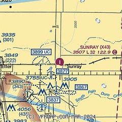
| Sectional chart |
|---|
|
| Airport distance calculator |
|---|
|
|
| Sunrise and sunset |
|---|
|
Times for 05-Jun-2026
| | Local
(UTC-5) | | Zulu
(UTC) |
|---|
| Morning civil twilight | | 06:02 | | 11:02 |
| Sunrise | | 06:32 | | 11:32 |
| Sunset | | 21:00 | | 02:00 |
| Evening civil twilight | | 21:30 | | 02:30 |
|
| Current date and time |
|---|
| Zulu (UTC) | 05-Jun-2026 13:16:21 |
|---|
| Local (UTC-5) | 05-Jun-2026 08:16:21 |
|---|
|
| METAR |
|---|
KDUX
14nm SW | 051255Z AUTO 22011KT 10SM CLR 20/16 A2996 RMK AO2
|
|
| TAF |
|---|
KDHT
35nm W | 051120Z 0512/0612 20008KT P6SM FEW250 FM051700 18012G22KT P6SM FEW250 FM060000 16011KT P6SM BKN150
|
KGUY
42nm N | 051120Z 0512/0612 20009KT P6SM FEW250 FM051700 18012G22KT P6SM FEW250 FM052200 18011KT P6SM FEW250
|
|
| NOTAMs |
|---|
NOTAMs are issued by the DoD/FAA and will open in a separate window not controlled by AirNav.
|
|

