FAA INFORMATION EFFECTIVE 05 SEPTEMBER 2024
Location
| FAA Identifier: | VUJ |
| Lat/Long: | 35-25-00.0980N 080-09-02.8480W
35-25.001633N 080-09.047467W
35.4166939,-80.1507911
(estimated) |
| Elevation: | 609 ft. / 185.6 m (surveyed) |
| Variation: | 06W (1985) |
| From city: | 4 miles NE of ALBEMARLE, NC |
| Time zone: | UTC -4 (UTC -5 during Standard Time) |
| Zip code: | 28127 |
Airport Operations
| Airport use: | Open to the public |
| Activation date: | 01/1979 |
| Control tower: | yes |
| ARTCC: | ATLANTA CENTER |
| FSS: | RALEIGH FLIGHT SERVICE STATION |
| NOTAMs facility: | VUJ (NOTAM-D service available) |
| Attendance: | 0800-1800 |
| Pattern altitude: | TPA: HEL 500 FT (1200 FT MSL), SMALL FW 1000 FT (1700 MSL), LRG/HVY 1500 FT (2200 FT MSL), OVHD 1500 FT (2200 FT MSL) OR AS ASGND BY TWR. |
| Wind indicator: | lighted |
| Segmented circle: | yes |
| Lights: | ACTVT REIL RWY 04R & 22L; HIRL RWY 04R/22L; MIRL RWY 04L/22R - CTAF. PAPI RWY 04R & 22L ON DRG TWR OPN, OTHER TIMES - CTAF. |
| Beacon: | white-green (lighted land airport)
Operates sunset to sunrise. |
Airport Communications
| CTAF: | 126.275 |
| WX AWOS-3: | 128.175 (704-986-2097) |
| STANLY COUNTY GROUND: | 121.75 254.375 [1300-2230Z++ OR BY NOTAM.] |
| STANLY COUNTY TOWER: | 126.275 291.9 [1300-2230Z++ OR BY NOTAM.] |
| CHARLOTTE APPROACH: | 128.325 |
| CHARLOTTE DEPARTURE: | 128.325 |
| CLEARANCE DELIVERY: | 121.75 254.375 |
| BARMY DP: | 128.325 |
| BEAVY DP: | 128.325 |
| BOBZY DP: | 128.325 |
| ESTRR DP: | 128.325 |
| ICONS DP: | 128.325 |
| JOJJO DP: | 128.325 |
| JOOLS STAR: | 135.6 |
| KABEE STAR: | 126.15 |
| KERMIT DP: | 128.325 |
| KILNS DP: | 128.325 |
| KNIGHTS DP: | 128.325 |
| KRITR DP: | 128.325 |
| KWEEN DP: | 128.325 |
| LILLS DP: | 128.325 |
| NASCR STAR: | 128.325 |
| WEAZL DP: | 128.325 |
| WX AWOS-3 at HBI (19 nm NE): | 119.275 (336-626-7933) |
Nearby radio navigation aids
| VOR radial/distance | | VOR name | | Freq | | Var |
|---|
| SDZr297/30.1 | | SANDHILLS VORTAC | | 111.80 | | 03W |
| LIBr231/35.4 | | LIBERTY VORTAC | | 113.00 | | 03W |
| GSOr196/38.7 | | GREENSBORO VORTAC | | 116.20 | | 03W |
| NDB name | | Hdg/Dist | | Freq | | Var | | ID |
|---|
| ALLER | | 223/5.5 | | 346 | | 06W | | VU | ...- ..- |
Airport Services
| Fuel available: | 100LL JET-A+ JET-A1+
100LL:100LL AVBL SELF SVC H24 WITH CREDIT CARD. |
| Parking: | hangars and tiedowns |
| Airframe service: | MAJOR |
| Powerplant service: | MAJOR |
| Bottled oxygen: | NONE |
| Bulk oxygen: | LOW |
Runway Information
Runway 4R/22L
| Dimensions: | 5499 x 100 ft. / 1676 x 30 m |
| Surface: | asphalt/grooved, in excellent condition |
| Weight bearing capacity: | |
| Runway edge lights: | high intensity |
| RUNWAY 4R | | RUNWAY 22L |
| Latitude: | 35-24.558567N | | 35-25.280640N |
| Longitude: | 080-09.389363W | | 080-08.719998W |
| Elevation: | 608.9 ft. | | 577.3 ft. |
| Traffic pattern: | left | | left |
| Runway heading: | 043 magnetic, 037 true | | 223 magnetic, 217 true |
| Markings: | precision, in good condition | | precision, in good condition |
| Visual slope indicator: | 2-light PAPI on left (3.00 degrees glide path) | | 2-light PAPI on left (3.00 degrees glide path) |
| Runway end identifier lights: | yes | | yes |
| Touchdown point: | yes, no lights | | yes, no lights |
| Instrument approach: | | | ILS |
| Obstructions: | 32 ft. trees, 375 ft. from runway, 488 ft. left of centerline, 5:1 slope to clear | | 137 ft. trees, 4194 ft. from runway, 176 ft. right of centerline, 29:1 slope to clear |
Runway 4L/22R
| Dimensions: | 3501 x 75 ft. / 1067 x 23 m |
| Surface: | asphalt, in excellent condition |
| Weight bearing capacity: | |
| Runway edge lights: | medium intensity |
| RUNWAY 4L | | RUNWAY 22R |
| Latitude: | 35-24.900662N | | 35-25.360298N |
| Longitude: | 080-09.249112W | | 080-08.823057W |
| Elevation: | 592.3 ft. | | 580.9 ft. |
| Traffic pattern: | left | | left |
| Runway heading: | 043 magnetic, 037 true | | 223 magnetic, 217 true |
| Markings: | basic, in good condition | | basic, in good condition |
| Touchdown point: | yes, no lights | | yes, no lights |
| Obstructions: | 23 ft. fence, 411 ft. from runway, 301 ft. left of centerline, 9:1 slope to clear
10 FT HILL 0-200 FT FROM THR 200 FT LEFT OF CNTRLN. | | 32 ft. trees, 793 ft. from runway, 270 ft. right of centerline, 18:1 slope to clear |
Airport Ownership and Management from official FAA records
| Ownership: | Publicly-owned |
| Owner: | STANLY COUNTY
43222 LOWDER AVIATION PARKWAY
NEW LONDON, NC 28127
Phone 704-982-9013 |
| Manager: | RANDY SHANK
43222 LOWDER AVIATION PARKWAY
NEW LONDON, NC 28127
Phone 704-982-9013 |
Additional Remarks
| - | 959 FT MSL LGTD TWR 1.5NW. |
| - | MISC: REGIONAL TRAINING SITE (RTS) SUPPORT COORD THRU 145 AW/CE DSN 231-4229. |
| - | ANG: PPR ONLY IF RON ON ANG RAMP AND FBO RAMP, 145 AW BASOPS DSN 704-422-2551. |
| - | HEAVY PARACHUTE JUMPING NORTH END OF RWY 22L/R. |
| - | FOR CD WHEN ATCT IS CLSD CTC CHARLOTTE APCH AT 704-359-0241. |
| - | FBO OPERATIONAL HRS 0800-1800. |
| - | MILITARY FUEL - A+ (C704-982-9013, 1300-0000Z++, OT C704-984-3542 OR C704-961-8964) (NC-100LL). FUEL AVBL FROM FBO 1400-2200Z++, OTHER TIMES PPR, C704-982-9013. |
| - | RSTD: ANG RAMP RSTD TO MIL USE ONLY WITH PPR. CTC 235ATCS/ATM DSN 484-2552, C704-422-2551 OR C704-763-4633 AFTER DUTY HOURS. |
| - | CAUTION: BE ALERT FOR HIGH SPEED LOW LEVEL MIL ACFT IN VCNTY. FRQ NGT MIL OPR. FREQ ASSAULT OPS TO RWY 22R. DEER AND BIRD HAZARD. |
Instrument Procedures
NOTE: All procedures below are presented as PDF files. If you need a reader for these files, you should download the free Adobe Reader.NOT FOR NAVIGATION. Please procure official charts for flight.
FAA instrument procedures published for use from 05 September 2024 at 0901Z to 03 October 2024 at 0900Z.
STARs - Standard Terminal Arrivals |
|---|
| JOOLS ONE (RNAV) | |
download (273KB) |
| KABEE THREE (RNAV) | |
download (152KB) |
| NASCR FOUR | |
download (212KB) |
IAPs - Instrument Approach Procedures |
|---|
| ILS OR LOC RWY 22L | |
download (234KB) |
| RNAV (GPS) RWY 04R | |
download (296KB) |
| RNAV (GPS) RWY 22L | |
download (262KB) |
| NDB RWY 22L | |
download (239KB) |
| Radar Approach Procedures available | |
download (158KB) |
| NOTE: Special Alternate Minimums apply | |
download (143KB) |
Departure Procedures |
|---|
| BARMY FIVE (RNAV) | |
download (206KB) |
| BEAVY SIX (RNAV) | |
download (191KB) |
| BOBZY FIVE (RNAV) | |
download (210KB) |
| ESTRR FIVE (RNAV) | |
download (176KB) |
| ICONS FIVE (RNAV) | |
download (179KB) |
| JOJJO FIVE (RNAV) | |
download (231KB) |
| KERMIT FOUR | |
2 pages:
[1] [2] (384KB) |
| KILNS FIVE (RNAV) | |
download (183KB) |
| KNIGHTS THREE | |
2 pages:
[1] [2] (374KB) |
| KRITR SIX (RNAV) | |
download (179KB) |
| KWEEN FIVE (RNAV) | |
download (180KB) |
| LILLS THREE (RNAV) | |
download (161KB) |
| WEAZL FIVE (RNAV) | |
download (160KB) |
| NOTE: Special Take-Off Minimums/Departure Procedures apply | |
download (388KB) |
Other nearby airports with instrument procedures:
43A - Montgomery County Airport (18 nm E)
KHBI - Asheboro Regional Airport (19 nm NE)
KRUQ - Mid-Carolina Regional Airport (23 nm NW)
KEXX - Davidson County Executive Airport (23 nm N)
KAFP - Anson County Airport - Jeff Cloud Field (24 nm S)
|
|

Road maps at:
MapQuest
Bing
Google
| Aerial photo |
|---|
WARNING: Photo may not be current or correct
 Photo courtesy of Pilot's View Photography
Photo taken 22-Jan-2013
looking northeast.
Photo courtesy of Pilot's View Photography
Photo taken 22-Jan-2013
looking northeast.
Do you have a better or more recent aerial photo of Stanly County Airport that you would like to share? If so, please send us your photo.
|
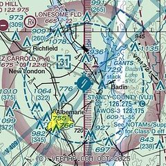
| Sectional chart |
|---|
|
| Airport distance calculator |
|---|
|
|
| Sunrise and sunset |
|---|
|
Times for 27-Sep-2024
| | Local
(UTC-4) | | Zulu
(UTC) |
|---|
| Morning civil twilight | | 06:49 | | 10:49 |
| Sunrise | | 07:14 | | 11:14 |
| Sunset | | 19:08 | | 23:08 |
| Evening civil twilight | | 19:34 | | 23:34 |
|
| Current date and time |
|---|
| Zulu (UTC) | 27-Sep-2024 14:41:24 |
|---|
| Local (UTC-4) | 27-Sep-2024 10:41:24 |
|---|
|
| METAR |
|---|
| KVUJ | 271405Z AUTO 14014G23KT 10SM VCTS OVC013 25/24 A2957 RMK AO2 LTG DSNT W T02520240
|
KHBI
19nm NE | 271405Z AUTO 12007KT 100V160 10SM SCT010 BKN024 OVC043 24/23 A2958 RMK AO2 T02400232
|
|
| TAF |
|---|
KCLT
41nm W | 271422Z 2714/2818 14025G40KT P6SM -RA BKN016 OVC035 WS020/15055KT TEMPO 2714/2716 15028G45KT 3SM SHRA OVC015 FM271700 18019G33KT P6SM OVC012 FM272000 19014G27KT P6SM OVC020 FM272300 18009KT P6SM SCT120 SCT250
|
KGSO
42nm N | 271123Z 2712/2812 10020G40KT 2SM RA OVC008 WS020/14055KT TEMPO 2713/2716 1SM +RA OVC006 FM271600 12020G35KT 2SM +RA BR OVC008 FM271800 16015G22KT 4SM -SHRA BR BKN012 FM272000 19015G22KT P6SM VCSH BKN015 FM272300 18008KT P6SM BKN040
|
KINT
43nm N | 271123Z 2712/2812 10020G40KT 2SM RA OVC008 WS020/14055KT TEMPO 2712/2715 1SM +RA OVC006 FM271500 12020G35KT 2SM +RA BR OVC008 FM271800 16014G22KT 4SM -SHRA BKN012 FM272100 18010G18KT P6SM VCSH BKN015 FM272200 18008KT P6SM BKN035
|
|
| NOTAMs |
|---|
NOTAMs are issued by the DoD/FAA and will open in a separate window not controlled by AirNav.
|
|


