FAA INFORMATION EFFECTIVE 30 OCTOBER 2025
Location
| FAA Identifier: | 06FA |
| Lat/Long: | 26-54-29.3510N 080-19-42.2905W
26-54.489183N 080-19.704842W
26.9081531,-80.3284140
(estimated) |
| Elevation: | 28 ft. / 9 m (estimated) |
| Variation: | 05W (2000) |
| From city: | 24 miles S of JUPITER, FL |
| Time zone: | UTC -5 (UTC -4 during Daylight Saving Time) |
| Zip code: | 33478 |
Airport Operations
| Airport use: | Private use. Permission required prior to landing |
| Activation date: | 04/1977 |
| Control tower: | yes |
| ARTCC: | MIAMI CENTER |
| FSS: | MIAMI FLIGHT SERVICE STATION |
| NOTAMs facility: | FDC (NOTAM-D service not available) |
| Attendance: | MON -FRI 0800-1600
ATTENDED MON-FRI EXCP HOLS. |
| Wind indicator: | yes |
| Segmented circle: | no |
| Lights: | ATC CTL |
| Beacon: | white-green (lighted land airport)
ATC-CTL |
Airport Communications
| GWINN GROUND: | 121.65 279.25 [0800-1600 MON-FRI.] |
| GWINN TOWER: | 120.4 279.25 [0800-1600 MON-FRI.] |
| CLMNT STAR: | 124.6 |
| CPTAN STAR: | 124.6 |
| MELBOURNE STAR: | 124.6 |
| STOOP STAR: | 124.6 |
| TTYLR STAR: | 125.2 |
| VUUDU STAR: | 127.35 |
| WX AWOS-3 at F45 (7 nm SE): | 119.975 (561-630-6932) |
| WX AWOS-3 at SUA (17 nm N): | 134.475 (772-692-7399) |
| WX ASOS at PBI (18 nm SE): | 123.75 (561-683-2548) |
Nearby radio navigation aids
| VOR radial/distance | | VOR name | | Freq | | Var |
|---|
| PBIr320/18.8 | | PALM BEACH VORTAC | | 115.70 | | 03W |
| NDB name | | Hdg/Dist | | Freq | | Var | | ID |
|---|
| UNITED | | at field | | 405 | | 05W | | UTX | ..- - -..- |
Airport Services
Runway Information
Runway 10/28
| Dimensions: | 7003 x 150 ft. / 2135 x 46 m |
| Surface: | asphalt |
| Weight bearing capacity: | |
| Runway edge lights: | high intensity |
| RUNWAY 10 | | RUNWAY 28 |
| Latitude: | 26-54.489017N | | 26-54.489350N |
| Longitude: | 080-20.349467W | | 080-19.060217W |
| Elevation: | 27.6 ft. | | 27.7 ft. |
| Traffic pattern: | left | | right |
| Runway heading: | 095 magnetic, 090 true | | 275 magnetic, 270 true |
| Displaced threshold: | 241 ft. | | 241 ft. |
| Markings: | precision, in good condition | | nonprecision, in good condition |
| Visual slope indicator: | 4-light PAPI on left (3.00 degrees glide path) | | 4-light PAPI on left (3.00 degrees glide path) |
| Runway end identifier lights: | yes | | yes |
| Touchdown point: | yes, no lights | | yes, no lights |
| Instrument approach: | ILS/DME | | |
| Obstructions: | trees, 400 ft. from runway | | none |
Airport Ownership and Management from official FAA records
| Ownership: | Privately-owned |
| Owner: | SIKORSKY AIRCRAFT CORP
15270 ENDEAVOR DR
JUPITER, FL 33478-6414
Phone 561-775-5450 |
| Manager: | JAMES SAULNIER
15270 ENDEAVOR DR
JUPITER, FL 33478-6414
Phone 561-345-7377 |
Additional Remarks
| - | OPEN ONLY TO CIVIL & MIL ACFT HAVING BUSINESS WITH UNITED TECHNOLOGIES CORPORATION OR ITS DIVISIONS. PPR CTC ATCT C561-775-5450. |
| - | ARPT BCN OPERS ONLY WHEN ARPT IS ATTENDED. |
| - | FUEL: NOT FOR PUBLIC SALE. A, J5 J8 FLUID - SP. |
| - | JASU: (4 HOBART STARTING UNITS 28.5V/750 AMPS.) |
| - | MISC: COPTER OPR. VERT TKOF UP TO 3000'. POSSIBLE VERT JET TURBULENCE WITHIN 2 NM OF APCH END RWY 10. CLASS D AIRSPACE EFF 1200-2300Z++ MON-FRI, OT CLASS G. |
| - | BIRDS AND WILDLIFE ON AND INVOF ARPT. |
| - | WHEN ATCT CLSD, FOR CD CTC PALM BEACH APCH AT 561-275-1430 |
Instrument Procedures
NOTE: All procedures below are presented as PDF files. If you need a reader for these files, you should download the free Adobe Reader.NOT FOR NAVIGATION. Please procure official charts for flight.
FAA instrument procedures published for use from 30 October 2025 at 0901Z to 27 November 2025 at 0900Z.
STARs - Standard Terminal Arrivals |
|---|
| CLMNT TWO (RNAV) | |
2 pages:
[1] [2] (272KB) |
| CLMNT TWO (RNAV), CONT.2 | |
download (202KB) |
| CPTAN THREE (RNAV) | |
2 pages:
[1] [2] (365KB) |
| CPTAN THREE (RNAV), CONT.2 | |
download (261KB) |
| MELBOURNE TWO | |
download (118KB) |
| STOOP THREE | |
download (125KB) |
| TTYLR FOUR | |
download (162KB) |
| VUUDU ONE (RNAV) | |
2 pages:
[1] [2] (434KB) |
| VUUDU ONE (RNAV), CONT.2 | |
download (192KB) |
Other nearby airports with instrument procedures:
F45 - North Palm Beach County General Aviation Airport (7 nm SE)
KSUA - Witham Field Airport (17 nm N)
KPBI - Palm Beach International Airport (18 nm SE)
KPHK - Palm Beach County Glades Airport (21 nm W)
KLNA - Palm Beach County Park Airport (23 nm SE)
|
|

Road maps at:
MapQuest
Bing
Google
| Aerial photo |
|---|
WARNING: Photo may not be current or correct

Do you have a better or more recent aerial photo of William P Gwinn Airport that you would like to share? If so, please send us your photo.
|
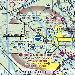
| Sectional chart |
|---|
|
| Airport distance calculator |
|---|
|
|
| Sunrise and sunset |
|---|
|
Times for 05-Nov-2025
| | Local
(UTC-5) | | Zulu
(UTC) |
|---|
| Morning civil twilight | | 06:11 | | 11:11 |
| Sunrise | | 06:35 | | 11:35 |
| Sunset | | 17:35 | | 22:35 |
| Evening civil twilight | | 17:59 | | 22:59 |
|
| Current date and time |
|---|
| Zulu (UTC) | 05-Nov-2025 19:13:36 |
|---|
| Local (UTC-5) | 05-Nov-2025 14:13:36 |
|---|
|
| METAR |
|---|
KF45
7nm SE | 051820Z AUTO 09006KT 10SM FEW046 SCT060 27/15 A3016 RMK AO2
|
KSUA
18nm N | 051850Z 10008KT 10SM SCT043 BKN055 27/18 A3015
|
KPBI
18nm SE | 051853Z 09010KT 10SM SCT043 BKN050 BKN250 27/17 A3016 RMK AO2 SLP212 T02670167 $
|
|
| TAF |
|---|
KSUA
18nm N | 051738Z 0518/0618 09009KT P6SM SCT045 FM060000 07005KT P6SM FEW040 SCT180 FM061400 04005KT P6SM FEW040 BKN200 FM061700 05009KT P6SM SCT040 BKN170 AMD NOT SKED
|
KPBI
18nm SE | 051720Z 0518/0618 08012G18KT P6SM SCT040 BKN250 FM060000 06006KT P6SM SCT040 BKN250
|
|
| NOTAMs |
|---|
NOTAMs are issued by the DoD/FAA and will open in a separate window not controlled by AirNav.
|
|


