FAA INFORMATION EFFECTIVE 09 JULY 2026
Location
| FAA Identifier: | 0D8 |
| Lat/Long: | 44-59-11.8000N 099-57-10.4000W
44-59.196667N 099-57.173333W
44.9866111,-99.9528889
(estimated) |
| Elevation: | 2061.8 ft. / 628.4 m (surveyed) |
| Variation: | 08E (1995) |
| From city: | 1 mile S of GETTYSBURG, SD |
| Time zone: | UTC -5 (UTC -6 during Standard Time) |
| Zip code: | 57442 |
Airport Operations
| Airport use: | Open to the public |
| Activation date: | 12/1946 |
| Control tower: | no |
| ARTCC: | MINNEAPOLIS CENTER |
| FSS: | HURON FLIGHT SERVICE STATION |
| NOTAMs facility: | HON (NOTAM-D service available) |
| Attendance: | MON-FRI DAYLIGHT HOURS, ALL SUN IREG |
| Wind indicator: | lighted |
| Segmented circle: | no |
| Lights: | ACTVT PAPI RWY 13 & 31; LIRL RWY 13/31 - CTAF. |
| Beacon: | white-green (lighted land airport)
Operates sunset to sunrise. |
Airport Communications
| CTAF/UNICOM: | 122.8 |
| WX AWOS-3P: | 119.275 (605-765-0132) |
| WX AWOS-3P at 98D (18 nm S): | 120.0 |
- AUTOMATED UNICOM.
- APCH/DEP SVC PRVDD BY MINNEAPOLIS ARTCC ON FREQS 125.1/269.1 (PIERRE RCAG).
Nearby radio navigation aids
| VOR radial/distance | | VOR name | | Freq | | Var |
|---|
| PIRr003/36.6 | | PIERRE VORTAC | | 113.75 | | 11E |
Airport Services
| Fuel available: | 100LL JET-A |
| Parking: | hangars and tiedowns |
| Airframe service: | MINOR |
| Powerplant service: | MINOR |
| Bottled oxygen: | NONE |
| Bulk oxygen: | NONE |
Runway Information
Runway 13/31
| Dimensions: | 4400 x 75 ft. / 1341 x 23 m |
| Surface: | asphalt, in fair condition |
| Weight bearing capacity: | |
| Runway edge lights: | low intensity |
| RUNWAY 13 | | RUNWAY 31 |
| Latitude: | 44-59.454400N | | 44-58.873498N |
| Longitude: | 099-57.400583W | | 099-56.791770W |
| Elevation: | 2058.8 ft. | | 2054.5 ft. |
| Traffic pattern: | left | | left |
| Runway heading: | 135 magnetic, 143 true | | 315 magnetic, 323 true |
| Markings: | nonprecision, in good condition | | nonprecision, in good condition |
| Visual slope indicator: | 2-light PAPI on left (3.00 degrees glide path) | | 2-light PAPI on left (3.00 degrees glide path) |
| Runway end identifier lights: | no | | no |
| Touchdown point: | yes, no lights | | yes, no lights |
Runway 4/22
| Dimensions: | 2485 x 155 ft. / 757 x 47 m |
| Surface: | turf, in good condition |
| Runway edge markings: | 04/22 MKD WITH BLACK AND W CONES. |
| RUNWAY 4 | | RUNWAY 22 |
| Latitude: | 44-59.134245N | | 44-59.378563N |
| Longitude: | 099-57.539552W | | 099-57.077493W |
| Elevation: | 2049.1 ft. | | 2061.6 ft. |
| Traffic pattern: | left | | left |
| Runway heading: | 045 magnetic, 053 true | | 225 magnetic, 233 true |
| Runway end identifier lights: | no | | no |
| Touchdown point: | yes, no lights | | yes, no lights |
Airport Ownership and Management from official FAA records
| Ownership: | Publicly-owned |
| Owner: | CITY OF GETTYSBURG
109 E. COMMERCIAL
GETTYSBURG, SD 57442
Phone 605-765-2733 |
| Manager: | GREG GERBER
109 E COMMERCIAL
GETTYSBURG, SD 57442
Phone 605-769-0075 |
Additional Remarks
| - | WILDLIFE ON AND INVOF ARPT. |
| - | FUEL AVBL 24 HR WITH CREDIT CARD. |
| - | FOR CD CTC MINNEAPOLIS ARTCC AT 651-463-5588. |
Instrument Procedures
NOTE: All procedures below are presented as PDF files. If you need a reader for these files, you should download the free Adobe Reader.NOT FOR NAVIGATION. Please procure official charts for flight.
FAA instrument procedures published for use from 09 July 2026 at 0901Z to 06 August 2026 at 0900Z.
IAPs - Instrument Approach Procedures |
|---|
| RNAV (GPS) RWY 13 | |
download (224KB) |
| RNAV (GPS) RWY 31 | |
download (213KB) |
| NOTE: Special Take-Off Minimums/Departure Procedures apply | |
download (417KB) |
Other nearby airports with instrument procedures:
98D - Onida Municipal Airport (18 nm S)
9D0 - Highmore Municipal Airport (34 nm SE)
KMBG - Mobridge Municipal Airport (39 nm NW)
KPIR - Pierre Regional Airport (39 nm S)
KMKA - Miller Municipal Airport (51 nm SE)
|
|

Road maps at:
MapQuest
Bing
Google
| Aerial photo |
|---|
WARNING: Photo may not be current or correct
 Photo by Steve Hamilton
Photo taken 20-Jun-2007
Photo by Steve Hamilton
Photo taken 20-Jun-2007
Do you have a better or more recent aerial photo of Gettysburg Municipal Airport that you would like to share? If so, please send us your photo.
|
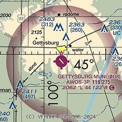
| Sectional chart |
|---|
|
| Airport distance calculator |
|---|
|
|
| Sunrise and sunset |
|---|
|
Times for 23-Jul-2026
| | Local
(UTC-5) | | Zulu
(UTC) |
|---|
| Morning civil twilight | | 05:41 | | 10:41 |
| Sunrise | | 06:16 | | 11:16 |
| Sunset | | 21:16 | | 02:16 |
| Evening civil twilight | | 21:51 | | 02:51 |
|
| Current date and time |
|---|
| Zulu (UTC) | 23-Jul-2026 22:33:45 |
|---|
| Local (UTC-5) | 23-Jul-2026 17:33:45 |
|---|
|
| TAF |
|---|
KPIR
39nm S | 231927Z 2319/2418 17015G22KT P6SM SCT030 TEMPO 2319/2322 6SM -SHRA OVC080 FM232200 15012G21KT P6SM OVC080 PROB30 2322/2324 6SM -SHRA FM240100 14011G18KT P6SM BKN080
|
KMBG
39nm NW | 231720Z 2318/2418 17015G22KT P6SM BKN120
|
|
| NOTAMs |
|---|
NOTAMs are issued by the DoD/FAA and will open in a separate window not controlled by AirNav.
|
|

