FAA INFORMATION EFFECTIVE 12 JUNE 2025
Location
| FAA Identifier: | 0H1 |
| Lat/Long: | 39-00-23.5000N 099-53-34.6000W
39-00.391667N 099-53.576667W
39.0065278,-99.8929444
(estimated) |
| Elevation: | 2438.9 ft. / 743.4 m (surveyed) |
| Variation: | 05E (2020) |
| From city: | 2 miles SW of WAKEENEY, KS |
| Time zone: | UTC -5 (UTC -6 during Standard Time) |
| Zip code: | 67672 |
Airport Operations
| Airport use: | Open to the public |
| Activation date: | 10/1977 |
| Control tower: | no |
| ARTCC: | DENVER CENTER |
| FSS: | WICHITA FLIGHT SERVICE STATION |
| NOTAMs facility: | ICT (NOTAM-D service available) |
| Attendance: | UNATNDD
FOR SVC CALL 785-743-8344. |
| Wind indicator: | lighted |
| Segmented circle: | no |
| Lights: | SS-SR |
| Beacon: | white-green (lighted land airport) |
Airport Communications
- APCH/DEP CTL SVC PRVDD BY DENVER ARTCC (ZDV) ON 132.7/226.675 (HILL CITY RCAG).
Nearby radio navigation aids
| VOR radial/distance | | VOR name | | Freq | | Var |
|---|
| HLCr126/21.7 | | HILL CITY VORTAC | | 113.70 | | 08E |
| HYSr278/30.3 | | HAYS VORTAC | | 110.40 | | 10E |
Airport Services
| Parking: | tiedowns |
| Powerplant service: | MINOR |
Runway Information
Runway 17/35
| Dimensions: | 4008 x 50 ft. / 1222 x 15 m |
| Surface: | concrete, in excellent condition |
| Weight bearing capacity: | |
| Runway edge lights: | low intensity |
| RUNWAY 17 | | RUNWAY 35 |
| Latitude: | 39-00.722068N | | 39-00.061877N |
| Longitude: | 099-53.577055W | | 099-53.574630W |
| Elevation: | 2433.9 ft. | | 2424.9 ft. |
| Traffic pattern: | right | | left |
| Runway heading: | 175 magnetic, 180 true | | 355 magnetic, 360 true |
| Displaced threshold: | no | | 316 ft. |
| Markings: | basic, in good condition | | basic, in good condition |
| Touchdown point: | yes, no lights | | yes, no lights |
| Obstructions: | 58 ft. pole, 1107 ft. from runway, 40 ft. right of centerline, 15:1 slope to clear
APCH SLOPE 36:1 TO DTHR. DTHR MKD/LGTD 462 FT FM RWY END. | | none
11 FT RD, 27 FT DSTC, 125 FT L/R. |
Airport Ownership and Management from official FAA records
| Ownership: | Publicly-owned |
| Owner: | TREGO COUNTY
216 N MAIN
WAKEENEY, KS 67672
Phone 785-743-5773 |
| Manager: | MICHAEL GHUMM
216 N MAIN
WAKEENEY, KS 67672
Phone 785-743-8344 |
Additional Remarks
| - | FOR CD CTC DENVER ARTCC AT 303-651-4257. |
| - | RWY 17/35 MIDFIELD, FOUR 5 FT PLASTIC POLES MARK PIPELINE, 50 FT FM RWY CL. |
| - | RWY 17 END, 20 ACRE LIGHTED TRUCK PARKING AREA, 185 FT E OF RWY EDGE EDGE. |
| - | RWY 35, 21 INCH CONCRETE LIGHT BASES, 28 FT FROM W. RWY EDGE, 1300 FM RWY END. |
Instrument Procedures
NOTE: All procedures below are presented as PDF files. If you need a reader for these files, you should download the free Adobe Reader.NOT FOR NAVIGATION. Please procure official charts for flight.
FAA instrument procedures published for use from 12 June 2025 at 0901Z to 10 July 2025 at 0900z.
IAPs - Instrument Approach Procedures |
|---|
| RNAV (GPS)-A | |
download (183KB) |
| RNAV (GPS)-B | |
download (189KB) |
| NOTE: Special Take-Off Minimums/Departure Procedures apply | |
download (196KB) |
Other nearby airports with instrument procedures:
1QK - Gove County Airport (16 nm W)
KHLC - Hill City Municipal Airport (23 nm N)
KHYS - Hays Regional Airport (31 nm E)
48K - Ness City Municipal Airport (32 nm S)
KRCP - Rooks County Regional Airport (34 nm NE)
|
|

Road maps at:
MapQuest
Bing
Google
| Aerial photo |
|---|
WARNING: Photo may not be current or correct
 Photo by Von Rothenberger and David Readio
Photo taken 18-Nov-2006
Photo by Von Rothenberger and David Readio
Photo taken 18-Nov-2006
Do you have a better or more recent aerial photo of Trego Wakeeney Airport that you would like to share? If so, please send us your photo.
|
| Sectional chart |
|---|
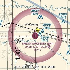
|
| Airport distance calculator |
|---|
|
|
| Sunrise and sunset |
|---|
|
Times for 27-Jun-2025
| | Local
(UTC-5) | | Zulu
(UTC) |
|---|
| Morning civil twilight | | 05:45 | | 10:45 |
| Sunrise | | 06:17 | | 11:17 |
| Sunset | | 21:08 | | 02:08 |
| Evening civil twilight | | 21:40 | | 02:40 |
|
| Current date and time |
|---|
| Zulu (UTC) | 27-Jun-2025 06:15:49 |
|---|
| Local (UTC-5) | 27-Jun-2025 01:15:49 |
|---|
|
| METAR |
|---|
KHLC
22nm N | 270553Z AUTO 08004KT 10SM CLR 22/19 A2998 RMK AO2 SLP126 T02220194 10322 20222 403330194 50009
|
KHYS
31nm E | 270556Z AUTO 19004KT 10SM CLR 24/21 A2997 RMK AO2 SLP131 60000 T02440206 10328 20228 51007 $
|
KOEL
43nm W | 270555Z AUTO 12006KT 10SM CLR 21/15 A3002 RMK AO1 T02130149 10316 20210 403250166
|
|
| TAF |
|---|
KHYS
31nm E | 270532Z 2706/2806 VRB05KT P6SM BKN150 FM272000 16012KT P6SM FEW250
|
|
| NOTAMs |
|---|
NOTAMs are issued by the DoD/FAA and will open in a separate window not controlled by AirNav.
|
|


