FAA INFORMATION EFFECTIVE 16 APRIL 2026
Location
| FAA Identifier: | 1F0 |
| Lat/Long: | 34-08-49.1000N 097-07-21.6000W
34-08.818333N 097-07.360000W
34.1469722,-97.1226667
(estimated) |
| Elevation: | 844.9 ft. / 257.5 m (surveyed) |
| Variation: | 04E (2010) |
| From city: | 1 mile SE of ARDMORE, OK |
| Time zone: | UTC -5 (UTC -6 during Standard Time) |
| Zip code: | 73401 |
Airport Operations
| Airport use: | Open to the public |
| Activation date: | 02/1950 |
| Control tower: | no |
| ARTCC: | FORT WORTH CENTER |
| FSS: | MC ALESTER FLIGHT SERVICE STATION |
| NOTAMs facility: | 1F0 (NOTAM-D service available) |
| Attendance: | MON-FRI 0800-1600, ALL SAT 0800-1200, ALL SUN ON CALL
ON CALL NUMBER: 580-223-5500. |
| Wind indicator: | lighted |
| Segmented circle: | yes |
| Lights: | DUSK-DAWN. ACTVT REIL RWY 17 & 35; MIRL RWY 17/35. - CTAF. |
| Beacon: | white-green (lighted land airport)
Operates sunset to sunrise. |
Airport Communications
| CTAF/UNICOM: | 122.7 |
| WX AWOS-3: | 118.15 (580-226-1536) |
| WX AWOS-3 at ADM (11 nm NE): | 125.6 (580-389-5078) |
- APCH/DEP CTL SVC PRVDD BY FORT WORTH ARTCC (ZFW) ON FREQS 124.75/323.0 (ARDMORE RCAG).
Nearby radio navigation aids
| VOR radial/distance | | VOR name | | Freq | | Var |
|---|
| ADMr144/4.5 | | ARDMORE VORTAC | | 116.70 | | 06E |
| NDB name | | Hdg/Dist | | Freq | | Var | | ID |
|---|
| ADDMO | | 235/10.7 | | 400 | | 06E | | AI | .- .. |
| DENISON | | 307/29.7 | | 341 | | 03E | | DNI | -.. -. .. |
Airport Services
| Fuel available: | 100LL JET-A+
100LL:FUEL AVBL 24 HRS WITH CREDIT CARD. |
| Parking: | tiedowns |
| Airframe service: | MINOR |
| Powerplant service: | MINOR |
| Bottled oxygen: | NONE |
| Bulk oxygen: | NONE |
Runway Information
Runway 17/35
| Dimensions: | 5014 x 75 ft. / 1528 x 23 m |
| Surface: | asphalt, in good condition |
| Weight bearing capacity: | |
| Runway edge lights: | medium intensity |
| RUNWAY 17 | | RUNWAY 35 |
| Latitude: | 34-09.231355N | | 34-08.404817N |
| Longitude: | 097-07.366350W | | 097-07.351985W |
| Elevation: | 839.9 ft. | | 844.9 ft. |
| Traffic pattern: | left | | right |
| Runway heading: | 175 magnetic, 179 true | | 355 magnetic, 359 true |
| Markings: | nonprecision, in fair condition | | nonprecision, in fair condition |
| Visual slope indicator: | 4-light PAPI on left (4.00 degrees glide path) | | 4-light PAPI on left (3.00 degrees glide path) |
| Runway end identifier lights: | yes | | yes |
| Touchdown point: | yes, no lights | | yes, no lights |
| Obstructions: | 36 ft. trees, lighted, 727 ft. from runway, 76 ft. left of centerline, 14:1 slope to clear | | 18 ft. road, 575 ft. from runway, 20:1 slope to clear
+10 FT HILL 0-200 FT FM RY END & 200 FT L. |
Airport Ownership and Management from official FAA records
| Ownership: | Publicly-owned |
| Owner: | CITY OF ARDMORE
PO BOX 249
ARDMORE, OK 73402
Phone 580-226-2100 |
| Manager: | DAN LUTTRELL
620 GENERAL DR., SUITE 1
ARDMORE, OK 73401
Phone (580) 389-5238 |
Additional Remarks
| - | FOR CD CTC FORT WORTH ARTCC AT 817-858-7584. |
Instrument Procedures
NOTE: All procedures below are presented as PDF files. If you need a reader for these files, you should download the free Adobe Reader.NOT FOR NAVIGATION. Please procure official charts for flight.
FAA instrument procedures published for use from 16 April 2026 at 0901Z to 14 May 2026 at 0900Z.
IAPs - Instrument Approach Procedures |
|---|
| RNAV (GPS) RWY 17 | |
download (181KB) |
| RNAV (GPS) RWY 35 | |
download (201KB) |
| NOTE: Special Alternate Minimums apply | |
download (144KB) |
| NOTE: Special Take-Off Minimums/Departure Procedures apply | |
download (403KB) |
Other nearby airports with instrument procedures:
KADM - Ardmore Municipal Airport (11 nm NE)
1F4 - Madill Municipal Airport (15 nm E)
KGLE - Gainesville Municipal Airport (30 nm S)
KPVJ - Pauls Valley Municipal Airport (34 nm N)
KGYI - North Texas Regional Airport/Perrin Field (34 nm SE)
|
|

Road maps at:
MapQuest
Bing
Google
| Aerial photo |
|---|
WARNING: Photo may not be current or correct

Do you have a better or more recent aerial photo of Ardmore Downtown Executive Airport that you would like to share? If so, please send us your photo.
|
| Sectional chart |
|---|
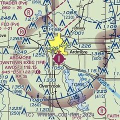
|
| Airport distance calculator |
|---|
|
|
| Sunrise and sunset |
|---|
|
Times for 02-May-2026
| | Local
(UTC-5) | | Zulu
(UTC) |
|---|
| Morning civil twilight | | 06:12 | | 11:12 |
| Sunrise | | 06:39 | | 11:39 |
| Sunset | | 20:12 | | 01:12 |
| Evening civil twilight | | 20:39 | | 01:39 |
|
| Current date and time |
|---|
| Zulu (UTC) | 02-May-2026 07:57:44 |
|---|
| Local (UTC-5) | 02-May-2026 02:57:44 |
|---|
|
| METAR |
|---|
| K1F0 | 020735Z AUTO 00000KT 10SM CLR 08/07 A3010 RMK AO2 T00840073
|
KADM
10nm NE | 020735Z AUTO 00000KT 10SM CLR 09/06 A3010 RMK AO2
|
|
| TAF |
|---|
KDUA
38nm E | 020520Z 0206/0306 VRB03KT P6SM SCT100 BKN250 FM030000 15006KT P6SM FEW250
|
|
| NOTAMs |
|---|
NOTAMs are issued by the DoD/FAA and will open in a separate window not controlled by AirNav.
|
|

