FAA INFORMATION EFFECTIVE 19 FEBRUARY 2026
Location
| FAA Identifier: | 2R9 |
| Lat/Long: | 28-49-29.9485N 097-51-56.0460W
28-49.499142N 097-51.934100W
28.8249857,-97.8655683
(estimated) |
| Elevation: | 288.7 ft. / 88.0 m (surveyed) |
| Variation: | 05E (2010) |
| From city: | 1 mile NW of KENEDY, TX |
| Time zone: | UTC -6 (UTC -5 during Daylight Saving Time) |
| Zip code: | 78119 |
Airport Operations
| Airport use: | Open to the public |
| Control tower: | no |
| ARTCC: | HOUSTON CENTER |
| FSS: | SAN ANGELO FLIGHT SERVICE STATION |
| NOTAMs facility: | SJT (NOTAM-D service available) |
| Attendance: | MON-FRI DAYLIGHT HOURS |
| Wind indicator: | lighted |
| Segmented circle: | yes |
| Lights: | MIRL RWY 16/34 & TWY LGTS PRESET LOW INTST; TO INCR INTST ACTVT - CTAF. |
| Beacon: | white-green (lighted land airport)
Operates sunset to sunrise. |
Airport Communications
| CTAF/UNICOM: | 123.0 |
| WX AWOS-3PT: | 118.45 (830-583-8080) |
| WX ASOS at NGT (18 nm SE): | 353.675 |
- APCH/DEP CTL SVC PRVDD BY HOUSTON ARTCC (ZHU) ON FREQS 134.6/322.5 (THREE RIVERS RCAG).
Nearby radio navigation aids
| VOR radial/distance | | VOR name | | Freq | | Var |
|---|
| SSFr128/(39.9) | | STINSON VOR | | 108.40 | | 03E |
Airport Services
| Fuel available: | 100LL JET-A |
| Parking: | tiedowns |
| Airframe service: | MAJOR |
| Powerplant service: | MAJOR |
Runway Information
Runway 16/34
| Dimensions: | 3218 x 60 ft. / 981 x 18 m |
| Surface: | asphalt, in excellent condition |
| Weight bearing capacity: | |
| Runway edge lights: | medium intensity |
| RUNWAY 16 | | RUNWAY 34 |
| Latitude: | 28-49.760033N | | 28-49.238250N |
| Longitude: | 097-51.990067W | | 097-51.878133W |
| Elevation: | 288.7 ft. | | 272.2 ft. |
| Traffic pattern: | right | | left |
| Runway heading: | 164 magnetic, 169 true | | 344 magnetic, 349 true |
| Markings: | nonprecision, in good condition | | nonprecision, in good condition |
| Visual slope indicator: | 2-light PAPI on left (3.00 degrees glide path) | | 2-light PAPI on left (3.60 degrees glide path)
RSTRD 7 DEGS LEFT DUE TO OBSTS. |
| Runway end identifier lights: | yes | | |
| Touchdown point: | yes, no lights | | yes, no lights |
| Obstructions: | 8 ft. fence, 201 ft. from runway, 204 ft. right of centerline
8 FT FENCE, 30-199 FT DSTC, 202 FT R. | | 16 ft. trees, 201 ft. from runway, 250 ft. left and right of centerline
8FT FENCE 0-199 DSTC, 34 FT TREES, 0-199 FT DSTC, 120-250 FT L. |
Airport Ownership and Management from official FAA records
| Ownership: | Publicly-owned |
| Owner: | CITY OF KENEDY
303 W.MAIN
KENEDY, TX 78119
Phone 830-583-2230 |
| Manager: | RON HYDE
356 AIRPORT RD, P.O. BOX 569
KENEDY, TX 78119
Phone 830-583-5930 |
Additional Remarks
| - | DEER ON & INVOF ARPT. |
| - | ACFT AIRFRAME & POWER PLANT REPAIRS ON CALL 830-299-2295. |
| - | FOR CD CTC HOUSTON ARTCC AT 281-230-5622. |
Instrument Procedures
NOTE: All procedures below are presented as PDF files. If you need a reader for these files, you should download the free Adobe Reader.NOT FOR NAVIGATION. Please procure official charts for flight.
FAA instrument procedures published for use from 19 February 2026 at 0901Z to 19 March 2026 at 0900Z.
IAPs - Instrument Approach Procedures |
|---|
| RNAV (GPS) RWY 16 | |
download (177KB) |
| RNAV (GPS) RWY 34 | |
download (175KB) |
| NOTE: Special Alternate Minimums apply | |
download (139KB) |
| NOTE: Special Take-Off Minimums/Departure Procedures apply | |
download (213KB) |
Other nearby airports with instrument procedures:
KNGT - Goliad Naval Outlying Field (18 nm SE)
KBEA - Beeville Municipal Airport (28 nm S)
TX2 - Chase Field Industrial Airport (30 nm S)
8T6 - Live Oak County Airport (31 nm SW)
KPEZ - Pleasanton Municipal Airport (35 nm W)
|
|

Road maps at:
MapQuest
Bing
Google
| Aerial photo |
|---|
WARNING: Photo may not be current or correct
 Photo by Glenn Maleske
Taken late January 2010
Photo by Glenn Maleske
Taken late January 2010
Do you have a better or more recent aerial photo of Kenedy Regional Airport that you would like to share? If so, please send us your photo.
|
| Sectional chart |
|---|
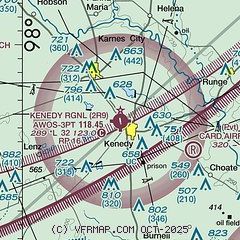
|
| Airport distance calculator |
|---|
|
|
| Sunrise and sunset |
|---|
|
Times for 02-Mar-2026
| | Local
(UTC-6) | | Zulu
(UTC) |
|---|
| Morning civil twilight | | 06:33 | | 12:33 |
| Sunrise | | 06:57 | | 12:57 |
| Sunset | | 18:31 | | 00:31 |
| Evening civil twilight | | 18:55 | | 00:55 |
|
| Current date and time |
|---|
| Zulu (UTC) | 02-Mar-2026 06:45:20 |
|---|
| Local (UTC-6) | 02-Mar-2026 00:45:20 |
|---|
|
| METAR |
|---|
| K2R9 | 020635Z AUTO 13004KT 10SM SCT013 OVC025 20/18 A3004 RMK AO2
|
|
| TAF |
|---|
KSSF
44nm NW | 020524Z 0206/0306 14009KT P6SM OVC015 FM021700 14011KT P6SM FEW022 FM030500 14008KT P6SM BKN015
|
KRND
47nm NW | 012100Z 0121/0303 15010G22KT 9999 FEW050 SCT200 QNH2992INS BECMG 0205/0206 15010KT 9999 BKN015 QNH3002INS BECMG 0210/0211 15007KT 9999 BKN008 OVC015 QNH3004INS BECMG 0215/0216 16010G15KT 9999 BKN011 BKN018 BKN028 QNH3007INS BECMG 0217/0218 17012G18KT 9999 SCT040 SCT200 QNH2996INS TX28/0122Z TN17/0213Z LAST NO AMDS AFT 0200 NEXT 0211
|
KVCT
49nm E | 020531Z 0206/0306 13006KT P6SM SCT010 OVC022 FM020900 13006KT 5SM BR OVC009 TEMPO 0211/0215 1/2SM FG VV003 FM021600 14012KT P6SM SCT035 FM030200 12007KT P6SM FEW020
|
KSKF
49nm NW | 020200Z 0202/0308 16012G18KT 9999 SKC QNH2995INS BECMG 0205/0206 15009KT 9999 BKN018 QNH2998INS BECMG 0208/0209 15009KT 9999 OVC011 QNH2999INS TEMPO 0209/0212 OVC008 BECMG 0214/0215 16009KT 9999 BKN020 OVC027 QNH3006INS BECMG 0216/0217 16010G15KT 9999 BKN027 BKN035 QNH2999INS BECMG 0218/0219 16012G20KT 9999 SCT045 QNH2991INS BECMG 0300/0301 15010KT 9999 FEW050 QNH2995INS BECMG 0307/0308 15008KT 9999 BKN017 QNH2999INS TX31/0222Z TN20/0210Z
|
|
| NOTAMs |
|---|
NOTAMs are issued by the DoD/FAA and will open in a separate window not controlled by AirNav.
|
|

