FAA INFORMATION EFFECTIVE 30 OCTOBER 2025
Location
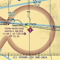
| FAA Identifier: | 2V6 |
| Lat/Long: | 40-06-20.5577N 102-42-51.9757W
40-06.342628N 102-42.866262W
40.1057105,-102.7144377
(estimated) |
| Elevation: | 4137.7 ft. / 1261.2 m (surveyed) |
| Variation: | 07E (2020) |
| From city: | 1 mile SE of YUMA, CO |
| Time zone: | UTC -6 (UTC -7 during Standard Time) |
| Zip code: | 80759 |
Airport Operations
| Airport use: | Open to the public |
| Activation date: | 03/1945 |
| Control tower: | no |
| ARTCC: | DENVER CENTER |
| FSS: | DENVER FLIGHT SERVICE STATION |
| NOTAMs facility: | DEN (NOTAM-D service available) |
| Attendance: | MON-SAT DAYLIGHT HOURS |
| Wind indicator: | lighted |
| Segmented circle: | yes |
| Lights: | MIRL RWY 16/34 PRESET MED INTS DUSK-DAWN. ACTVT REIL RWY 16/34 - CTAF. PCL NOT AVBL FOR PAPI SYS. |
| Beacon: | white-green (lighted land airport)
Operates sunset to sunrise. |
Airport Communications
| CTAF/UNICOM: | 122.8 |
| WX AWOS-3: | 135.375 (970-848-3007) |
- APCH/DEP CTL SVC PRVDD BY DENVER ARTCC (ZDV) ON 133.95/317.55 BRUSH/A/ RCAG.
Nearby radio navigation aids
| VOR radial/distance | | VOR name | | Freq | | Var |
|---|
| AKOr085/21.6 | | AKRON VOR/DME | | 114.40 | | 13E |
| TXCr031/33.6 | | THURMAN VORTAC | | 112.90 | | 12E |
Airport Services
| Fuel available: | 100LL J
100LL:SELF SERVE
J:SELF SERVE |
| Parking: | hangars and tiedowns |
| Airframe service: | NONE |
| Powerplant service: | NONE |
| Bottled oxygen: | NONE |
| Bulk oxygen: | NONE |
Runway Information
Runway 16/34
| Dimensions: | 4201 x 75 ft. / 1280 x 23 m |
| Surface: | asphalt, in excellent condition |
| Weight bearing capacity: | |
| Runway edge lights: | medium intensity |
| RUNWAY 16 | | RUNWAY 34 |
| Latitude: | 40-06.608107N | | 40-05.920348N |
| Longitude: | 102-42.915350W | | 102-42.819148W |
| Elevation: | 4131.5 ft. | | 4133.2 ft. |
| Traffic pattern: | left | | right |
| Runway heading: | 166 magnetic, 173 true | | 346 magnetic, 353 true |
| Markings: | precision, in good condition | | precision, in good condition |
| Visual slope indicator: | 2-light PAPI on left (3.00 degrees glide path)
PAPI UNUSBL BYD 8 DEG RIGHT OF CNTRLN. | | 2-light PAPI on left (3.00 degrees glide path) |
| Runway end identifier lights: | yes | | yes |
| Touchdown point: | yes, no lights | | yes, no lights |
| Obstructions: | 15 ft. tree, 740 ft. from runway, 85 ft. left of centerline, 36:1 slope to clear
INTERMITTENT +12 FT IRRIGATION PIVOT | | 13 ft. other, 632 ft. from runway, 124 ft. left of centerline, 33:1 slope to clear |
Runway 12/30
| Dimensions: | 3277 x 60 ft. / 999 x 18 m
RWY 12/30 CNTR 650 FT ASPH, RMNDR GRVL. |
| Surface: | asphalt/gravel, in good condition |
| RUNWAY 12 | | RUNWAY 30 |
| Latitude: | 40-06.626893N | | 40-06.259392N |
| Longitude: | 102-43.122282W | | 102-42.607710W |
| Elevation: | 4137.7 ft. | | 4117.9 ft. |
| Traffic pattern: | right | | left |
| Runway heading: | 126 magnetic, 133 true | | 306 magnetic, 313 true |
| Markings: | basic, in good condition | | basic, in good condition |
| Touchdown point: | yes, no lights | | yes, no lights |
| Obstructions: | 18 ft. road, 78 ft. from runway, 16 ft. right of centerline, 4:1 slope to clear | | 13 ft. road, 194 ft. from runway, 14:1 slope to clear |
Airport Ownership and Management from official FAA records
| Ownership: | Publicly-owned |
| Owner: | CITY OF YUMA
910 S MAIN ST
YUMA, CO 80759
Phone 970-848-3878 |
| Manager: | ROBERT MOORE
321 S. MAIN ST.
YUMA, CO 80759
Phone 970-848-3878
CITY MANAGER. |
Additional Remarks
| - | TWYS MKD WITH BLUE & YELLOW REFLECTORS. |
| - | RWY 12/30 SOFT WHEN WET. |
| - | RWY 30 HAS 2 FT DITCH AT THLD 0B; 4 FT FENCE 50 FT FM THLD 0B. |
| - | BE ALERT, INTENSIVE USAF STUDENT TRNG INVOF COLORADO SPRINGS & PUEBLO. |
| - | FOR CD CTC DENVER ARTCC AT 303-651-4257. |
Instrument Procedures
NOTE: All procedures below are presented as PDF files. If you need a reader for these files, you should download the free Adobe Reader.NOT FOR NAVIGATION. Please procure official charts for flight.
FAA instrument procedures published for use from 30 October 2025 at 0901Z to 27 November 2025 at 0900Z.
IAPs - Instrument Approach Procedures |
|---|
| RNAV (GPS) RWY 16 | |
download (201KB) |
| RNAV (GPS) RWY 34 | |
download (207KB) |
| NOTE: Special Take-Off Minimums/Departure Procedures apply | |
download (156KB) |
Other nearby airports with instrument procedures:
2V5 - Wray Municipal Airport (22 nm E)
KAKO - Colorado Plains Regional Airport (24 nm W)
KHEQ - Holyoke Airport (34 nm NE)
KSTK - Sterling Municipal Airport (40 nm NW)
KSYF - Cheyenne County Municipal Airport (47 nm SE)
|
|

Road maps at:
MapQuest
Bing
Google
| Aerial photo |
|---|
WARNING: Photo may not be current or correct
 Photo by David Newcomer
Photo taken 31-Mar-2012
from 3,000' AGL looking north.
Photo by David Newcomer
Photo taken 31-Mar-2012
from 3,000' AGL looking north.
Do you have a better or more recent aerial photo of Yuma Municipal Airport that you would like to share? If so, please send us your photo.
|
| Sectional chart |
|---|
|
| Airport distance calculator |
|---|
|
|
| Sunrise and sunset |
|---|
|
Times for 01-Nov-2025
| | Local
(UTC-6) | | Zulu
(UTC) |
|---|
| Morning civil twilight | | 06:53 | | 12:53 |
| Sunrise | | 07:21 | | 13:21 |
| Sunset | | 17:48 | | 23:48 |
| Evening civil twilight | | 18:16 | | 00:16 |
|
| Current date and time |
|---|
| Zulu (UTC) | 02-Nov-2025 05:57:29 |
|---|
| Local (UTC-6) | 01-Nov-2025 23:57:29 |
|---|
|
| METAR |
|---|
| K2V6 | 020534Z AUTO 23009KT 10SM CLR 02/M06 A3008 RMK AO2
|
|
| NOTAMs |
|---|
NOTAMs are issued by the DoD/FAA and will open in a separate window not controlled by AirNav.
|
|


