FAA INFORMATION EFFECTIVE 11 JUNE 2026
Location
| FAA Identifier: | 3E0 |
| Lat/Long: | 35-42-50.1560N 100-36-11.4920W
35-42.835933N 100-36.191533W
35.7139322,-100.6031922
(estimated) |
| Elevation: | 2720 ft. / 829 m (estimated) |
| Variation: | 08E (1985) |
| From city: | 3 miles NE of MIAMI, TX |
| Time zone: | UTC -5 (UTC -6 during Standard Time) |
| Zip code: | 79059 |
Airport Operations
| Airport use: | Open to the public |
| Activation date: | 06/1968 |
| Control tower: | no |
| ARTCC: | ALBUQUERQUE CENTER |
| FSS: | FORT WORTH FLIGHT SERVICE STATION |
| NOTAMs facility: | FTW (NOTAM-D service available) |
| Attendance: | UNATNDD |
| Wind indicator: | lighted |
| Segmented circle: | yes |
| Lights: | ACTVT LIRL RWY 02/20 - CTAF. |
Airport Communications
| CTAF: | 122.9 |
| WX AWOS-3PT at HHF (15 nm NE): | 119.025 (806-225-8080) |
Airport Services
| Parking: | tiedowns |
| Airframe service: | NONE |
| Powerplant service: | NONE |
| Bottled oxygen: | NONE |
| Bulk oxygen: | NONE |
Runway Information
Runway 2/20
| Dimensions: | 4060 x 50 ft. / 1237 x 15 m |
| Surface: | asphalt, in good condition |
| Weight bearing capacity: | |
| Runway edge lights: | low intensity |
| RUNWAY 2 | | RUNWAY 20 |
| Traffic pattern: | left | | right |
| Displaced threshold: | no | | 390 ft. |
| Markings: | basic, in good condition | | basic, in good condition |
| Obstructions: | 20 ft. trees, 225 ft. from runway, 100 ft. right of centerline, 1:1 slope to clear
15 FT TREE, 100 FT DSTC.90 FT L. | | 10 ft. hill, 201 ft. from runway, 125 ft. left and right of centerline
8 FT FENCE (4 FT FENCE ON 4 FT GROUND) 0-125 FT DSTC, 66 FT L TO 20 FT R. 10 FT RD, 0 FT DSTC, 100 FT R. |
Airport Ownership and Management from official FAA records
| Ownership: | Publicly-owned |
| Owner: | COUNTY OF ROBERTS
300 COMMERCIAL ST, P.O. BOX 478
MIAMI, TX 79059
Phone 806-868-2341 |
| Manager: | MITCHEL LOCKE
300 COMMERCIAL ST, P.O. BOX 478
MIAMI, TX 79059
Phone 806-868-3721
COUNTY JUDGE/ARPT MGR. |
Additional Remarks
| - | FOR CD CTC ALBUQUERQUE ARTCC AT 505-856-4861. |
| - | RWY 20, 3 RED LGTS OUTBOARD EACH SIDE OF RWY EDGE, 188 FT FM N END OF RWY. |
| - | RWY HAS 25 FT DROP OFF AT S END. |
Instrument Procedures
There are no published instrument procedures at 3E0.
Some nearby airports with instrument procedures:
KHHF - Hemphill County Airport (15 nm NE)
KPPA - Perry Lefors Field Airport (20 nm W)
T59 - Wheeler Municipal Airport (25 nm SE)
1X1 - Higgins/Lipscomb County Airport (37 nm NE)
KBGD - Hutchinson County Airport (39 nm W)
|
|

Road maps at:
MapQuest
Bing
Google
| Aerial photo |
|---|
WARNING: Photo may not be current or correct
 Photo by Charles Robertson
Photo taken 30-May-2009
Photo by Charles Robertson
Photo taken 30-May-2009
Do you have a better or more recent aerial photo of Miami-Roberts County Airport that you would like to share? If so, please send us your photo.
|
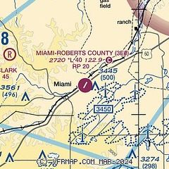
| Sectional chart |
|---|
|
| Airport distance calculator |
|---|
|
|
| Sunrise and sunset |
|---|
|
Times for 21-Jun-2026
| | Local
(UTC-5) | | Zulu
(UTC) |
|---|
| Morning civil twilight | | 05:58 | | 10:58 |
| Sunrise | | 06:28 | | 11:28 |
| Sunset | | 21:01 | | 02:01 |
| Evening civil twilight | | 21:31 | | 02:31 |
|
| Current date and time |
|---|
| Zulu (UTC) | 21-Jun-2026 19:02:37 |
|---|
| Local (UTC-5) | 21-Jun-2026 14:02:37 |
|---|
|
| METAR |
|---|
KHHF
15nm NE | 211855Z AUTO 03003KT 10SM CLR 34/16 A2971 RMK AO2
|
KPPA
21nm SW | 211830Z AUTO 36007KT 330V030 10SM CLR 32/18 A2980 RMK AO2 T03150184
|
|
| NOTAMs |
|---|
NOTAMs are issued by the DoD/FAA and will open in a separate window not controlled by AirNav.
|
|

