FAA INFORMATION EFFECTIVE 09 JULY 2026
Location
| FAA Identifier: | 3I2 |
| Lat/Long: | 38-54-52.6850N 082-05-54.8840W
38-54.878083N 082-05.914733W
38.9146347,-82.0985789
(estimated) |
| Elevation: | 643.4 ft. / 196.1 m (surveyed) |
| Variation: | 07W (2000) |
| From city: | 4 miles NE of POINT PLEASANT, WV |
| Time zone: | UTC -4 (UTC -5 during Standard Time) |
| Zip code: | 25550 |
Airport Operations
| Airport use: | Open to the public |
| Control tower: | no |
| ARTCC: | INDIANAPOLIS CENTER |
| FSS: | ELKINS FLIGHT SERVICE STATION [703-724-4288] |
| NOTAMs facility: | EKN (NOTAM-D service available) |
| Attendance: | MON-FRI 1000-1400 |
| Wind indicator: | lighted |
| Segmented circle: | yes |
| Lights: | ACTVT REIL RWY 07 & 25; PAPI RWY 07 & 25; MIRL RWY 07/25 - CTAF. |
| Beacon: | white-green (lighted land airport)
Operates sunset to sunrise. |
Airport Communications
| CTAF/UNICOM: | 122.8 |
| WX AWOS-3: | 119.675 (304-675-4618) |
| HUNTINGTON APPROACH: | 128.4 |
| HUNTINGTON DEPARTURE: | 128.4 |
| WX AWOS-3PT at GAS (6 nm SW): | 119.925 (740-446-2149) |
| WX AWOS-2 at I18 (13 nm E): | 121.3 (304-273-3424) |
| WX AWOS-3 at UNI (19 nm N): | 128.325 (740-597-2687) |
Nearby radio navigation aids
| VOR radial/distance | | VOR name | | Freq | | Var |
|---|
| HVQr339/37.2 | | CHARLESTON VOR/DME | | 117.40 | | 03W |
| NDB name | | Hdg/Dist | | Freq | | Var | | ID |
|---|
| UNIVERSITY | | 182/20.6 | | 250 | | 06W | | UGS | ..- --. ... |
Airport Services
| Bottled oxygen: | NONE |
| Bulk oxygen: | NONE |
Runway Information
Runway 7/25
| Dimensions: | 4000 x 75 ft. / 1219 x 23 m |
| Surface: | asphalt, in fair condition |
| Weight bearing capacity: | |
| Runway edge lights: | medium intensity |
| RUNWAY 7 | | RUNWAY 25 |
| Latitude: | 38-54.738182N | | 38-55.017960N |
| Longitude: | 082-06.296492W | | 082-05.532967W |
| Elevation: | 639.0 ft. | | 625.4 ft. |
| Traffic pattern: | left | | left |
| Runway heading: | 072 magnetic, 065 true | | 252 magnetic, 245 true |
| Markings: | nonprecision, in fair condition | | nonprecision, in fair condition |
| Visual slope indicator: | 2-light PAPI on left (3.00 degrees glide path) | | 2-light PAPI on left (3.00 degrees glide path) |
| Runway end identifier lights: | yes | | yes |
| Touchdown point: | yes, no lights | | yes, no lights |
| Obstructions: | 20 ft. trees, 420 ft. from runway, 20 ft. right of centerline, 11:1 slope to clear
30 FT TREES, 0-199 DSTC, 75 FT R. | | 35 ft. trees, 300 ft. from runway, 140 ft. left and right of centerline, 2:1 slope to clear |
Airport Ownership and Management from official FAA records
| Ownership: | Publicly-owned |
| Owner: | MASON CO COMISSION
COURT HOUSE, 200 6TH ST,
POINT PLEASANT, WV 25550
Phone 304-675-1110 |
| Manager: | TRENT AND PAIGE ROUSH
1518 AIRPORT RD
POINT PLEASANT, WV 25550
Phone 304-674-5075 |
Additional Remarks
| - | DEER ON & INVOF ARPT. |
| - | COLD TEMPERATURE AIRPORT. ALTITUDE CORRECTION REQUIRED AT OR BELOW -16C. |
| - | FOR CD CTC HUNTINGTON ATCT AT 304-453-2490. |
| - | SEVERAL POWER PLANT STACKS IN VICINITY OF ARPT WEST & NORTH. |
| - | RWY 25, 35 FT DROP-OFF, 100 FT FM RWY END. |
| - | STEAM FROM COOLING TOWERS NW OCCASIONALLY OBSCURES OBSTN LGTS ON TOWER NORTH. |
| - | RWY 07 HAS 3 FT DITCH 80 FT L & R OF CNTRLN FIRST 1000 FT. |
| - | 6-8 FT BRUSH PARALLEL TO RWY 25, 95 FT FM CENTERLINE. |
Instrument Procedures
There are no published instrument procedures at 3I2.
Some nearby airports with instrument procedures:
KGAS - Gallia-Meigs Regional Airport (6 nm SW)
I18 - Jackson County Airport (13 nm E)
KUNI - Ohio University Airport (19 nm N)
KJRO - James A Rhodes Airport (23 nm W)
12V - Ona Airpark (29 nm S)
|
|

Road maps at:
MapQuest
Bing
Google
| Aerial photo |
|---|
WARNING: Photo may not be current or correct

Do you have a better or more recent aerial photo of Mason County Airport that you would like to share? If so, please send us your photo.
|
| Sectional chart |
|---|
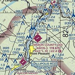
|
| Airport distance calculator |
|---|
|
|
| Sunrise and sunset |
|---|
|
Times for 14-Jul-2026
| | Local
(UTC-4) | | Zulu
(UTC) |
|---|
| Morning civil twilight | | 05:44 | | 09:44 |
| Sunrise | | 06:16 | | 10:16 |
| Sunset | | 20:53 | | 00:53 |
| Evening civil twilight | | 21:24 | | 01:24 |
|
| Current date and time |
|---|
| Zulu (UTC) | 14-Jul-2026 08:13:17 |
|---|
| Local (UTC-4) | 14-Jul-2026 04:13:17 |
|---|
|
| METAR |
|---|
KUNI
19nm N | 140755Z AUTO 00000KT 10SM SCT001 20/20 A3018 RMK AO2 T02030203
|
|
| TAF |
|---|
KHTS
39nm SW | 140520Z 1406/1506 00000KT P6SM SKC FM141000 00000KT 5SM BR FEW001 FM141200 07004KT P6SM FEW250 FM141800 07004KT P6SM SCT050
|
KCRW
40nm SE | 140627Z 1406/1506 00000KT 1/4SM FG BKN002 FM141100 00000KT 1SM BR BKN001 FM141200 00000KT P6SM SCT015 FM141500 00000KT P6SM FEW015 FM141800 05002KT P6SM FEW040
|
KPKB
41nm NE | 140520Z 1406/1506 00000KT P6SM SKC FM140700 00000KT 5SM BR SCT001 FM141000 00000KT 1/4SM FG OVC001 FM141200 00000KT 3SM BR BKN002 FM141300 00000KT P6SM FEW030 FM141800 VRB02KT P6SM FEW040
|
|
| NOTAMs |
|---|
NOTAMs are issued by the DoD/FAA and will open in a separate window not controlled by AirNav.
|
|

