FAA INFORMATION EFFECTIVE 30 OCTOBER 2025
Location
| FAA Identifier: | 4R5 |
| Lat/Long: | 46-47-19.2000N 090-45-31.4000W
46-47.320000N 090-45.523333W
46.7886667,-90.7587222
(estimated) |
| Elevation: | 648.6 ft. / 197.7 m (surveyed) |
| Variation: | 00E (1985) |
| From city: | 2 miles NE of LA POINTE, WI |
| Time zone: | UTC -6 (UTC -5 during Daylight Saving Time) |
| Zip code: | 54850 |
Airport Operations
| Airport use: | Open to the public |
| Activation date: | 08/1949 |
| Control tower: | no |
| ARTCC: | MINNEAPOLIS CENTER |
| FSS: | GREEN BAY FLIGHT SERVICE STATION |
| NOTAMs facility: | GRB (NOTAM-D service available) |
| Attendance: | UNATNDD |
| Wind indicator: | lighted |
| Segmented circle: | no |
| Lights: | ACTVT REIL RWY 04; PAPI RWY 04 & 22 - CTAF. MIRL RWY 04/22 PRESET TO LOW SS-SR, TO INCR INTST & ACTVT - CTAF. |
| Beacon: | white-green (lighted land airport)
Operates sunset to sunrise. |
Airport Communications
| CTAF: | 122.9 |
| WX AWOS-3PT: | 119.375 (715-747-5519) |
| WX ASOS at ASX (16 nm SW): | 126.775 (715-682-5541) |
- APCH/DEP SVC PRVDD BY MINNEANAPOLIS ARTCC (ZMP) ON FREQ 133.55 (IRONWOOD RCAG).
Nearby radio navigation aids
| VOR radial/distance | | VOR name | | Freq | | Var |
|---|
| IWDr300/30.3 | | IRONWOOD VOR/DME | | 108.80 | | 01E |
Airport Services
| Parking: | tiedowns |
| Airframe service: | NONE |
| Powerplant service: | NONE |
| Bottled oxygen: | NONE |
| Bulk oxygen: | NONE |
Runway Information
Runway 4/22
| Dimensions: | 3000 x 75 ft. / 914 x 23 m |
| Surface: | asphalt, in excellent condition |
| Weight bearing capacity: | |
| Runway edge lights: | medium intensity |
| RUNWAY 4 | | RUNWAY 22 |
| Latitude: | 46-47.131000N | | 46-47.509000N |
| Longitude: | 090-45.754500W | | 090-45.292500W |
| Elevation: | 624.3 ft. | | 648.6 ft. |
| Traffic pattern: | left | | left |
| Runway heading: | 040 | | 220 |
| Markings: | nonprecision, in good condition | | nonprecision, in good condition |
| Visual slope indicator: | 2-light PAPI on left (3.75 degrees glide path) | | 2-light PAPI on left (3.75 degrees glide path) |
| Runway end identifier lights: | yes | | no |
| Touchdown point: | yes, no lights | | yes, no lights |
| Obstructions: | 75 ft. trees, 750 ft. from runway, 275 ft. left of centerline, 7:1 slope to clear | | 61 ft. trees, 430 ft. from runway, 245 ft. right of centerline, 3:1 slope to clear
40 FT TREES 190 FT FM RWY END, 230 FT L. |
Airport Ownership and Management from official FAA records
| Ownership: | Publicly-owned |
| Owner: | TOWN OF LAPOINTE
PO BOX 270
LA POINTE, WI 54850
Phone 715-747-6914 |
| Manager: | PAUL WILHARM
BOX 270
LA POINTE, WI 54850
Phone (612) 685-0445 |
Additional Remarks
| - | DEER & WATERFOWL ON & INVOF ARPT. |
| - | FOR CD CTC MINNEAPOLIS ARTCC AT 651-463-5588. |
Instrument Procedures
NOTE: All procedures below are presented as PDF files. If you need a reader for these files, you should download the free Adobe Reader.NOT FOR NAVIGATION. Please procure official charts for flight.
FAA instrument procedures published for use from 30 October 2025 at 0901Z to 27 November 2025 at 0900Z.
IAPs - Instrument Approach Procedures |
|---|
| RNAV (GPS) RWY 04 | |
download (192KB) |
| RNAV (GPS) RWY 22 | |
download (185KB) |
| NOTE: Special Alternate Minimums apply | |
download (140KB) |
| NOTE: Special Take-Off Minimums/Departure Procedures apply | |
download (201KB) |
Other nearby airports with instrument procedures:
KASX - John F Kennedy Memorial Airport (16 nm SW)
KIWD - Gogebic/Iron County Airport (30 nm SE)
3CU - Cable Union Airport (41 nm SW)
KTWM - Richard B Helgeson Airport (43 nm W)
KPKF - Park Falls Municipal Airport (52 nm S)
|
|

Road maps at:
MapQuest
Bing
Google
| Aerial photo |
|---|
WARNING: Photo may not be current or correct
 Photo by Julie Kellogg
Photo taken 05-Jun-2007
looking north
Photo by Julie Kellogg
Photo taken 05-Jun-2007
looking north
Do you have a better or more recent aerial photo of Major Gilbert Field Airport that you would like to share? If so, please send us your photo.
|
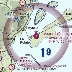
| Sectional chart |
|---|
|
| Airport distance calculator |
|---|
|
|
| Sunrise and sunset |
|---|
|
Times for 23-Nov-2025
| | Local
(UTC-6) | | Zulu
(UTC) |
|---|
| Morning civil twilight | | 06:44 | | 12:44 |
| Sunrise | | 07:18 | | 13:18 |
| Sunset | | 16:21 | | 22:21 |
| Evening civil twilight | | 16:55 | | 22:55 |
|
| Current date and time |
|---|
| Zulu (UTC) | 23-Nov-2025 11:10:34 |
|---|
| Local (UTC-6) | 23-Nov-2025 05:10:34 |
|---|
|
| METAR |
|---|
| K4R5 | 231055Z AUTO 23004KT 10SM CLR 02/M02 A2998 RMK AO2 T00151017
|
KASX
16nm SW | 231053Z AUTO 23005KT 10SM CLR 01/M03 A3000 RMK AO2 SLP167 T00061028
|
|
| TAF |
|---|
KIWD
31nm SE | 230520Z 2306/2406 28011G21KT P6SM SCT030 FM231100 27008KT P6SM SKC FM240000 20005KT P6SM SCT090
|
|
| NOTAMs |
|---|
NOTAMs are issued by the DoD/FAA and will open in a separate window not controlled by AirNav.
|
|

