FAA INFORMATION EFFECTIVE 12 JUNE 2025
Location
| FAA Identifier: | 56D |
| Lat/Long: | 40-53-00.1269N 083-18-52.3136W
40-53.002115N 083-18.871893W
40.8833686,-83.3145316
(estimated) |
| Elevation: | 829.8 ft. / 253 m (estimated) |
| Variation: | 05W (1985) |
| From city: | 4 miles NW of UPPER SANDUSKY, OH |
| Time zone: | UTC -4 (UTC -5 during Standard Time) |
| Zip code: | 43351 |
Airport Operations
| Airport use: | Open to the public |
| Activation date: | 09/1955 |
| Control tower: | no |
| ARTCC: | CLEVELAND CENTER |
| FSS: | CLEVELAND FLIGHT SERVICE STATION |
| NOTAMs facility: | CLE (NOTAM-D service available) |
| Attendance: | UNATNDD |
| Wind indicator: | lighted |
| Segmented circle: | no |
| Lights: | ACTVT LIRL RWY 18/36 - CTAF. |
| Beacon: | white-green (lighted land airport)
ACTVT ABN - CTAF. |
Airport Communications
| CTAF/UNICOM: | 123.05 |
| CLEVELAND APPROACH: | 128.35 |
| CLEVELAND DEPARTURE: | 128.35 |
| WX AWOS-3 at 16G (13 nm N): | 127.175 (419-443-1043) |
| WX AWOS-3 at 17G (17 nm E): | 126.625 (419-562-0279) |
| WX ASOS at FDY (18 nm NW): | 132.85 (419-427-8524) |
| WX AWOS-3 at FZI (19 nm N): | 124.625 (419-436-0053) |
| WX ASOS at MNN (20 nm SE): | 119.975 (740-223-7502) |
- APCH/DEP SVC PRVDD BY CLEVELAND APCH (CLE) 0600-0100. APCH/DEP SVC PRVDD BY CLEVELAND ARTCC (ZOB) ON FREQS 135.1/291.725 (FINDLAY RCAG) 0100-0600.
Nearby radio navigation aids
| VOR radial/distance | | VOR name | | Freq | | Var |
|---|
| BUDr330/(19.6) | | BUCKEYE VOR | | 109.80 | | 05W |
| FBCr104/20.5 | | FLAG CITY VORTAC | | 108.20 | | 02W |
| MFDr275/32.8 | | MANSFIELD VORTAC | | 108.80 | | 03W |
| NDB name | | Hdg/Dist | | Freq | | Var | | ID |
|---|
| TIFFIN | | 205/13.5 | | 269 | | 05W | | TII | - .. .. |
Airport Services
| Parking: | tiedowns |
| Airframe service: | NONE |
| Powerplant service: | NONE |
| Bottled oxygen: | NONE |
| Bulk oxygen: | NONE |
Runway Information
Runway 18/36
| Dimensions: | 3997 x 75 ft. / 1218 x 23 m |
| Surface: | asphalt, in good condition |
| Weight bearing capacity: | |
| Runway edge lights: | low intensity |
| Runway edge markings: | FADED.
NSTD BASIC DUE TO THR MKGS. |
| RUNWAY 18 | | RUNWAY 36 |
| Latitude: | 40-53.331203N | | 40-52.673025N |
| Longitude: | 083-18.869807W | | 083-18.873980W |
| Elevation: | 824.0 ft. | | 828.4 ft. |
| Traffic pattern: | left | | right |
| Runway heading: | 185 magnetic, 180 true | | 005 magnetic, 000 true |
| Markings: | NSTD, in poor condition | | NSTD, in poor condition |
| Runway end identifier lights: | | | no |
| Touchdown point: | yes, no lights | | yes, no lights |
| Obstructions: | 55 ft. tree, 991 ft. from runway, 205 ft. right of centerline, 14:1 slope to clear | | 8 ft. brush, 281 ft. from runway, 117 ft. left of centerline, 10:1 slope to clear
OBST CLNC SLP 0:1 DUE TO +5-10 FT BRUSH, 0-200 FT DIST, 120 FT L; +1-7 FT BRUSH, 0-200 FT DIST, 92 FT R. |
Airport Ownership and Management from official FAA records
| Ownership: | Publicly-owned |
| Owner: | COUNTY AIRPORT AUTHORITY
109 S SANDUSKY AVE
UPPER SANDUSKY, OH 43351 |
| Manager: | MITCHEL GRENWALT
10841 COUNTY HIGHWAY 42
UPPER SANDUSKY, OH 43351-9139
Phone 419-294-8766
OR 419-294-3814. |
Additional Remarks
| A30A-18 | CALM WIND RWY. |
| - | RWY 36 RP DUE TO +205 FT LGTD BLDG WEST OF ARPT. |
| - | DEER, BIRDS, & OTR WILDLIFE ON & INVOF ARPT; BIRD ACT AT LANDFILL 1.5 NM NNW OF ARPT. |
| - | FOR CD CTC CLEVELAND APCH AT 216-352-2323, WHEN APCH CLSD CTC CLEVELAND ARTCC AT 440-774-0222/0490. |
Instrument Procedures
NOTE: All procedures below are presented as PDF files. If you need a reader for these files, you should download the free Adobe Reader.NOT FOR NAVIGATION. Please procure official charts for flight.
FAA instrument procedures published for use from 12 June 2025 at 0901Z to 10 July 2025 at 0900z.
IAPs - Instrument Approach Procedures |
|---|
| VOR-A | |
download (211KB) |
| NOTE: Special Take-Off Minimums/Departure Procedures apply | |
download (164KB) |
Other nearby airports with instrument procedures:
16G - Seneca County Airport (13 nm N)
17G - Port Bucyrus/Crawford County Airport (17 nm E)
KFDY - Findlay Airport (18 nm NW)
KFZI - Donald P Miller Airport (19 nm N)
KMNN - Marion Municipal Airport (20 nm SE)
|
|

Road maps at:
MapQuest
Bing
Google
| Aerial photo |
|---|
WARNING: Photo may not be current or correct

Do you have a better or more recent aerial photo of Wyandot County Airport that you would like to share? If so, please send us your photo.
|
| Sectional chart |
|---|
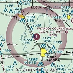
|
| Airport distance calculator |
|---|
|
|
| Sunrise and sunset |
|---|
|
Times for 29-Jun-2025
| | Local
(UTC-4) | | Zulu
(UTC) |
|---|
| Morning civil twilight | | 05:32 | | 09:32 |
| Sunrise | | 06:05 | | 10:05 |
| Sunset | | 21:08 | | 01:08 |
| Evening civil twilight | | 21:42 | | 01:42 |
|
| Current date and time |
|---|
| Zulu (UTC) | 29-Jun-2025 09:36:00 |
|---|
| Local (UTC-4) | 29-Jun-2025 05:36:00 |
|---|
|
| METAR |
|---|
KFDY
18nm NW | 290853Z AUTO 00000KT 10SM CLR 21/18 A3002 RMK AO2 SLP157 T02060178 51004
|
KMNN
20nm SE | 290853Z AUTO 00000KT OVC002 19/19 A3003 RMK AO2 SLP164 T01940194 53001
|
KOWX
32nm W | 290915Z AUTO 32003KT 10SM CLR 18/18 A3005 RMK AO2
|
KAOH
34nm W | 290853Z AUTO 00000KT 10SM CLR 19/18 A3004 RMK AO2 SLP163 T01890178 53001
|
|
| TAF |
|---|
KFDY
18nm NW | 290520Z 2906/3006 00000KT P6SM SKC FM290900 VRB03KT 3SM BR SKC FM291300 25005KT P6SM SCT250
|
|
| NOTAMs |
|---|
NOTAMs are issued by the DoD/FAA and will open in a separate window not controlled by AirNav.
|
|


