FAA INFORMATION EFFECTIVE 30 OCTOBER 2025
Location
| FAA Identifier: | 5D5 |
| Lat/Long: | 45-09-51.6487N 085-34-31.7212W
45-09.860812N 085-34.528687W
45.1643469,-85.5754781
(estimated) |
| Elevation: | 628 ft. / 191.4 m (surveyed) |
| Variation: | 05W (1985) |
| From city: | 3 miles NE of NORTHPORT, MI |
| Time zone: | UTC -5 (UTC -4 during Daylight Saving Time) |
| Zip code: | 49670 |
Airport Operations
| Airport use: | Open to the public |
| Activation date: | 04/1940 |
| Control tower: | no |
| ARTCC: | MINNEAPOLIS CENTER |
| FSS: | LANSING FLIGHT SERVICE STATION |
| NOTAMs facility: | LAN (NOTAM-D service available) |
| Attendance: | UNATNDD |
| Wind indicator: | lighted |
| Segmented circle: | yes |
| Lights: | ACTVT LIRL RWY 09/27 - CTAF. |
Airport Communications
| CTAF: | 122.9 |
| WX AWOS-3P at CVX (15 nm NE): | 120.0 (231-237-9703) |
| WX AWOS-3P at ACB (19 nm SE): | 119.275 (231-533-8941) |
Nearby radio navigation aids
| VOR radial/distance | | VOR name | | Freq | | Var |
|---|
| TVCr360/29.8 | | TRAVERSE CITY VOR/DME | | 114.60 | | 02W |
Airport Services
Runway Information
Runway 9/27
| Dimensions: | 3663 x 120 ft. / 1116 x 37 m |
| Surface: | turf, in good condition
UPSLP FM WEST TO EAST. |
| Runway edge lights: | low intensity |
| Runway edge markings: | 3 FT YELLOW CONES. |
| RUNWAY 9 | | RUNWAY 27 |
| Latitude: | 45-09.760500N | | 45-09.792000N |
| Longitude: | 085-35.067167W | | 085-34.216333W |
| Elevation: | 616.0 ft. | | 623.0 ft. |
| Traffic pattern: | left | | left |
| Runway heading: | 092 magnetic, 087 true | | 272 magnetic, 267 true |
| Displaced threshold: | 266 ft. | | no |
| Obstructions: | 14 ft. road, 35 ft. from runway, 2:1 slope to clear
APCH RATIO 20:1 TO DTHR. | | 60 ft. trees, 1330 ft. from runway, 100 ft. left of centerline, 22:1 slope to clear |
Runway 16/34
| Dimensions: | 2670 x 150 ft. / 814 x 46 m |
| Surface: | turf, in fair condition
UPSLP FM NORTH TO SOUTH. |
| Runway edge markings: | RWY & DTHR MKD WITH 3 FT YELLOW CONES. |
| RUNWAY 16 | | RUNWAY 34 |
| Latitude: | 45-10.184000N | | 45-09.773667N |
| Longitude: | 085-34.485000W | | 085-34.262333W |
| Elevation: | 605.0 ft. | | 625.0 ft. |
| Traffic pattern: | left | | left |
| Runway heading: | 164 magnetic, 159 true | | 344 magnetic, 339 true |
| Displaced threshold: | 770 ft. | | 300 ft. |
| Obstructions: | 27 ft. trees, 122 ft. right of centerline
APCH RATIO 20:1 TO DTHR OVR +48 FT TREE, 960 FT DIST, 125 FT R. | | 10 ft. road, 50 ft. from runway, 5:1 slope to clear
CTLG OBSTN EXCEEDS A 45 DEG SLP. APCH RATIO 18:1 TO DTHR OVR 34 FT TREE, 620 FT DIST; 25:1 OVR 17 FT BLDG, 425 FT DIST, L OF CNTRLN. |
Airport Ownership and Management from official FAA records
| Ownership: | Publicly-owned |
| Owner: | LEELANAU TWP
119 E NAGONABA ST, PO BOX 338
NORTHPORT, MI 49670-0338
Phone 231-386-5282 |
| Manager: | THOMAS M WETHERBEE
PO BOX 338
NORTHPORT, MI 49670-0338
Phone 231-386-9841 |
Additional Remarks
| - | ARPT CLSD NOV-MAR & WHEN SNOW COVD EXC FOR SKI EQUIPPED ACFT. |
| - | DEER, BIRDS, & WILDLIFE ON & INVOF ARPT. |
| - | FOR CD CTC MINNEAPOLIS ARTCC AT 651-463-5588. |
Instrument Procedures
There are no published instrument procedures at 5D5.
Some nearby airports with instrument procedures:
KCVX - Charlevoix Municipal Airport (15 nm NE)
KACB - Antrim County Airport (19 nm SE)
N98 - Boyne City Municipal Airport (25 nm E)
KTVC - Cherry Capital Airport (25 nm S)
KBFA - Boyne Mountain Airport (28 nm E)
|
|

Road maps at:
MapQuest
Bing
Google
| Aerial photo |
|---|
WARNING: Photo may not be current or correct
 Photo by Scott Antilla
Taken in April 2008
Photo by Scott Antilla
Taken in April 2008
Do you have a better or more recent aerial photo of Woolsey Memorial Airport that you would like to share? If so, please send us your photo.
|
| Sectional chart |
|---|
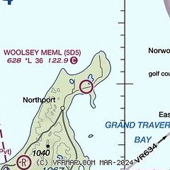
|
| Airport distance calculator |
|---|
|
|
| Sunrise and sunset |
|---|
|
Times for 17-Nov-2025
| | Local
(UTC-5) | | Zulu
(UTC) |
|---|
| Morning civil twilight | | 07:12 | | 12:12 |
| Sunrise | | 07:44 | | 12:44 |
| Sunset | | 17:10 | | 22:10 |
| Evening civil twilight | | 17:42 | | 22:42 |
|
| Current date and time |
|---|
| Zulu (UTC) | 18-Nov-2025 00:37:30 |
|---|
| Local (UTC-5) | 17-Nov-2025 19:37:30 |
|---|
|
| METAR |
|---|
KCVX
15nm NE | 180015Z AUTO 31006KT 10SM BKN034 02/M06 A3008 RMK AO2
|
KACB
19nm SE | 180015Z AUTO 00000KT 10SM OVC038 03/M07 A3009 RMK AO2 T00281071
|
KTVC
26nm S | 172353Z 27006KT 10SM OVC040 02/M06 A3008 RMK AO2 SLP192 T00171061 10050 20017 51011
|
KBFA
28nm E | 180015Z AUTO 32004KT 10SM OVC036 02/M05 A3007 RMK AO2
|
|
| TAF |
|---|
KTVC
26nm S | 171728Z 1718/1818 30012KT P6SM BKN050 FM172100 32003KT P6SM SCT050 BKN250 FM181500 36002KT P6SM FEW250
|
|
| NOTAMs |
|---|
NOTAMs are issued by the DoD/FAA and will open in a separate window not controlled by AirNav.
|
|

