FAA INFORMATION EFFECTIVE 09 JULY 2026
Location
| FAA Identifier: | 5K0 |
| Lat/Long: | 39-44-38.9000N 101-33-23.3000W
39-44.648333N 101-33.388333W
39.7441389,-101.5564722
(estimated) |
| Elevation: | 3489 ft. / 1063 m (estimated) |
| Variation: | 09E (1980) |
| From city: | 1 mile SW of BIRD CITY, KS |
| Time zone: | UTC -5 (UTC -6 during Standard Time) |
| Zip code: | 67731 |
Airport Operations
| Airport use: | Open to the public |
| Activation date: | 11/1986 |
| Control tower: | no |
| ARTCC: | DENVER CENTER |
| FSS: | WICHITA FLIGHT SERVICE STATION |
| NOTAMs facility: | ICT (NOTAM-D service available) |
| Attendance: | APR-SEP DAYLIGHT HOURS, OCT-MAR/UNATNDD/
OCT-MAR CALL 785-734-2631 FOR ARPT CONDS. |
| Wind indicator: | yes |
| Segmented circle: | no |
Airport Communications
| CTAF: | 122.9 |
| WX AWOS-3P at SYF (11 nm W): | 118.925 (785-306-1050) |
Nearby radio navigation aids
| VOR radial/distance | | VOR name | | Freq | | Var |
|---|
| GLDr004/22.3 | | GOODLAND VORTAC | | 115.10 | | 12E |
Airport Services
Runway Information
Runway 8/26
| Dimensions: | 3460 x 70 ft. / 1055 x 21 m |
| Surface: | turf, in good condition
EAST THIRD OF RWY ROUGH. |
| RUNWAY 8 | | RUNWAY 26 |
| Latitude: | 39-44.556980N | | 39-44.554295N |
| Longitude: | 101-33.583395W | | 101-32.844982W |
| Elevation: | 3488.0 ft. | | 3488.0 ft. |
| Traffic pattern: | right | | left |
| Runway heading: | 081 magnetic, 090 true | | 261 magnetic, 270 true |
| Obstructions: | 17 ft. road, 65 ft. right of centerline, 1:1 slope to clear | | 18 ft. road, 65 ft. left of centerline, 1:1 slope to clear |
Runway 17/35
| Dimensions: | 2270 x 75 ft. / 692 x 23 m |
| Surface: | turf, in good condition |
| Runway edge markings: | NORTH END RWY MKD W/ORANGE & WHITE BARRELS. |
| RUNWAY 17 | | RUNWAY 35 |
| Latitude: | 39-44.974807N | | 39-44.600820N |
| Longitude: | 101-33.650673W | | 101-33.653595W |
| Elevation: | 3485.0 ft. | | 3487.0 ft. |
| Traffic pattern: | left | | left |
| Runway heading: | 171 magnetic, 180 true | | 351 magnetic, 000 true |
| Markings: | NSTD | | |
| Obstructions: | 17 ft. road, 77 ft. right of centerline, 1:1 slope to clear | | 17 ft. road, 77 ft. left of centerline, 1:1 slope to clear |
Airport Ownership and Management from official FAA records
| Ownership: | Privately-owned |
| Owner: | CROP PRODUCTION SERVICES, INC
RD M & RD 27, P O BOX 400
BIRD CITY, KS 67731
Phone 785-734-2631 |
| Manager: | ROD YOUNG
122 WEST 6TH
BIRD CITY, KS 67731
Phone 785-734-2631 |
Additional Remarks
| - | FOR CD CTC DENVER ARTCC AT 303-651-4257. |
Instrument Procedures
There are no published instrument procedures at 5K0.
Some nearby airports with instrument procedures:
KSYF - Cheyenne County Municipal Airport (11 nm W)
KGLD - Renner Field/Goodland Municipal Airport (23 nm S)
KADT - Atwood/Rawlins County Airport (24 nm E)
KCBK - Shalz Field Airport (30 nm SE)
KITR - Kit Carson County Airport (45 nm SW)
|
|

Road maps at:
MapQuest
Bing
Google
| Aerial photo |
|---|
WARNING: Photo may not be current or correct
 Photo by Von Rothenberger
Photo taken 23-Jul-2006
from about 5500 ft MSL. The runways are the grass strips along the dirt roads
Photo by Von Rothenberger
Photo taken 23-Jul-2006
from about 5500 ft MSL. The runways are the grass strips along the dirt roads
Do you have a better or more recent aerial photo of Bressler Field Airport that you would like to share? If so, please send us your photo.
|
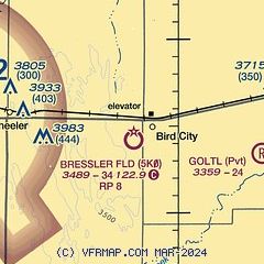
| Sectional chart |
|---|
|
| Airport distance calculator |
|---|
|
|
| Sunrise and sunset |
|---|
|
Times for 16-Jul-2026
| | Local
(UTC-5) | | Zulu
(UTC) |
|---|
| Morning civil twilight | | 06:01 | | 11:01 |
| Sunrise | | 06:33 | | 11:33 |
| Sunset | | 21:12 | | 02:12 |
| Evening civil twilight | | 21:44 | | 02:44 |
|
| Current date and time |
|---|
| Zulu (UTC) | 16-Jul-2026 09:34:42 |
|---|
| Local (UTC-5) | 16-Jul-2026 04:34:42 |
|---|
|
| METAR |
|---|
KSYF
12nm W | 160915Z AUTO 15007KT 10SM CLR 19/15 A3012 RMK AO2
|
KGLD
24nm S | 160853Z AUTO 17009KT 10SM CLR 18/15 A3013 RMK AO2 SLP156 T01830150 56004
|
|
| TAF |
|---|
KGLD
24nm S | 160520Z 1606/1706 16009KT P6SM SKC FM161600 17012G22KT P6SM SCT070
|
|
| NOTAMs |
|---|
NOTAMs are issued by the DoD/FAA and will open in a separate window not controlled by AirNav.
|
|

