FAA INFORMATION EFFECTIVE 09 JULY 2026
Location
| FAA Identifier: | 5K2 |
| Lat/Long: | 38-27-05.2680N 101-45-00.2850W
38-27.087800N 101-45.004750W
38.4514633,-101.7500792
(estimated) |
| Elevation: | 3609.9 ft. / 1100.3 m (surveyed) |
| Variation: | 07E (2015) |
| From city: | 1 mile S of TRIBUNE, KS |
| Time zone: | UTC -6 (UTC -7 during Standard Time) |
| Zip code: | 67879 |
Airport Operations
| Airport use: | Open to the public |
| Activation date: | 05/1950 |
| Control tower: | no |
| ARTCC: | DENVER CENTER |
| FSS: | WICHITA FLIGHT SERVICE STATION |
| NOTAMs facility: | ICT (NOTAM-D service available) |
| Attendance: | UNATNDD |
| Wind indicator: | lighted |
| Segmented circle: | no |
| Lights: | ACTVT MIRLS RWY 17/35, & PAPI RWY 35 - CTAF |
| Beacon: | white-green (lighted land airport)
Operates sunset to sunrise. |
Airport Communications
| CTAF/UNICOM: | 122.8 |
| WX AWOS-3PT: | 119.075 (620-376-2336) |
| WX AWOS-3P at 3K7 (19 nm E): | 118.625 (620-214-5151) |
- APCH CTL SVC PRVDD BY DENVER ARTCC (ZDV) ON FREQS 133.4/377.175 (LA JUNTA RCAG).
Airport Services
| Fuel available: | 100LL
100LL:FOR FUEL CALL 620-376-4299. |
| Parking: | tiedowns |
| Bottled oxygen: | NONE |
| Bulk oxygen: | NONE |
Runway Information
Runway 17/35
| Dimensions: | 5007 x 60 ft. / 1526 x 18 m |
| Surface: | concrete, in excellent condition |
| Weight bearing capacity: | | PCN 11 /R/C/X/U | | Single wheel: | 30.0 |
|
| Runway edge lights: | medium intensity |
| RUNWAY 17 | | RUNWAY 35 |
| Latitude: | 38-27.500167N | | 38-26.675427N |
| Longitude: | 101-45.006457W | | 101-45.003052W |
| Elevation: | 3603.7 ft. | | 3609.9 ft. |
| Traffic pattern: | left | | left |
| Runway heading: | 173 magnetic, 180 true | | 353 magnetic, 360 true |
| Markings: | nonprecision, in good condition | | nonprecision, in good condition |
| Visual slope indicator: | | | 2-light PAPI on left (3.00 degrees glide path) |
| Runway end identifier lights: | no | | no |
| Touchdown point: | yes, no lights | | yes, no lights |
| Obstructions: | 10 ft. road, 522 ft. from runway, 300 ft. both sides of centerline, 32:1 slope to clear | | 55 ft. pline, marked, 2835 ft. from runway, 650 ft. left and right of centerline, 47:1 slope to clear |
Airport Ownership and Management from official FAA records
| Ownership: | Publicly-owned |
| Owner: | CITY AND COUNTY
BOX 277
TRIBUNE, KS 67879-0277
Phone 620-376-4256 |
| Manager: | STEPHANIE REICHERT
508 BROADWAY, PO BOX 577
TRIBUNE, KS 67879
Phone 620-376-4278
620-376-8367 FOR REFUELING. |
Additional Remarks
| - | PUB TELEPHONE AVBL 24 HRS 620-376-2285. |
| - | FOR CD CTC DENVER ARTCC AT 303-651-4257. |
| - | (CONTACT TITLE) ADDRESS QUESTIONS TO: PO BOX 577 508 BROADWAY TRIBUNE, KS 67879 CITYOFTRIBUNE@WBSNET.ORG |
Instrument Procedures
NOTE: All procedures below are presented as PDF files. If you need a reader for these files, you should download the free Adobe Reader.NOT FOR NAVIGATION. Please procure official charts for flight.
FAA instrument procedures published for use from 09 July 2026 at 0901Z to 06 August 2026 at 0900Z.
IAPs - Instrument Approach Procedures |
|---|
| RNAV (GPS) RWY 17 | |
download (181KB) |
| RNAV (GPS) RWY 35 | |
download (219KB) |
| NOTE: Special Take-Off Minimums/Departure Procedures apply | |
download (192KB) |
Other nearby airports with instrument procedures:
3K7 - Mark Hoard Memorial Airport (19 nm E)
3K3 - Syracuse-Hamilton County Municipal Airport (27 nm S)
KTQK - Scott City Municipal Airport (41 nm E)
KLAA - Southeast Colorado Regional Airport (50 nm SW)
KJHN - Stanton County Municipal Airport (52 nm S)
|
|

Road maps at:
MapQuest
Bing
Google
| Aerial photo |
|---|
WARNING: Photo may not be current or correct
 Photo by Von Rothenberger and David Readio
Photo taken 18-Nov-2006
Photo by Von Rothenberger and David Readio
Photo taken 18-Nov-2006
Do you have a better or more recent aerial photo of Tribune Municipal Airport that you would like to share? If so, please send us your photo.
|
| Sectional chart |
|---|
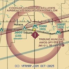
|
| Airport distance calculator |
|---|
|
|
| Sunrise and sunset |
|---|
|
Times for 28-Jul-2026
| | Local
(UTC-6) | | Zulu
(UTC) |
|---|
| Morning civil twilight | | 05:17 | | 11:17 |
| Sunrise | | 05:47 | | 11:47 |
| Sunset | | 20:00 | | 02:00 |
| Evening civil twilight | | 20:30 | | 02:30 |
|
| Current date and time |
|---|
| Zulu (UTC) | 28-Jul-2026 20:29:21 |
|---|
| Local (UTC-6) | 28-Jul-2026 14:29:21 |
|---|
|
| METAR |
|---|
K3K3
27nm S | 282015Z AUTO 05007G17KT 350V070 10SM CLR 37/16 A2994 RMK AO2
|
KTQK
41nm E | 282015Z AUTO 11012KT 10SM CLR 35/19 A2996 RMK AO2 T03480191
|
KLAA
50nm SW | 281953Z AUTO 06006G15KT 10SM CLR 35/18 A2998 RMK AO2 SLP089 T03500178
|
|
| NOTAMs |
|---|
NOTAMs are issued by the DoD/FAA and will open in a separate window not controlled by AirNav.
|
|

