FAA INFORMATION EFFECTIVE 09 JULY 2026
Location
| FAA Identifier: | 5M5 |
| Lat/Long: | 36-20-37.0000N 094-26-41.4000W
36-20.616667N 094-26.690000W
36.3436111,-94.4448333
(estimated) |
| Elevation: | 1177.8 ft. / 359.0 m (surveyed) |
| Variation: | 03E (2005) |
| From city: | 2 miles NE of DECATUR, AR |
| Time zone: | UTC -5 (UTC -6 during Standard Time) |
| Zip code: | 72722 |
Airport Operations
| Airport use: | Open to the public |
| Activation date: | 11/1955 |
| Control tower: | no |
| ARTCC: | MEMPHIS CENTER |
| FSS: | JONESBORO FLIGHT SERVICE STATION |
| NOTAMs facility: | JBR (NOTAM-D service available) |
| Attendance: | UNATNDD |
| Wind indicator: | lighted |
| Segmented circle: | no |
| Lights: | SS-SR |
Airport Communications
| CTAF/UNICOM: | 122.8 |
| RAZORBACK APPROACH: | 121.0 |
| RAZORBACK DEPARTURE: | 121.0 |
| CLEARANCE DELIVERY: | 126.6 |
| WX ASOS at XNA (8 nm SE): | 119.425 (479-370-0218) |
| WX AWOS-3PT at SLG (9 nm S): | 118.375 (479-524-9893) |
| WX AWOS-3PT at VBT (11 nm E): | 134.975 (479-273-9198) |
| WX AWOS-3PT at ROG (16 nm E): | 134.375 (479-631-9196) |
| WX AWOS-3 at ASG (19 nm SE): | 124.675 (479-750-2967) |
- APCH/DEP SVC PRVDD BY MEMPHIS ARTCC ON FREQS 126.1/269.0 (FAYETTEVILLE RCAG) WHEN RAZORBACK APCH CTL CLSD.
Nearby radio navigation aids
| VOR radial/distance | | VOR name | | Freq | | Var |
|---|
| RZCr286/16.7 | | RAZORBACK VORTAC | | 116.40 | | 04E |
| NDB name | | Hdg/Dist | | Freq | | Var | | ID |
|---|
| SILOAM SPRINGS | | 009/9.5 | | 284 | | 04E | | SLG | ... .-.. --. |
Airport Services
| Parking: | hangars and tiedowns |
| Airframe service: | MAJOR |
| Powerplant service: | MAJOR |
| Bulk oxygen: | NONE |
Runway Information
Runway 13/31
| Dimensions: | 3863 x 75 ft. / 1177 x 23 m |
| Surface: | asphalt, in fair condition |
| Weight bearing capacity: | |
| Runway edge lights: | low intensity |
| Runway edge markings: | NSTD THLD MARKNIGS DUE TO SIZE. |
| RUNWAY 13 | | RUNWAY 31 |
| Latitude: | 36-20.840745N | | 36-20.393283N |
| Longitude: | 094-26.969522W | | 094-26.409873W |
| Elevation: | 1154.0 ft. | | 1176.4 ft. |
| Traffic pattern: | left | | left |
| Runway heading: | 131 magnetic, 134 true | | 311 magnetic, 314 true |
| Markings: | nonprecision, in fair condition | | nonprecision, in fair condition |
| Touchdown point: | yes, no lights | | yes, no lights |
| Obstructions: | 55 ft. trees, 450 ft. from runway, 185 ft. right of centerline, 4:1 slope to clear | | 41 ft. trees, 300 ft. from runway, 125 ft. left of centerline, 2:1 slope to clear |
Airport Ownership and Management from official FAA records
| Ownership: | Privately-owned |
| Owner: | CRYSTAL LAKE FLY-IN COMMUNITY, LLC
33801 KANIS ROAD
PARON, AR 72122
Phone 501-351-4545 |
| Manager: | LANCE DIXON
18820 CRYSTAL LAKE ROAD
DECATUR, AR 72722
Phone 479-220-5047 |
Additional Remarks
| - | BE ALERT FOR +176 FT TWR APRXLY 1300 FT N OF RY 13. |
| - | DEER & GEESE ON & INVOF ARPT. |
| - | FOR CD CTC RAZORBACK APCH 479-649-2416, WHEN APCH CLSD CTC MEMPHIS ARTCC AT 901-368-8453/8449. |
Instrument Procedures
NOTE: All procedures below are presented as PDF files. If you need a reader for these files, you should download the free Adobe Reader.NOT FOR NAVIGATION. Please procure official charts for flight.
FAA instrument procedures published for use from 09 July 2026 at 0901Z to 06 August 2026 at 0900Z.
IAPs - Instrument Approach Procedures |
|---|
| RNAV (GPS) RWY 13 | |
download (213KB) |
| NOTE: Special Take-Off Minimums/Departure Procedures apply | |
download (179KB) |
Other nearby airports with instrument procedures:
KXNA - Northwest Arkansas National Airport (8 nm SE)
KSLG - Smith Field Airport (9 nm S)
KVBT - Bentonville Municipal Airport/Louise M Thaden Field (11 nm E)
KROG - Rogers Executive Airport - Carter Field (16 nm E)
KASG - Springdale Municipal Airport (19 nm SE)
|
|

Road maps at:
MapQuest
Bing
Google
| Aerial photo |
|---|
WARNING: Photo may not be current or correct
 Photo courtesy of the Arkansas Department of Aeronautics
Taken in the Spring of 2007
Photo courtesy of the Arkansas Department of Aeronautics
Taken in the Spring of 2007
Do you have a better or more recent aerial photo of Crystal Lake Airport that you would like to share? If so, please send us your photo.
|
| Sectional chart |
|---|
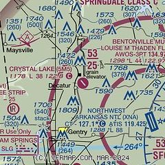
|
| Airport distance calculator |
|---|
|
|
| Sunrise and sunset |
|---|
|
Times for 17-Jul-2026
| | Local
(UTC-5) | | Zulu
(UTC) |
|---|
| Morning civil twilight | | 05:45 | | 10:45 |
| Sunrise | | 06:14 | | 11:14 |
| Sunset | | 20:34 | | 01:34 |
| Evening civil twilight | | 21:03 | | 02:03 |
|
| Current date and time |
|---|
| Zulu (UTC) | 17-Jul-2026 08:42:21 |
|---|
| Local (UTC-5) | 17-Jul-2026 03:42:21 |
|---|
|
| METAR |
|---|
KXNA
8nm SE | 170753Z AUTO 18004KT 10SM CLR 22/21 A3016 RMK AO2 SLP197 T02220211 $
|
KSLG
9nm S | 170756Z AUTO 15004KT 10SM CLR 22/22 A3016 RMK AO2 SLP200 T02170217
|
KVBT
11nm E | 170756Z AUTO 17003KT 10SM CLR 23/ A3017 RMK AO2 SLP205 T0228
|
KROG
18nm E | 170758Z AUTO 20003KT 10SM CLR 23/21 A3016 RMK AO2 SLP196 T02280206
|
KASG
19nm SE | 170148Z 22003KT 10SM CLR 28/26 A3012
|
|
| TAF |
|---|
KXNA
8nm SE | 170520Z 1706/1806 20003KT P6SM BKN150 FM171500 21010KT P6SM SCT045 BKN150 FM180200 20004KT P6SM BKN150
|
KROG
18nm E | 170520Z 1706/1806 18004KT P6SM BKN150 FM171500 22010KT P6SM SCT045 BKN150 FM180200 18004KT P6SM BKN150
|
|
| NOTAMs |
|---|
NOTAMs are issued by the DoD/FAA and will open in a separate window not controlled by AirNav.
|
|

