FAA INFORMATION EFFECTIVE 30 OCTOBER 2025
Location
| FAA Identifier: | 6B0 |
| Lat/Long: | 43-59-11.2990N 073-05-43.9860W
43-59.188317N 073-05.733100W
43.9864719,-73.0955517
(estimated) |
| Elevation: | 494.1 ft. / 150.6 m (surveyed) |
| Variation: | 15W (1985) |
| From city: | 3 miles SE of MIDDLEBURY, VT |
| Time zone: | UTC -5 (UTC -4 during Daylight Saving Time) |
| Zip code: | 05753 |
Airport Operations
| Airport use: | Open to the public |
| Activation date: | 10/1952 |
| Control tower: | no |
| ARTCC: | BOSTON CENTER |
| FSS: | BURLINGTON FLIGHT SERVICE STATION |
| NOTAMs facility: | BTV (NOTAM-D service available) |
| Attendance: | M-F 0700-1530 |
| Pattern altitude: | 1304.1 ft. MSL
810 FT AGL SINGL ENG, 1010 FT AGL MULT ENG. |
| Wind indicator: | yes |
| Segmented circle: | yes
SEGMENTED CIRCLE NON-STANDARD. ONLY TFC PAT INDICATORS. |
Airport Communications
| CTAF/UNICOM: | 122.8 |
| WX AWOS-3: | 118.575 (802-388-0255) |
Nearby radio navigation aids
| VOR radial/distance | | VOR name | | Freq | | Var |
|---|
| BTVr186/24.9 | | BURLINGTON VOR/DME | | 117.50 | | 15W |
| MPVr274/28.5 | | MONTPELIER VOR/DME | | 116.90 | | 16W |
| NDB name | | Hdg/Dist | | Freq | | Var | | ID |
|---|
| SMUTO | | 355/17.9 | | 221 | | 15W | | DYO | -.. -.-- --- |
Airport Services
| Fuel available: | 100LL
100LL:FULL SVC ONLY M-F DAWN TO DUSK. |
| Parking: | tiedowns |
| Airframe service: | MAJOR |
| Powerplant service: | MAJOR |
| Bottled oxygen: | NONE |
| Bulk oxygen: | NONE |
Runway Information
Runway 1/19
| Dimensions: | 3206 x 60 ft. / 977 x 18 m |
| Surface: | asphalt, in good condition |
| Weight bearing capacity: | |
| RUNWAY 1 | | RUNWAY 19 |
| Latitude: | 43-58.924643N | | 43-59.451990N |
| Longitude: | 073-05.719148W | | 073-05.747065W |
| Elevation: | 484.8 ft. | | 484.8 ft. |
| Traffic pattern: | left | | right |
| Runway heading: | 013 magnetic, 358 true | | 193 magnetic, 178 true |
| Displaced threshold: | 141 ft. | | no |
| Declared distances: | TORA:3206 TODA:3206 ASDA:3206 LDA:3065 | | TORA:3065 TODA:3065 ASDA:3206 LDA:3065 |
| Markings: | nonprecision, in good condition | | basic, in good condition |
| Runway end identifier lights: | no | | no |
| Touchdown point: | yes, no lights | | yes, no lights |
| Obstructions: | 15 ft. trees, 201 ft. from runway, 125 ft. left and right of centerline
20 FT TREES, 99-199 FT, 124 FT R. | | 95 ft. trees, 1760 ft. from runway, 280 ft. left and right of centerline, 16:1 slope to clear |
Airport Ownership and Management from official FAA records
| Ownership: | Publicly-owned |
| Owner: | STATE OF VERMONT
219 N MAIN ST
BARRE, VT 05641
Phone 802-272-7725 |
| Manager: | CHRISTOPHER BEITZEL
219 N MAIN ST
BARRE, VT 05641
Phone 802-272-7725 |
Additional Remarks
| - | HIGH HILLS EAST OF ARPT. |
| - | RWY CONDS MAY NOT BE MNT OR RPRTD WHEN THE ARPT IS UNATNDD. |
| - | ULTRA-LIGHT & AGRICULTURAL ACFT ACTVTY ON & INVOF ARPT. |
| - | NO LN OF SIGHT BTN RWY ENDS. |
| - | PAJA ON WKENDS. |
| - | FOR CD CTC BURLINGTON APCH AT 802-657-4413, WHEN APCH CLSD CTC BOSTON ARTCC AT 603-879-6859. |
Instrument Procedures
There are no published instrument procedures at 6B0.
Some nearby airports with instrument procedures:
4B6 - Ticonderoga Municipal Airport (15 nm SW)
KMPV - Edward F Knapp State Airport (26 nm NE)
KRUT - Rutland/Southern Vermont Regional Airport (28 nm S)
KBTV - Patrick Leahy Burlington International Airport (29 nm N)
KMVL - Morrisville-Stowe State Airport (39 nm NE)
|
|

Road maps at:
MapQuest
Bing
Google
| Aerial photo |
|---|
WARNING: Photo may not be current or correct

Do you have a better or more recent aerial photo of Middlebury State Airport that you would like to share? If so, please send us your photo.
|
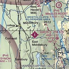
| Sectional chart |
|---|
|
| Airport distance calculator |
|---|
|
|
| Sunrise and sunset |
|---|
|
Times for 06-Nov-2025
| | Local
(UTC-5) | | Zulu
(UTC) |
|---|
| Morning civil twilight | | 06:06 | | 11:06 |
| Sunrise | | 06:36 | | 11:36 |
| Sunset | | 16:36 | | 21:36 |
| Evening civil twilight | | 17:06 | | 22:06 |
|
| Current date and time |
|---|
| Zulu (UTC) | 06-Nov-2025 16:40:29 |
|---|
| Local (UTC-5) | 06-Nov-2025 11:40:29 |
|---|
|
| METAR |
|---|
| K6B0 | 061615Z AUTO 33009G16KT 10SM SCT038 BKN044 BKN085 06/M03 A2994 RMK AO2 LTG DSNT E T00641028
|
|
| TAF |
|---|
KMPV
26nm NE | 061138Z 0612/0712 30010G20KT P6SM -RA SCT015 BKN040 TEMPO 0612/0614 6SM -SHRA BR BKN015 FM061400 31012G21KT P6SM SCT018 OVC040 FM062300 29010KT P6SM SCT045 FM070600 00000KT P6SM SCT200
|
KRUT
29nm S | 061138Z 0612/0712 29008G15KT P6SM -SHRA SCT024 OVC035 TEMPO 0612/0613 6SM -SHRA RA OVC024 FM061500 31013G20KT P6SM BKN035 FM062000 30009G18KT P6SM SCT035 FM062300 29006KT P6SM FEW070 FM070500 VRB04KT P6SM FEW190
|
KBTV
29nm N | 061446Z 0615/0712 32016G30KT P6SM SCT028 BKN035 OVC060 FM062100 29010KT P6SM SCT060 FM070600 VRB04KT P6SM FEW190
|
|
| NOTAMs |
|---|
NOTAMs are issued by the DoD/FAA and will open in a separate window not controlled by AirNav.
|
|

