FAA INFORMATION EFFECTIVE 11 JUNE 2026
Location
| FAA Identifier: | 6R6 |
| Lat/Long: | 30-02-47.3000N 102-12-47.4000W
30-02.788333N 102-12.790000W
30.0464722,-102.2131667
(estimated) |
| Elevation: | 2323.4 ft. / 708.2 m (surveyed) |
| Variation: | 09E (1985) |
| From city: | 5 miles W of DRYDEN, TX |
| Time zone: | UTC -5 (UTC -6 during Standard Time) |
| Zip code: | 78851 |
Airport Operations
| Airport use: | Open to the public |
| Activation date: | 11/1943 |
| Control tower: | no |
| ARTCC: | HOUSTON CENTER |
| FSS: | SAN ANGELO FLIGHT SERVICE STATION |
| NOTAMs facility: | SJT (NOTAM-D service available) |
| Attendance: | INTMNT |
| Wind indicator: | lighted |
| Segmented circle: | yes |
| Lights: | ACTVT MIRL RWY 13/31 - CTAF. HELI PAD LGTS, 5 CLICKS - 123.05. |
| Beacon: | white-green (lighted land airport)
Operates sunset to sunrise. |
Airport Communications
Airport Services
| Parking: | tiedowns |
| Airframe service: | NONE |
| Powerplant service: | NONE |
Runway Information
Runway 13/31
| Dimensions: | 4526 x 75 ft. / 1380 x 23 m |
| Surface: | asphalt, in poor condition |
| Weight bearing capacity: | |
| Runway edge lights: | medium intensity |
| RUNWAY 13 | | RUNWAY 31 |
| Latitude: | 30-03.055987N | | 30-02.523283N |
| Longitude: | 102-13.233130W | | 102-12.632020W |
| Elevation: | 2323.4 ft. | | 2291.2 ft. |
| Traffic pattern: | left | | left |
| Runway heading: | 127 magnetic, 136 true | | 307 magnetic, 316 true |
| Markings: | basic, in poor condition | | basic, in poor condition |
| Touchdown point: | yes, no lights | | yes, no lights |
| Obstructions: | 8 ft. fence, 278 ft. from runway, 130 ft. right of centerline, 9:1 slope to clear | | none |
Runway 4/22
| Dimensions: | 4525 x 75 ft. / 1379 x 23 m |
| Surface: | asphalt, in poor condition |
| Weight bearing capacity: | |
| RUNWAY 4 | | RUNWAY 22 |
| Latitude: | 30-02.525863N | | 30-03.048622N |
| Longitude: | 102-12.953938W | | 102-12.341585W |
| Elevation: | 2302.5 ft. | | 2288.0 ft. |
| Traffic pattern: | left | | left |
| Runway heading: | 037 magnetic, 046 true | | 217 magnetic, 226 true |
| Markings: | basic, in poor condition | | basic, in poor condition |
| Touchdown point: | yes, no lights | | yes, no lights |
| Obstructions: | none | | 5 ft. brush, 266 ft. from runway, 125 ft. left and right of centerline, 13:1 slope to clear
10 FT BRUSH, 15 FT DSTC, 20 FT R. |
Airport Ownership and Management from official FAA records
| Ownership: | Publicly-owned |
| Owner: | TERRELL COUNTY
TERRELL CO COURTHOUSE
SANDERSON, TX 79848
Phone 432-345-2421 |
| Manager: | C D CURRY
PO BOX 350
SANDERSON, TX 79848
Phone 432-345-6731 |
Additional Remarks
| - | FOR CD CTC HOUSTON ARTCC AT 281-230-5622. |
| - | RWY 04/22 AND RWY 13/31 EXTSV CRACKING, LOOSE STONES ON SFC. |
| - | RWY 13/31 AND RWY 04/22 MRKG POOR DUE TO PAVEMENT DETERIORATION. |
Instrument Procedures
There are no published instrument procedures at 6R6.
Some nearby airports with instrument procedures:
KFST - Fort Stockton-Pecos County Airport (63 nm NW)
KOZA - Ozona Municipal Airport (67 nm NE)
KDRT - Del Rio International Airport (78 nm SE)
E38 - Alpine-Casparis Municipal Airport (79 nm W)
E41 - Reagan County Airport (79 nm NE)
|
|

Road maps at:
MapQuest
Bing
Google
| Aerial photo |
|---|
WARNING: Photo may not be current or correct
 Photo by Hamlin Photo, provided courtesy of Ameriseal of Ohio
Taken late February 2006
Photo by Hamlin Photo, provided courtesy of Ameriseal of Ohio
Taken late February 2006
Do you have a better or more recent aerial photo of Terrell County Airport that you would like to share? If so, please send us your photo.
|
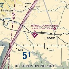
| Sectional chart |
|---|
|
| Airport distance calculator |
|---|
|
|
| Sunrise and sunset |
|---|
|
Times for 09-Jul-2026
| | Local
(UTC-5) | | Zulu
(UTC) |
|---|
| Morning civil twilight | | 06:29 | | 11:29 |
| Sunrise | | 06:56 | | 11:56 |
| Sunset | | 20:52 | | 01:52 |
| Evening civil twilight | | 21:19 | | 02:19 |
|
| Current date and time |
|---|
| Zulu (UTC) | 09-Jul-2026 05:08:34 |
|---|
| Local (UTC-5) | 09-Jul-2026 00:08:34 |
|---|
|
| METAR |
|---|
| K6R6 | 090451Z AUTO 16008KT 29/16 A3005 RMK AO1 SLP135 T02940161 $
|
|
| NOTAMs |
|---|
NOTAMs are issued by the DoD/FAA and will open in a separate window not controlled by AirNav.
|
|


