FAA INFORMATION EFFECTIVE 14 MAY 2026
Location
| FAA Identifier: | 79S |
| Lat/Long: | 47-50-39.0800N 110-38-12.7000W
47-50.651333N 110-38.211667W
47.8441889,-110.6368611
(estimated) |
| Elevation: | 2868.8 ft. / 874 m (estimated) |
| Variation: | 14E (2005) |
| From city: | 1 mile NE of FORT BENTON, MT |
| Time zone: | UTC -6 (UTC -7 during Standard Time) |
| Zip code: | 59442 |
Airport Operations
| Airport use: | Open to the public |
| Activation date: | 04/1940 |
| Control tower: | no |
| ARTCC: | SALT LAKE CITY CENTER |
| FSS: | GREAT FALLS FLIGHT SERVICE STATION |
| NOTAMs facility: | GTF (NOTAM-D service available) |
| Attendance: | UNATNDD |
| Wind indicator: | lighted |
| Segmented circle: | yes |
| Lights: | ACTVT PAPI RWY 05 & 23; MIRL RWY 05/23 - CTAF. |
| Beacon: | white-green (lighted land airport)
Operates sunset to sunrise. |
Airport Communications
| CTAF/UNICOM: | 122.8 |
| WX AWOS-3PT: | 121.125 (406-622-5976) |
- APCH/DEP CTL SVC PRVDD BY SALT LAKE CITY ARTCC ( ZLC) ON FREQS 133.4/285.4 (GREAT FALLS RCAG).
Nearby radio navigation aids
| VOR radial/distance | | VOR name | | Freq | | Var |
|---|
| GTFr037/39.3 | | GREAT FALLS VORTAC | | 115.10 | | 16E |
Airport Services
| Fuel available: | 100LL |
| Parking: | tiedowns |
| Airframe service: | NONE |
| Powerplant service: | NONE |
| Bottled oxygen: | NONE |
| Bulk oxygen: | NONE |
Runway Information
Runway 5/23
| Dimensions: | 4300 x 75 ft. / 1311 x 23 m |
| Surface: | asphalt, in excellent condition |
| Weight bearing capacity: | |
| Runway edge lights: | medium intensity |
| RUNWAY 5 | | RUNWAY 23 |
| Latitude: | 47-50.538833N | | 47-50.874333N |
| Longitude: | 110-38.651333W | | 110-37.726667W |
| Elevation: | 2868.8 ft. | | 2859.5 ft. |
| Traffic pattern: | left | | left |
| Runway heading: | 048 magnetic, 062 true | | 228 magnetic, 242 true |
| Markings: | nonprecision, in good condition | | nonprecision, in good condition |
| Visual slope indicator: | 2-light PAPI on left (3.00 degrees glide path) | | 2-light PAPI on left (3.00 degrees glide path) |
| Touchdown point: | yes, no lights | | yes, no lights |
Runway 14/32
| Dimensions: | 1700 x 75 ft. / 518 x 23 m |
| Surface: | dirt, in good condition |
| RUNWAY 14 | | RUNWAY 32 |
| Latitude: | 47-50.634833N | | 47-50.388667N |
| Longitude: | 110-38.367333W | | 110-38.170333W |
| Elevation: | 2863.2 ft. | | 2866.4 ft. |
| Traffic pattern: | left | | left |
| Runway heading: | 138 magnetic, 152 true | | 318 magnetic, 332 true |
| Touchdown point: | yes, no lights | | yes, no lights |
| Obstructions: | 50 ft. pline, 830 ft. from runway, 16:1 slope to clear | | none |
Airport Ownership and Management from official FAA records
| Ownership: | Publicly-owned |
| Owner: | FT BENTON & CHOUTEAU CO
CHOUTEAU COUNTY COURTHOUSE, PO BOX 459
FORT BENTON, MT 59442
Phone 406-622-9494 |
| Manager: | MIKE MAY
PO BOX 1512, COLONY BAY ROAD
FORT BENTON, MT 59442
Phone (406) 781-9478
OR CONTACT ANDY TAYLOR @ 406-622-5682. |
Additional Remarks
| - | FOR CD CTC SALT LAKE ARTCC AT 801-320-2568. |
| - | (PAY PHONE) PAY PHONE AVAILABLE. |
Instrument Procedures
NOTE: All procedures below are presented as PDF files. If you need a reader for these files, you should download the free Adobe Reader.NOT FOR NAVIGATION. Please procure official charts for flight.
FAA instrument procedures published for use from 14 May 2026 at 0901Z to 11 June 2026 at 0900Z.
IAPs - Instrument Approach Procedures |
|---|
| RNAV (GPS) RWY 23 | |
download (198KB) |
| NOTE: Special Alternate Minimums apply | |
download (37KB) |
| NOTE: Special Take-Off Minimums/Departure Procedures apply | |
download (223KB) |
Other nearby airports with instrument procedures:
KGTF - Great Falls International Airport (37 nm SW)
S64 - Stanford Airport/Biggerstaff Field (45 nm S)
KHVR - Havre City-County Airport (55 nm NE)
S01 - Conrad Airport (57 nm W)
KCII - Choteau Airport (62 nm W)
|
|

Road maps at:
MapQuest
Bing
Google
| Aerial photo |
|---|
WARNING: Photo may not be current or correct
 Photo taken 20-Jul-2014
looking west.
Photo taken 20-Jul-2014
looking west.
Do you have a better or more recent aerial photo of Fort Benton Airport that you would like to share? If so, please send us your photo.
|
| Sectional chart |
|---|
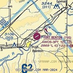
|
| Airport distance calculator |
|---|
|
|
| Sunrise and sunset |
|---|
|
Times for 26-May-2026
| | Local
(UTC-6) | | Zulu
(UTC) |
|---|
| Morning civil twilight | | 04:55 | | 10:55 |
| Sunrise | | 05:33 | | 11:33 |
| Sunset | | 21:06 | | 03:06 |
| Evening civil twilight | | 21:45 | | 03:45 |
|
| Current date and time |
|---|
| Zulu (UTC) | 26-May-2026 14:52:42 |
|---|
| Local (UTC-6) | 26-May-2026 08:52:42 |
|---|
|
| METAR |
|---|
| K79S | 261435Z AUTO 00000KT 10SM CLR 22/09 A2963 RMK AO2 T02230089 $
|
|
| NOTAMs |
|---|
NOTAMs are issued by the DoD/FAA and will open in a separate window not controlled by AirNav.
|
|

