FAA INFORMATION EFFECTIVE 11 JUNE 2026
Location
| FAA Identifier: | 7M5 |
| Lat/Long: | 35-30-38.5050N 093-50-21.5070W
35-30.641750N 093-50.358450W
35.5106958,-93.8393075
(estimated) |
| Elevation: | 648 ft. / 197.5 m (surveyed) |
| Variation: | 04E (1995) |
| From city: | 2 miles NW of OZARK, AR |
| Time zone: | UTC -5 (UTC -6 during Standard Time) |
| Zip code: | 72949 |
Airport Operations
| Airport use: | Open to the public |
| Activation date: | 04/1940 |
| Control tower: | no |
| ARTCC: | MEMPHIS CENTER |
| FSS: | JONESBORO FLIGHT SERVICE STATION |
| NOTAMs facility: | JBR (NOTAM-D service available) |
| Attendance: | UNATTNDD |
| Wind indicator: | lighted |
| Segmented circle: | yes |
| Lights: | DUSK-DAWN. ACTVT MIRL RY 04/22, PAPI RYS 4 &22 - CTAF. |
| Beacon: | white-green (lighted land airport)
Operates sunset to sunrise. |
Airport Communications
| CTAF/UNICOM: | 122.8 |
| RAZORBACK APPROACH: | 120.9 |
| RAZORBACK DEPARTURE: | 120.9 |
- APCH/DEP SVC PRVDD BY MEMPHIS ARTCC ON FREQS 128.475/377.15 (RUSSELLVILLE RCAG) WHEN RAZORBACK APCH CTL CLSD.
Nearby radio navigation aids
| VOR radial/distance | | VOR name | | Freq | | Var |
|---|
| FSMr064/22.4 | | FORT SMITH VORTAC | | 110.40 | | 07E |
| NDB name | | Hdg/Dist | | Freq | | Var | | ID |
|---|
| RUSSELLVILLE | | 290/39.5 | | 379 | | 03E | | RUE | .-. ..- . |
Airport Services
| Fuel available: | 100LL
100LL:SELF SERVICE FUEL AVBL 24 HRS WITH CREDIT CARD. |
| Parking: | tiedowns |
| Bottled oxygen: | NONE |
| Bulk oxygen: | NONE |
Runway Information
Runway 4/22
| Dimensions: | 3302 x 75 ft. / 1006 x 23 m |
| Surface: | asphalt, in good condition |
| Weight bearing capacity: | |
| Runway edge lights: | medium intensity |
| RUNWAY 4 | | RUNWAY 22 |
| Latitude: | 35-30.457067N | | 35-30.826067N |
| Longitude: | 093-50.603000W | | 093-50.113750W |
| Elevation: | 606.0 ft. | | 648.0 ft. |
| Traffic pattern: | left | | left |
| Runway heading: | 043 magnetic, 047 true | | 223 magnetic, 227 true |
| Markings: | nonprecision, in good condition | | nonprecision, in good condition |
| Visual slope indicator: | 2-light PAPI on left (3.00 degrees glide path) | | 2-light PAPI on left (4.00 degrees glide path)
RWY 22 PAPI UNUSBL BYD 2 DEG RIGHT OF CNTRLN. RWY 22 PAPI DOES NOT PRVD OBSTN CLNC BYD 4.0 NM FM THLD, UNUSBL BYD 4.0 NM. |
| Touchdown point: | yes, no lights | | yes, no lights |
| Obstructions: | 5 ft. bldg, 250 ft. from runway, 10:1 slope to clear | | 35 ft. tree, 800 ft. from runway, 350 ft. right of centerline, 17:1 slope to clear |
Airport Ownership and Management from official FAA records
| Ownership: | Publicly-owned |
| Owner: | CITY OF OZARK-FRANKLIN CO
PO BOX 196
OZARK, AR 72949
Phone 479-667-4726
COUNTY JUDGE. |
| Manager: | MIKE PRUETT
P.O. BOX 262
OZARK, AR 72949
Phone 479-751-7225 |
Additional Remarks
| - | USE EXTRM CTN, WILDLIFE MAY BE ON FLD. |
| - | FOR CD CTC RAZORBACK APCH AT 479-649-2416, WHEN APCH CLSD CTC MEMPHIS ARTCC AT 901-368-8453/8449. |
Instrument Procedures
NOTE: All procedures below are presented as PDF files. If you need a reader for these files, you should download the free Adobe Reader.NOT FOR NAVIGATION. Please procure official charts for flight.
FAA instrument procedures published for use from 11 June 2026 at 0901Z to 09 July 2026 at 0900z.
IAPs - Instrument Approach Procedures |
|---|
| RNAV (GPS) RWY 04 | |
download (223KB) |
| NOTE: Special Take-Off Minimums/Departure Procedures apply | |
download (378KB) |
Other nearby airports with instrument procedures:
H35 - Clarksville Municipal Airport (20 nm E)
KFSM - Fort Smith Regional Airport (28 nm W)
32A - Danville Municipal Airport (32 nm SE)
KFYV - Drake Field Airport (34 nm NW)
H34 - Huntsville Municipal Airport (34 nm N)
|
|

Road maps at:
MapQuest
Bing
Google
| Aerial photo |
|---|
WARNING: Photo may not be current or correct
 Photo courtesy of the Arkansas Department of Aeronautics
Taken in the Spring of 2007
Photo courtesy of the Arkansas Department of Aeronautics
Taken in the Spring of 2007
Do you have a better or more recent aerial photo of Ozark/Franklin County Airport that you would like to share? If so, please send us your photo.
|
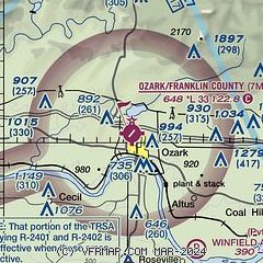
| Sectional chart |
|---|
|
| Airport distance calculator |
|---|
|
|
| Sunrise and sunset |
|---|
|
Times for 09-Jul-2026
| | Local
(UTC-5) | | Zulu
(UTC) |
|---|
| Morning civil twilight | | 05:39 | | 10:39 |
| Sunrise | | 06:09 | | 11:09 |
| Sunset | | 20:32 | | 01:32 |
| Evening civil twilight | | 21:02 | | 02:02 |
|
| Current date and time |
|---|
| Zulu (UTC) | 09-Jul-2026 06:44:11 |
|---|
| Local (UTC-5) | 09-Jul-2026 01:44:11 |
|---|
|
| METAR |
|---|
KFSM
28nm W | 090553Z AUTO 00000KT 10SM CLR 29/24 A2996 RMK AO2 SLP137 T02890244 10350 20289 403610228 51007 $
|
KFYV
34nm NW | 090553Z AUTO 00000KT 10SM CLR 26/23 A3000 RMK AO2 SLP141 T02560228 10322 20250 403330200 53006
|
KRUE
39nm SE | 090553Z AUTO 13003KT 10SM CLR 25/21 A2998 RMK AO2 SLP142 T02500211 10300 20244 403500217 53003
|
KASG
42nm N | 090148Z 20006KT 9SM SCT046 30/28 A2998
|
KJSV
47nm W | 090635Z AUTO 00000KT 10SM CLR 28/28 A2994 RMK AO2
|
KRKR
48nm SW | 090635Z AUTO 00000KT 10SM CLR 27/23 A2996 RMK AO2
|
|
| TAF |
|---|
KFSM
28nm W | 090528Z 0906/1006 VRB05KT P6SM FEW120 FM090800 07006KT P6SM SCT100 SCT200 WS020/22035KT FM091600 23011KT P6SM SCT100 BKN250 FM100200 17006KT P6SM BKN150
|
KFYV
34nm NW | 090528Z 0906/1006 VRB03KT P6SM SCT120 FM090800 19006KT P6SM SCT100 SCT200 WS020/22035KT FM091500 20012G20KT P6SM SCT100 BKN250 FM100100 19007KT P6SM BKN150
|
|
| NOTAMs |
|---|
NOTAMs are issued by the DoD/FAA and will open in a separate window not controlled by AirNav.
|
|

