FAA INFORMATION EFFECTIVE 09 JULY 2026
Location
| FAA Identifier: | 7W5 |
| Lat/Long: | 41-22-27.3710N 084-04-04.3650W
41-22.456183N 084-04.072750W
41.3742697,-84.0678792
(estimated) |
| Elevation: | 682.9 ft. / 208.1 m (surveyed) |
| Variation: | 05W (1985) |
| From city: | 3 miles E of NAPOLEON, OH |
| Time zone: | UTC -4 (UTC -5 during Standard Time) |
| Zip code: | 43545 |
Airport Operations
| Airport use: | Open to the public |
| Activation date: | 11/1971 |
| Control tower: | no |
| ARTCC: | CLEVELAND CENTER |
| FSS: | CLEVELAND FLIGHT SERVICE STATION |
| NOTAMs facility: | CLE (NOTAM-D service available) |
| Attendance: | MON-FRI 0800-1730, ALL SAT-SUN ON CALL
FOR SVC CALL AMGR CELL. |
| Wind indicator: | lighted |
| Segmented circle: | no |
| Lights: | ACTVT REIL RWY 10 & 28; PAPI RWY 10 & 28; MIRL RWY 10/28 - CTAF. |
| Beacon: | white-green (lighted land airport)
Operates sunset to sunrise. |
Airport Communications
| CTAF/UNICOM: | 123.0 |
| TOLEDO APPROACH: | 134.35 |
| TOLEDO DEPARTURE: | 134.35 |
| WX AWOS-3PT at USE (14 nm N): | 127.375 (419-335-0775) |
| WX ASOS at DFI (16 nm W): | 121.425 (419-658-2301) |
| WX ASOS at TOL (17 nm NE): | PHONE 419-210-1094 |
| WX AWOS-3PT at 1G0 (20 nm E): | 120.725 (419-354-1415) |
Nearby radio navigation aids
| VOR radial/distance | | VOR name | | Freq | | Var |
|---|
| FBCr333/28.8 | | FLAG CITY VORTAC | | 108.20 | | 02W |
| NDB name | | Hdg/Dist | | Freq | | Var | | ID |
|---|
| TOPHR | | 217/12.6 | | 219 | | 05W | | TO | - --- |
| ADRIAN | | 185/29.7 | | 278 | | 06W | | ADG | .- -.. --. |
Airport Services
| Fuel available: | 100LL JET-A |
| Parking: | hangars and tiedowns |
| Airframe service: | MAJOR |
| Powerplant service: | MAJOR |
| Bottled oxygen: | LOW |
| Bulk oxygen: | NONE |
Runway Information
Runway 10/28
| Dimensions: | 4001 x 60 ft. / 1220 x 18 m |
| Surface: | asphalt, in excellent condition |
| Runway edge lights: | medium intensity |
| RUNWAY 10 | | RUNWAY 28 |
| Latitude: | 41-22.517658N | | 41-22.394668N |
| Longitude: | 084-04.502347W | | 084-03.643177W |
| Elevation: | 680.8 ft. | | 682.8 ft. |
| Traffic pattern: | left | | left |
| Runway heading: | 106 magnetic, 101 true | | 286 magnetic, 281 true |
| Markings: | nonprecision, in good condition | | nonprecision, in good condition |
| Visual slope indicator: | 2-light PAPI on left (3.00 degrees glide path) | | 2-light PAPI on left (3.00 degrees glide path) |
| Runway end identifier lights: | yes | | yes |
| Touchdown point: | yes, no lights | | yes, no lights |
| Obstructions: | 5 ft. crops, 200 ft. from runway, 95 ft. right of centerline
+5 FT CROPS/CULTIVATED FLD, 140-200 FT DIST, 95-125 FT R. | | 6 ft. crops, 200 ft. from runway, 125 ft. left of centerline
+6 FT CROPS/CULTIVATED FLD, 0-200 FT DIST, 125 FT L TO 130 FT R. |
Airport Ownership and Management from official FAA records
| Ownership: | Publicly-owned |
| Owner: | HENRY CO ARPT AUTH
10646 COUNTY ROAD O
NAPOLEON, OH 43545-6217
Phone 419-599-6494 |
| Manager: | JARED AMES, ACTING AMGR
10646 COUNTY ROAD O
NAPOLEON, OH 43545-6217
Phone 419-599-6494
CELL 419-388-9259. |
Additional Remarks
| - | FOR CD CTC TOLEDO APCH AT 419-865-1495. |
Instrument Procedures
NOTE: All procedures below are presented as PDF files. If you need a reader for these files, you should download the free Adobe Reader.NOT FOR NAVIGATION. Please procure official charts for flight.
FAA instrument procedures published for use from 09 July 2026 at 0901Z to 06 August 2026 at 0900Z.
IAPs - Instrument Approach Procedures |
|---|
| RNAV (GPS) RWY 28 | |
download (187KB) |
| NOTE: Special Take-Off Minimums/Departure Procedures apply | |
download (487KB) |
Other nearby airports with instrument procedures:
KUSE - Fulton County Airport (14 nm N)
KDFI - Defiance Memorial Airport (16 nm W)
KTOL - Eugene F Kranz Toledo Express Airport (17 nm NE)
1G0 - Wood County Regional Airport (20 nm E)
0G6 - Williams County Airport (21 nm W)
|
|

Road maps at:
MapQuest
Bing
Google
| Aerial photo |
|---|
WARNING: Photo may not be current or correct
 Photo by Roger Kellogg
Photo taken 29-Sep-2007
Photo by Roger Kellogg
Photo taken 29-Sep-2007
Do you have a better or more recent aerial photo of Henry County Airport that you would like to share? If so, please send us your photo.
|
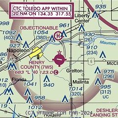
| Sectional chart |
|---|
|
CAUTION: Diagram may not be current

| Airport distance calculator |
|---|
|
|
| Sunrise and sunset |
|---|
|
Times for 29-Jul-2026
| | Local
(UTC-4) | | Zulu
(UTC) |
|---|
| Morning civil twilight | | 05:58 | | 09:58 |
| Sunrise | | 06:29 | | 10:29 |
| Sunset | | 20:56 | | 00:56 |
| Evening civil twilight | | 21:27 | | 01:27 |
|
| Current date and time |
|---|
| Zulu (UTC) | 29-Jul-2026 10:10:57 |
|---|
| Local (UTC-4) | 29-Jul-2026 06:10:57 |
|---|
|
| METAR |
|---|
KUSE
14nm N | 290955Z AUTO 32005KT 10SM CLR 15/15 A2988 RMK AO2
|
KDFI
17nm W | 290953Z AUTO 00000KT 9SM CLR 16/16 A2988 RMK AO2 SLP114 T01560156
|
KTOL
17nm NE | 290952Z 32005KT 10SM CLR 17/14 A2987 RMK AO2 SLP110 T01670144 $
|
KOWX
21nm S | 290955Z AUTO 31003KT 5SM BR CLR 15/15 A2989 RMK AO2
|
KFDY
28nm SE | 290953Z AUTO 33005KT 10SM CLR 17/15 A2985 RMK AO2 SLP101 T01670150
|
KDUH
29nm NE | 290955Z AUTO 33004KT 10SM CLR 16/15 A2987 RMK AO2
|
KTDZ
29nm NE | 290953Z AUTO 35008KT 10SM CLR 19/14 A2986 RMK AO2 SLP108 T01890144 $
|
|
| TAF |
|---|
KTOL
17nm NE | 290523Z 2906/3006 36004KT P6SM FEW045 FM291500 01010G18KT P6SM SCT250 FM300000 02004KT P6SM SKC
|
|
| NOTAMs |
|---|
NOTAMs are issued by the DoD/FAA and will open in a separate window not controlled by AirNav.
|
|


