FAA INFORMATION EFFECTIVE 15 MAY 2025
Location
| FAA Identifier: | 7W6 |
| Lat/Long: | 35-33-43.3330N 075-57-20.3550W
35-33.722217N 075-57.339250W
35.5620369,-75.9556542
(estimated) |
| Elevation: | 6.3 ft. / 1.9 m (surveyed) |
| Variation: | 09W (1985) |
| From city: | 7 miles N of ENGELHARD, NC |
| Time zone: | UTC -4 (UTC -5 during Standard Time) |
| Zip code: | 27824 |
Airport Operations
| Airport use: | Open to the public |
| Activation date: | 01/1981 |
| Control tower: | no |
| ARTCC: | WASHINGTON CENTER |
| FSS: | RALEIGH FLIGHT SERVICE STATION |
| NOTAMs facility: | RDU (NOTAM-D service available) |
| Attendance: | MON-FRI 1300-1600 |
| Wind indicator: | lighted |
| Segmented circle: | yes |
| Lights: | ACTVT PAPI RWY 11 & 29; MIRL RWY 11/29 - CTAF. |
| Beacon: | white-green (lighted land airport)
Operates sunset to sunrise. |
Airport Communications
| CTAF/UNICOM: | 122.7 |
| WX AWOS-3P: | 119.275 (252-925-1136) |
| CHERRY POINT APPROACH: | 119.75 |
| CHERRY POINT DEPARTURE: | 119.75 |
Nearby radio navigation aids
| VOR radial/distance | | VOR name | | Freq | | Var |
|---|
| RBXr218/24.9 | | WRIGHT BROTHERS VOR/DME | | 111.60 | | 08W |
| NDB name | | Hdg/Dist | | Freq | | Var | | ID |
|---|
| MANTEO | | 220/24.7 | | 370 | | 09W | | MQI | -- --.- .. |
Airport Services
| Fuel available: | 100LL
100LL:24 HR SELF SERVE WITH CREDIT CARD. |
| Parking: | tiedowns |
| Airframe service: | NONE |
| Powerplant service: | NONE |
| Bottled oxygen: | NONE |
| Bulk oxygen: | NONE |
Runway Information
Runway 11/29
| Dimensions: | 4700 x 100 ft. / 1433 x 30 m |
| Surface: | asphalt, in fair condition |
| Weight bearing capacity: | | Single wheel: | 30.0 | | Double wheel: | 43.0 |
|
| Runway edge lights: | medium intensity |
| RUNWAY 11 | | RUNWAY 29 |
| Latitude: | 35-33.790118N | | 35-33.654277N |
| Longitude: | 075-57.805952W | | 075-56.872575W |
| Elevation: | 6.2 ft. | | 6.0 ft. |
| Traffic pattern: | right | | left |
| Runway heading: | 109 magnetic, 100 true | | 289 magnetic, 280 true |
| Markings: | nonprecision, in fair condition | | nonprecision, in fair condition |
| Visual slope indicator: | 2-light PAPI on left (3.00 degrees glide path) | | 2-light PAPI on left (3.00 degrees glide path) |
| Touchdown point: | yes, no lights | | yes, no lights |
| Obstructions: | 63 ft. trees, 2999 ft. from runway, 52 ft. right of centerline, 44:1 slope to clear | | 45 ft. trees, 1389 ft. from runway, 195 ft. right of centerline, 26:1 slope to clear |
Airport Ownership and Management from official FAA records
| Ownership: | Publicly-owned |
| Owner: | HYDE COUNTY
PO BOX 95
SWAN QUARTER, NC 27885
Phone (252) 926-4372 |
| Manager: | JANE HODGES
PO BOX 95
SWAN QUARTER, NC 27885
Phone 252-943-4113 |
Additional Remarks
| - | R5314 5 MILES NORTH OF ARPT AND R5313 5 MILES EAST HAVE HEAVY CONCENTRATIONS OF MILITARY ACFT WITHIN 1000' AGL AND IN EXCESS OF 500 KNOTS. MANUEVERING FOR LANDING AND AFTER TAKEOFF SHOULD REMAIN OVER LAND EAST OF ARPT. |
| - | DEER & BIRDS ON & INVOF ARPT. |
| - | GEESE NESTING NORTH SIDE OF RY AT UPPER AND MIDDLE PONDS. |
| - | FOR CD CTC WASHINGTON ARTCC AT 703-771-3587. |
Instrument Procedures
NOTE: All procedures below are presented as PDF files. If you need a reader for these files, you should download the free Adobe Reader.NOT FOR NAVIGATION. Please procure official charts for flight.
FAA instrument procedures published for use from 15 May 2025 at 0901Z to 13 June 2025 at 0900z.
IAPs - Instrument Approach Procedures |
|---|
| RNAV (GPS) RWY 11 | |
download (180KB) |
| NOTE: Special Alternate Minimums apply | |
download (135KB) |
| NOTE: Special Take-Off Minimums/Departure Procedures apply | |
download (282KB) |
Other nearby airports with instrument procedures:
KMQI - Dare County Regional Airport (25 nm NE)
KHSE - Billy Mitchell Airport (26 nm SE)
W95 - Ocracoke Island Airport (28 nm S)
KFFA - First Flight Airport (31 nm NE)
KEDE - Northeastern Regional Airport (41 nm NW)
|
|

Road maps at:
MapQuest
Bing
Google
| Aerial photo |
|---|
WARNING: Photo may not be current or correct
 Photo by Joe Davis
Photo taken 30-May-2015
looking west.
Photo by Joe Davis
Photo taken 30-May-2015
looking west.
Do you have a better or more recent aerial photo of Hyde County Airport that you would like to share? If so, please send us your photo.
|
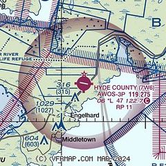
| Sectional chart |
|---|
|
| Airport distance calculator |
|---|
|
|
| Sunrise and sunset |
|---|
|
Times for 07-Jun-2025
| | Local
(UTC-4) | | Zulu
(UTC) |
|---|
| Morning civil twilight | | 05:19 | | 09:19 |
| Sunrise | | 05:49 | | 09:49 |
| Sunset | | 20:16 | | 00:16 |
| Evening civil twilight | | 20:46 | | 00:46 |
|
| Current date and time |
|---|
| Zulu (UTC) | 07-Jun-2025 20:07:15 |
|---|
| Local (UTC-4) | 07-Jun-2025 16:07:15 |
|---|
|
| METAR |
|---|
| K7W6 | 071955Z AUTO 17010G17KT 10SM CLR 30/25 A2976 RMK AO2 T02960245
|
K2DP
8nm N | 071955Z AUTO 19014KT 10SM CLR 32/24 A2974 RMK AO2 SLP078 T03180236 $
|
|
| TAF |
|---|
KECG
44nm N | 071753Z 0718/0818 24010KT P6SM VCSH SCT050 TEMPO 0721/0801 VRB15G30KT 3SM TSRA OVC040CB FM080100 VRB05KT P6SM VCSH BKN035 FM081200 24008KT P6SM BKN008 FM081400 24012G20KT P6SM BKN015
|
|
| NOTAMs |
|---|
NOTAMs are issued by the DoD/FAA and will open in a separate window not controlled by AirNav.
|
|


