FAA INFORMATION EFFECTIVE 21 MARCH 2024
Location
| FAA Identifier: | 9K7 |
| Lat/Long: | 38-45-03.5560N 098-13-45.0180W
38-45.059267N 098-13.750300W
38.7509878,-98.2291717
(estimated) |
| Elevation: | 1632.7 ft. / 497.6 m (surveyed) |
| Variation: | 04E (2025) |
| From city: | 1 mile N of ELLSWORTH, KS |
| Time zone: | UTC -5 (UTC -6 during Standard Time) |
| Zip code: | 67439 |
Airport Operations
| Airport use: | Open to the public |
| Activation date: | 12/1946 |
| Control tower: | no |
| ARTCC: | KANSAS CITY CENTER |
| FSS: | WICHITA FLIGHT SERVICE STATION |
| NOTAMs facility: | ICT (NOTAM-D service available) |
| Attendance: | UNATNDD |
| Wind indicator: | yes |
| Segmented circle: | no |
| Lights: | ACTVT REIL RWY 17 & 35, PAPI RWY 17 & 35; MIRL RWY 17/35 - CTAF. |
| Beacon: | white-green (lighted land airport)
Operates sunset to sunrise. |
Airport Communications
| CTAF/UNICOM: | 122.7 |
| WX AWOS-3P: | 119.675 (785-472-5609) |
- APCH/DEP CTL SVC PRVDD BY KANSAS CITY ARTCC (ZKC) ON 134.9/363.2 (SALINA RCAG).
Nearby radio navigation aids
| VOR radial/distance | | VOR name | | Freq | | Var |
|---|
| SLNr243/30.3 | | SALINA VORTAC | | 117.10 | | 07E |
Airport Services
| Fuel available: | 100LL
100LL:FOR FUEL AFT HRS CALL 785-472-4416. FUEL ALSO AVBL 24 HRS BY CREDIT CARD. |
| Parking: | tiedowns |
| Airframe service: | NONE |
| Powerplant service: | NONE |
| Bottled oxygen: | NONE |
| Bulk oxygen: | NONE |
Runway Information
Runway 17/35
| Dimensions: | 4500 x 75 ft. / 1372 x 23 m |
| Surface: | asphalt, in good condition |
| Weight bearing capacity: | |
| Runway edge lights: | medium intensity |
| RUNWAY 17 | | RUNWAY 35 |
| Latitude: | 38-45.510500N | | 38-44.770167N |
| Longitude: | 098-13.746667W | | 098-13.699833W |
| Elevation: | 1632.7 ft. | | 1608.5 ft. |
| Traffic pattern: | left | | left |
| Runway heading: | 173 magnetic, 177 true | | 353 magnetic, 357 true |
| Markings: | nonprecision, in good condition | | nonprecision, in good condition |
| Visual slope indicator: | 4-light PAPI on left (3.00 degrees glide path) | | 4-light PAPI on left (3.00 degrees glide path) |
| Runway end identifier lights: | yes | | yes |
| Touchdown point: | yes, no lights | | yes, no lights |
| Obstructions: | none | | 40 ft. pole, lighted, 938 ft. from runway, 18:1 slope to clear |
Runway 13/31
| Dimensions: | 1955 x 60 ft. / 596 x 18 m |
| Surface: | turf, in good condition |
| RUNWAY 13 | | RUNWAY 31 |
| Latitude: | 38-44.978833N | | 38-44.766500N |
| Longitude: | 098-13.967168W | | 098-13.658000W |
| Elevation: | 1608.9 ft. | | 1607.7 ft. |
| Traffic pattern: | left | | left |
| Runway heading: | 127 magnetic, 131 true | | 307 magnetic, 311 true |
| Touchdown point: | yes, no lights | | yes, no lights |
Airport Ownership and Management from official FAA records
| Ownership: | Publicly-owned |
| Owner: | CITY OF ELLSWORTH
CITY HALL 1ST & K
ELLSWORTH, KS 67439
Phone 785-472-5566 |
| Manager: | DUSTIN STAMBAUGH
121 W 1ST ST
ELLSWORTH, KS 67439
Phone 785-472-5566 |
Airport Operational Statistics
| Aircraft based on the field: | | 11 | | Single engine airplanes: | | 11 |
| |  | |
| Aircraft operations: avg 55/day * | | 70% | local general aviation | | 30% | transient general aviation | | <1% | military | | * for 12-month period ending 12 September 2018 | |
Additional Remarks
| - | IN APCH AREA TO RWY 35 ARE FENCES; CLUSTER LIGHTS & TOWERS. |
| - | ARPT PUBLIC PHONE NUMBER 785-472-5608. |
| - | FOR CD CTC KANSAS CITY ARTCC AT 913-254-8508. |
Instrument Procedures
NOTE: All procedures below are presented as PDF files. If you need a reader for these files, you should download the free Adobe Reader.NOT FOR NAVIGATION. Please procure official charts for flight.
FAA instrument procedures published for use from 21 March 2024 at 0901Z to 18 April 2024 at 0900z.
IAPs - Instrument Approach Procedures |
|---|
| RNAV (GPS) RWY 17 | |
download (202KB) |
| RNAV (GPS) RWY 35 | |
download (213KB) |
| NOTE: Special Alternate Minimums apply | |
download (146KB) |
| NOTE: Special Take-Off Minimums/Departure Procedures apply | |
download (363KB) |
Other nearby airports with instrument procedures:
KLYO - Lyons-Rice County Municipal Airport (25 nm S)
KSLN - Salina Regional Airport (27 nm E)
KRSL - Russell Municipal Airport (28 nm W)
KMPR - Mc Pherson Airport (35 nm SE)
KGBD - Great Bend Municipal Airport (38 nm SW)
|
|

Road maps at:
MapQuest
Bing
Google
| Aerial photo |
|---|
WARNING: Photo may not be current or correct
 Photo taken 27-May-2010
looking north.
Photo taken 27-May-2010
looking north.
Do you have a better or more recent aerial photo of Ellsworth Municipal Airport that you would like to share? If so, please send us your photo.
|
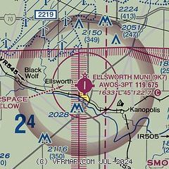
| Sectional chart |
|---|
|
| Airport distance calculator |
|---|
|
|
| Sunrise and sunset |
|---|
|
Times for 15-Apr-2024
| | Local
(UTC-5) | | Zulu
(UTC) |
|---|
| Morning civil twilight | | 06:29 | | 11:29 |
| Sunrise | | 06:56 | | 11:56 |
| Sunset | | 20:09 | | 01:09 |
| Evening civil twilight | | 20:37 | | 01:37 |
|
| Current date and time |
|---|
| Zulu (UTC) | 16-Apr-2024 04:53:15 |
|---|
| Local (UTC-5) | 15-Apr-2024 23:53:15 |
|---|
|
| METAR |
|---|
KLYO
25nm S | 160435Z AUTO 16023G31KT 10SM OVC017 20/17 A2955 RMK AO2 T02020169
|
KSLN
27nm E | 160431Z AUTO 16025G33KT 10SM SCT023 SCT040 21/17 A2956 RMK AO2 PK WND 16035/0414 T02110167
|
KRSL
28nm W | 160436Z AUTO 16022G32KT 10SM FEW023 OVC030 21/17 A2949 RMK AO2 PK WND 15040/0408 LTG DSNT SW T02060172 $
|
KMPR
35nm SE | 160435Z AUTO 15023G29KT 10SM OVC018 20/17 A2958 RMK AO2 T02020171
|
KGBD
38nm SW | 160356Z AUTO 16028G37KT 10SM OVC021 21/18 A2951 RMK AO2 PK WND 15037/0352 LTG DSNT W SLP976 T02110178
|
KHUT
44nm SE | 160352Z AUTO 15020G36KT 10SM OVC018 21/17 A2960 RMK AO2 PK WND 14036/0344 SLP004 T02060172
|
KHYS
49nm W | 160442Z AUTO 17021G34KT 8SM VCTS SCT019 BKN070 BKN090 21/17 A2947 RMK AO2 PK WND 17037/0423 LTG DSNT SE AND W TSB36
|
|
| TAF |
|---|
KSLN
27nm E | 160259Z 1603/1624 16024G34KT P6SM OVC028 FM160700 17027G38KT P6SM VCTS BKN028CB FM161000 20015G24KT P6SM SCT250 FM161700 23025G36KT P6SM FEW250
|
KRSL
28nm W | 160259Z 1603/1624 15028G38KT P6SM BKN018 TEMPO 1605/1608 4SM TSRA BR OVC025CB FM160900 20016G25KT P6SM BKN060 FM161700 26022G32KT P6SM SCT250
|
|
| NOTAMs |
|---|
NOTAMs are issued by the DoD/FAA and will open in a separate window not controlled by AirNav.
|
|

