FAA INFORMATION EFFECTIVE 27 NOVEMBER 2025
Location
| FAA Identifier: | ANW |
| Lat/Long: | 42-34-45.2000N 099-59-34.7000W
42-34.753333N 099-59.578333W
42.5792222,-99.9929722
(estimated) |
| Elevation: | 2588.7 ft. / 789.0 m (surveyed) |
| Variation: | 06E (2010) |
| From city: | 6 miles NW of AINSWORTH, NE |
| Time zone: | UTC -6 (UTC -5 during Daylight Saving Time) |
| Zip code: | 69214 |
Airport Operations
| Airport use: | Open to the public |
| Activation date: | 12/1944 |
| Control tower: | no |
| ARTCC: | DENVER CENTER |
| FSS: | COLUMBUS FLIGHT SERVICE STATION |
| NOTAMs facility: | ANW (NOTAM-D service available) |
| Attendance: | MON-FRI 0800-1700 |
| Wind indicator: | lighted |
| Segmented circle: | yes |
| Lights: | ACTVT MALSR RWY 17 & 35; REIL RWY 31; PAPI RWY 13 & 31, 17 & 35 & HIRL 13/31 & RWY 17/35 - CTAF. |
| Beacon: | white-green (lighted land airport)
Operates sunset to sunrise. |
Airport Communications
| CTAF/UNICOM: | 122.8 |
| WX AWOS-3: | 118.325 (402-387-2329) |
- APCH/DEP CTL SVC PRVDD BY DENVER ARTCC (ZDV) ON FREQ 127.95/338.2 (AINSWORTH RCAG).
Nearby radio navigation aids
| VOR radial/distance | | VOR name | | Freq | | Var |
|---|
| ANW at field | | AINSWORTH VOR/DME | | 112.70 | | 09E |
| NDB name | | Hdg/Dist | | Freq | | Var | | ID |
|---|
| VALENTINE | | 117/29.8 | | 314 | | 08E | | VTN | ...- - -. |
Airport Services
| Fuel available: | 100LL JET-A
100LL:24 HR SELF SVC FUEL AVBL VIA CREDIT CARD SYSTEM. |
| Parking: | hangars and tiedowns |
| Airframe service: | NONE |
| Powerplant service: | NONE |
| Bottled oxygen: | NONE |
| Bulk oxygen: | NONE |
Runway Information
Runway 17/35
| Dimensions: | 6824 x 110 ft. / 2080 x 34 m |
| Surface: | asphalt, in good condition |
| Weight bearing capacity: | | Single wheel: | 30.0 | | Double wheel: | 45.0 |
|
| Runway edge lights: | high intensity |
| RUNWAY 17 | | RUNWAY 35 |
| Latitude: | 42-35.168195N | | 42-34.045033N |
| Longitude: | 099-59.799193W | | 099-59.781272W |
| Elevation: | 2586.5 ft. | | 2588.4 ft. |
| Traffic pattern: | left | | left |
| Runway heading: | 173 magnetic, 179 true | | 353 magnetic, 359 true |
| Markings: | precision, in good condition | | precision, in good condition |
| Visual slope indicator: | 4-light PAPI on left (3.00 degrees glide path) | | 4-light PAPI on left (3.00 degrees glide path) |
| Approach lights: | MALSR: 1,400 foot medium intensity approach lighting system with runway alignment indicator lights | | MALSR: 1,400 foot medium intensity approach lighting system with runway alignment indicator lights |
| Touchdown point: | yes, no lights | | yes, no lights |
| Obstructions: | 5 ft. berm, 347 ft. from runway, 522 ft. right of centerline, 32:1 slope to clear
BERM IS ACTUALLY 4.5 FT; WHICH GIVES THE 32:1 OBSTN CLNC SLOPE. | | 48 ft. trees, 2259 ft. from runway, 306 ft. right of centerline, 42:1 slope to clear |
Runway 13/31
| Dimensions: | 5501 x 75 ft. / 1677 x 23 m |
| Surface: | asphalt, in good condition |
| Weight bearing capacity: | | Single wheel: | 24.0 | | Double wheel: | 36.0 |
|
| Runway edge lights: | high intensity |
| RUNWAY 13 | | RUNWAY 31 |
| Latitude: | 42-35.252505N | | 42-34.619708N |
| Longitude: | 099-59.753148W | | 099-58.876517W |
| Elevation: | 2586.7 ft. | | 2582.6 ft. |
| Traffic pattern: | left | | left |
| Runway heading: | 128 magnetic, 134 true | | 308 magnetic, 314 true |
| Markings: | nonprecision, in good condition | | nonprecision, in fair condition |
| Visual slope indicator: | 2-light PAPI on left (3.00 degrees glide path) | | 2-light PAPI on left (3.00 degrees glide path) |
| Runway end identifier lights: | no | | yes |
| Touchdown point: | yes, no lights | | yes, no lights |
Helipad H1
| Dimensions: | 50 x 50 ft. / 15 x 15 m |
| Surface: | asphalt, in good condition |
| Latitude: | 42-34.612667N | | |
| Longitude: | 100-00.023667W | | |
| Elevation: | 2582.0 ft. | | |
| Traffic pattern: | left | | left |
Airport Ownership and Management from official FAA records
| Ownership: | Publicly-owned |
| Owner: | AINSWORTH ARPT AUTH
PO BOX 84
AINSWORTH, NE 69210-0084
Phone 402-387-1491
ARPT MGR. |
| Manager: | LANCE SCHIPPOREIT
PO BOX 84
AINSWORTH, NE 69210-0084
Phone 402-387-1491
AMGR HOME PHONE 402-387-1255/1-800-303-1491. ON CALL. |
Additional Remarks
| - | HELIPAD FOR REFUELING ONLY. NOT AVBL FOR INST APCHS. |
| - | SEASONAL MIGRATORY WATERFOWL ON & INVOF ARPT. |
| - | FOR CD CTC DENVER ARTCC ON FREQ. IF UNA, CTC FSS ON FREQ VIA RCO. IF UNA, CTC DENVER ARTCC AT 303-651-4257. |
Instrument Procedures
NOTE: All procedures below are presented as PDF files. If you need a reader for these files, you should download the free Adobe Reader.NOT FOR NAVIGATION. Please procure official charts for flight.
FAA instrument procedures published for use from 27 November 2025 at 0901Z to 25 December 2025 at 0900Z.
IAPs - Instrument Approach Procedures |
|---|
| RNAV (GPS) RWY 13 | |
download (229KB) |
| RNAV (GPS) RWY 17 | |
download (229KB) |
| RNAV (GPS) RWY 31 | |
download (210KB) |
| RNAV (GPS) RWY 35 | |
download (229KB) |
| VOR RWY 17 | |
download (169KB) |
| VOR RWY 35 | |
download (209KB) |
| NOTE: Special Alternate Minimums apply | |
download (15KB) |
| NOTE: Special Take-Off Minimums/Departure Procedures apply | |
download (147KB) |
Other nearby airports with instrument procedures:
KRBE - Rock County Airport (19 nm E)
KVTN - Miller Field Airport (30 nm NW)
8V2 - Stuart-Atkinson Municipal Airport (42 nm E)
KTIF - Thomas County Airport (45 nm SW)
9D1 - Gregory Municipal Airport/Flynn Field (46 nm NE)
|
|

Road maps at:
MapQuest
Bing
Google
| Aerial photo |
|---|
WARNING: Photo may not be current or correct
 Photo by Travis Ammon
Taken in the Summer of 2010
looking north.
Photo by Travis Ammon
Taken in the Summer of 2010
looking north.
Do you have a better or more recent aerial photo of Ainsworth Regional Airport that you would like to share? If so, please send us your photo.
|
| Sectional chart |
|---|
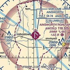
|
| Airport distance calculator |
|---|
|
|
| Sunrise and sunset |
|---|
|
Times for 10-Dec-2025
| | Local
(UTC-6) | | Zulu
(UTC) |
|---|
| Morning civil twilight | | 07:28 | | 13:28 |
| Sunrise | | 08:00 | | 14:00 |
| Sunset | | 17:06 | | 23:06 |
| Evening civil twilight | | 17:38 | | 23:38 |
|
| Current date and time |
|---|
| Zulu (UTC) | 10-Dec-2025 13:48:17 |
|---|
| Local (UTC-6) | 10-Dec-2025 07:48:17 |
|---|
|
| METAR |
|---|
| KANW | 101335Z AUTO 32014G23KT 10SM BKN026 02/M04 A3008 RMK AO2 T00151038
|
|
| TAF |
|---|
KVTN
30nm NW | 101120Z 1012/1112 32015G25KT P6SM SCT250 FM101700 33012KT P6SM BKN200 FM102000 32008KT P6SM FEW100 BKN200 FM102200 28006KT P6SM OVC080 FM102300 13005KT P6SM OVC070 FM110300 13007KT P6SM OVC050
|
|
| NOTAMs |
|---|
NOTAMs are issued by the DoD/FAA and will open in a separate window not controlled by AirNav.
|
|

